Saugerties Topo Map New York
To zoom in, hover over the map of Saugerties
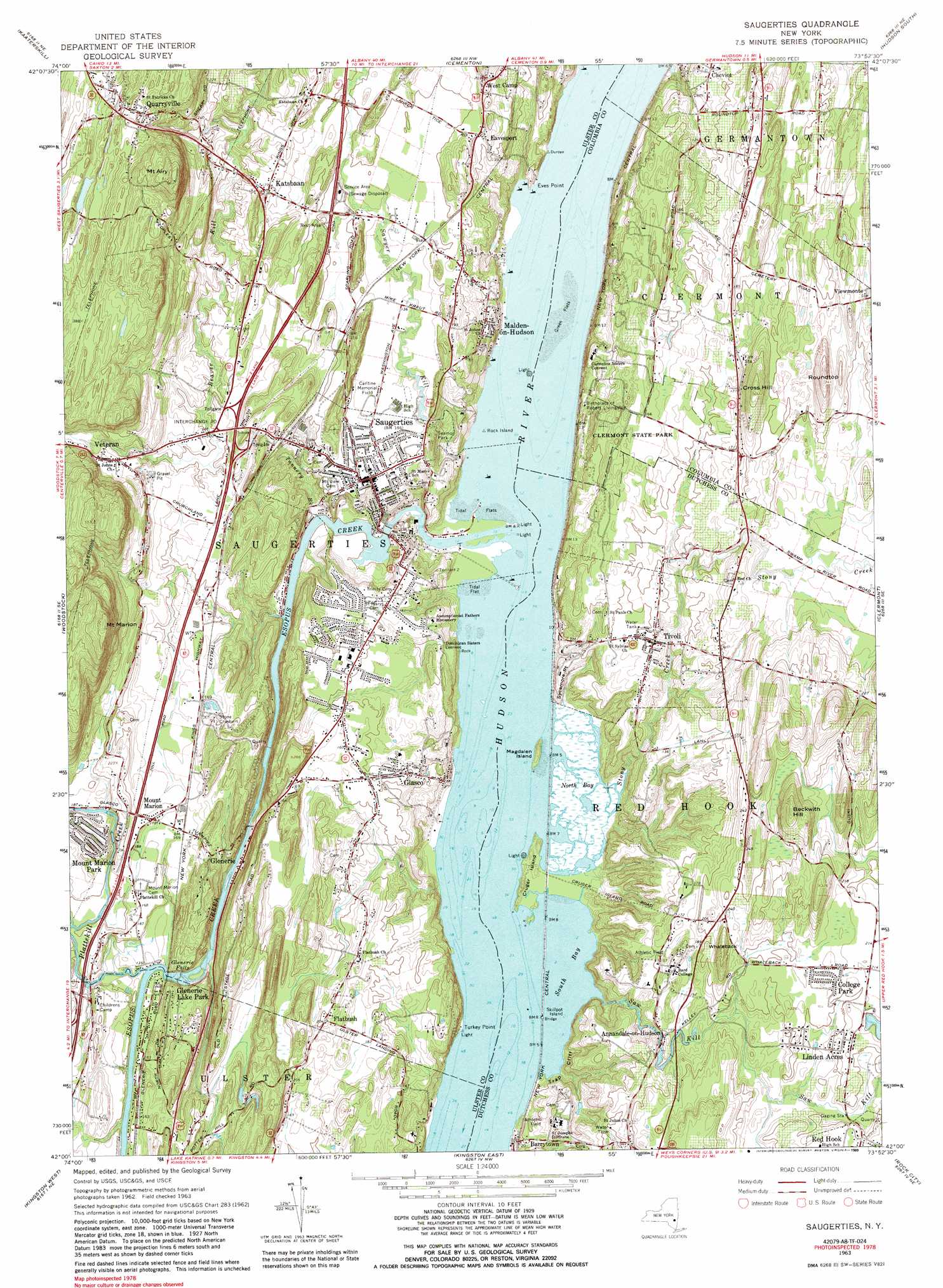
USGS Topo Quad 42073a8 - 1:24,000 scale
| Topo Map Name: | Saugerties |
| USGS Topo Quad ID: | 42073a8 |
| Print Size: | ca. 21 1/4" wide x 27" high |
| Southeast Coordinates: | 42° N latitude / 73.875° W longitude |
| Map Center Coordinates: | 42.0625° N latitude / 73.9375° W longitude |
| U.S. State: | NY |
| Filename: | o42073a8.jpg |
| Download Map JPG Image: | Saugerties topo map 1:24,000 scale |
| Map Type: | Topographic |
| Topo Series: | 7.5´ |
| Map Scale: | 1:24,000 |
| Source of Map Images: | United States Geological Survey (USGS) |
| Alternate Map Versions: |
Saugerties NY 1963, updated 1965 Download PDF Buy paper map Saugerties NY 1963, updated 1971 Download PDF Buy paper map Saugerties NY 1963, updated 1981 Download PDF Buy paper map Saugerties NY 1963, updated 1989 Download PDF Buy paper map Saugerties NY 1963, updated 1989 Download PDF Buy paper map Saugerties NY 1997, updated 2000 Download PDF Buy paper map Saugerties NY 2010 Download PDF Buy paper map Saugerties NY 2013 Download PDF Buy paper map Saugerties NY 2016 Download PDF Buy paper map |
1:24,000 Topo Quads surrounding Saugerties
Hensonville |
Freehold |
Leeds |
Hudson North |
Stottville |
Hunter |
Kaaterskill |
Cementon |
Hudson South |
Claverack |
Bearsville |
Woodstock |
Saugerties |
Clermont |
Ancram |
Ashokan |
Kingston West |
Kingston East |
Rock City |
Pine Plains |
Mohonk Lake |
Rosendale |
Hyde Park |
Salt Point |
Millbrook |
> Back to 42073a1 at 1:100,000 scale
> Back to 42072a1 at 1:250,000 scale
> Back to U.S. Topo Maps home
Saugerties topo map: Gazetteer
Saugerties: Bars
Green Flats elevation 0m 0′Hogs Back elevation 0m 0′
Saddle Bags elevation 0m 0′
Tidal Flat elevation 0m 0′
Saugerties: Bays
South Bay elevation 0m 0′Saugerties: Capes
Eves Point elevation 3m 9′Sycamore Point elevation 17m 55′
Turkey Point elevation 1m 3′
Washburns Point elevation 0m 0′
Saugerties: Channels
Malden on Hudson Reach elevation 0m 0′Saugerties: Cliffs
Trap Cliff elevation 15m 49′Saugerties: Crossings
Interchange 20 elevation 54m 177′Saugerties: Falls
Glenerie Falls elevation 30m 98′Saugerties: Islands
Cruger Island elevation 3m 9′Magdalen Island elevation 9m 29′
Rock Island elevation 0m 0′
Skillpot Island elevation 0m 0′
Saugerties: Parks
Bristol Beach State Park elevation 21m 68′Cantine Memorial Field elevation 42m 137′
Clermont State Historic Site elevation 24m 78′
Clermont State Park elevation 51m 167′
Lorenzo Ferrari Soccer Complex elevation 43m 141′
Seamon Park elevation 52m 170′
Seth Goldfine Memorial Field elevation 51m 167′
Tivoli Bay State Unique Area elevation 0m 0′
Turkey Point State Open Space Area elevation 43m 141′
Ulster Landing County Park elevation 36m 118′
Saugerties: Populated Places
Annandale-on-Hudson elevation 47m 154′Canoe Hill elevation 55m 180′
College Park elevation 64m 209′
Cruger Village elevation 47m 154′
Eavesport elevation 48m 157′
Flatbush elevation 61m 200′
Glasco elevation 46m 150′
Glenerie elevation 26m 85′
Glenerie Lake Park elevation 62m 203′
Katsbaan elevation 54m 177′
Linden Acres elevation 65m 213′
Malden-on-Hudson elevation 26m 85′
Mount Marion elevation 53m 173′
Mount Marion Park elevation 63m 206′
Quarryville elevation 121m 396′
Saugerties elevation 47m 154′
Tivoli elevation 46m 150′
Veteran elevation 72m 236′
West Camp elevation 56m 183′
Saugerties: Streams
Esopus Creek elevation 0m 0′Plattekill Creek elevation 36m 118′
Saw Kill elevation 0m 0′
Sawyer Kill elevation 9m 29′
Stony Creek elevation 0m 0′
Tannery Brook elevation 15m 49′
Saugerties: Summits
Beckwith Hill elevation 115m 377′Cross Hill elevation 93m 305′
Mount Airy elevation 186m 610′
Mount Marion elevation 223m 731′
Roundtop elevation 102m 334′
Whaleback elevation 93m 305′
Saugerties: Swamps
North Bay elevation 0m 0′Saugerties digital topo map on disk
Buy this Saugerties topo map showing relief, roads, GPS coordinates and other geographical features, as a high-resolution digital map file on DVD:
New York, Vermont, Connecticut & Western Massachusetts
Buy digital topo maps: New York, Vermont, Connecticut & Western Massachusetts