Hyde Park Topo Map New York
To zoom in, hover over the map of Hyde Park
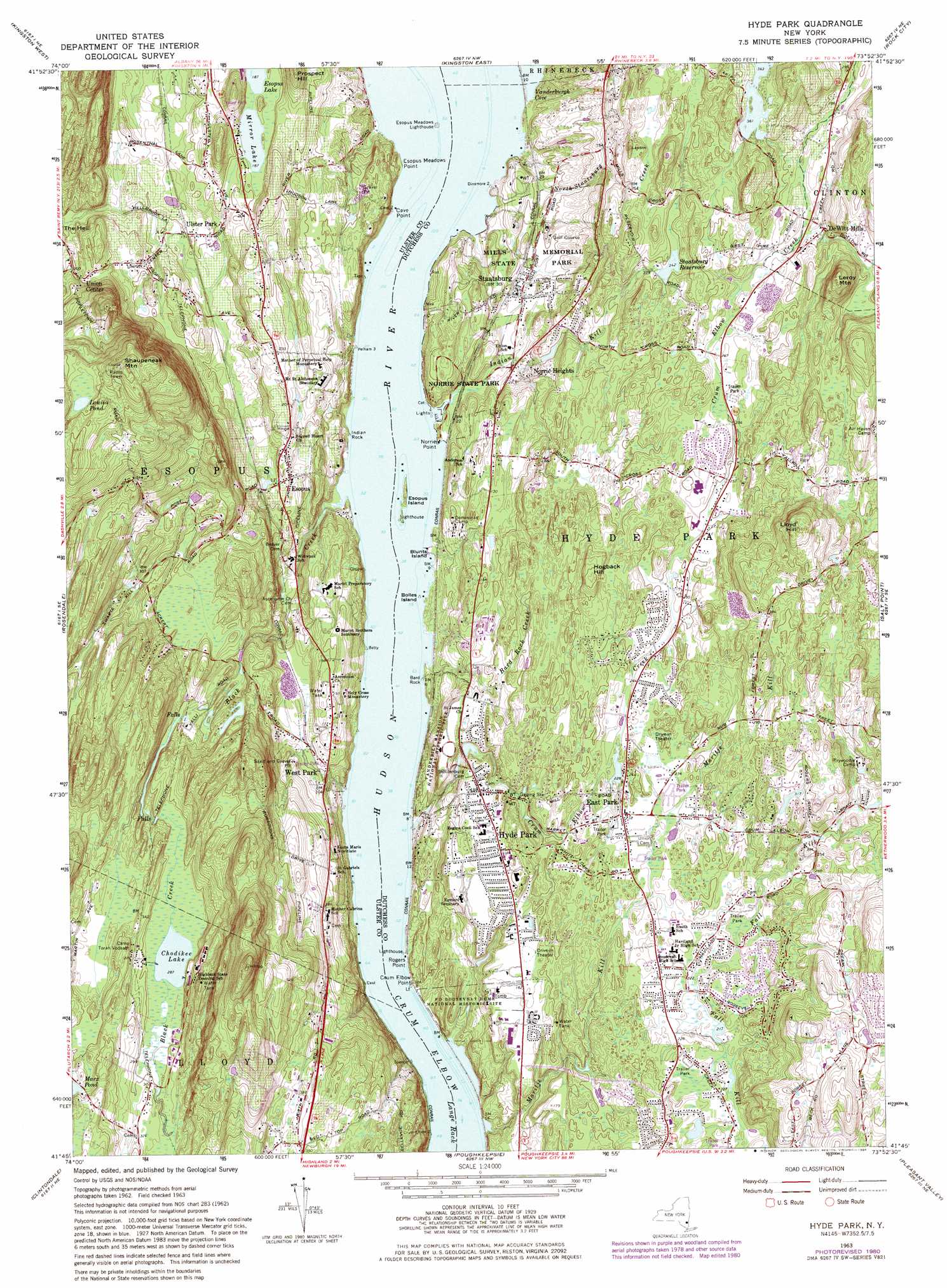
USGS Topo Quad 41073g8 - 1:24,000 scale
| Topo Map Name: | Hyde Park |
| USGS Topo Quad ID: | 41073g8 |
| Print Size: | ca. 21 1/4" wide x 27" high |
| Southeast Coordinates: | 41.75° N latitude / 73.875° W longitude |
| Map Center Coordinates: | 41.8125° N latitude / 73.9375° W longitude |
| U.S. State: | NY |
| Filename: | o41073g8.jpg |
| Download Map JPG Image: | Hyde Park topo map 1:24,000 scale |
| Map Type: | Topographic |
| Topo Series: | 7.5´ |
| Map Scale: | 1:24,000 |
| Source of Map Images: | United States Geological Survey (USGS) |
| Alternate Map Versions: |
Hyde Park NY 1963, updated 1965 Download PDF Buy paper map Hyde Park NY 1963, updated 1971 Download PDF Buy paper map Hyde Park NY 1980, updated 1981 Download PDF Buy paper map Hyde Park NY 1980, updated 1984 Download PDF Buy paper map Hyde Park NY 2010 Download PDF Buy paper map Hyde Park NY 2013 Download PDF Buy paper map Hyde Park NY 2016 Download PDF Buy paper map |
1:24,000 Topo Quads surrounding Hyde Park
Bearsville |
Woodstock |
Saugerties |
Clermont |
Ancram |
Ashokan |
Kingston West |
Kingston East |
Rock City |
Pine Plains |
Mohonk Lake |
Rosendale |
Hyde Park |
Salt Point |
Millbrook |
Gardiner |
Clintondale |
Poughkeepsie |
Pleasant Valley |
Verbank |
Walden |
Newburgh |
Wappingers Falls |
Hopewell Junction |
Poughquag |
> Back to 41073e1 at 1:100,000 scale
> Back to 41072a1 at 1:250,000 scale
> Back to U.S. Topo Maps home
Hyde Park topo map: Gazetteer
Hyde Park: Airports
Airhaven Airport elevation 120m 393′Hyde Park: Areas
The Hell elevation 66m 216′Hyde Park: Bends
Crum Elbow elevation 0m 0′Hyde Park: Capes
Cave Point elevation 30m 98′Crum Elbow Point elevation 6m 19′
Dinsmore Point elevation 12m 39′
Esopus Meadows Point elevation 12m 39′
Norrie Point elevation 0m 0′
Rogers Point elevation 2m 6′
Hyde Park: Cliffs
Bard Rock elevation 2m 6′Indian Rock elevation 5m 16′
Hyde Park: Dams
DeFlora Brothers Dam elevation 110m 360′Hyde Park: Harbors
Norrie Yacht Basin elevation 25m 82′Hyde Park: Islands
Blunts Island elevation 0m 0′Bolles Island elevation 0m 0′
Esopus Island elevation 0m 0′
Hyde Park: Lakes
Chodikee Lake elevation 88m 288′Louisa Pond elevation 220m 721′
Mirror Lake elevation 57m 187′
Hyde Park: Parks
Doty Park elevation 53m 173′Eleanor Roosevelt National Historic Site elevation 67m 219′
Greenfields Park elevation 112m 367′
Home of Franklin D Roosevelt National Historic Site elevation 16m 52′
Kay Park elevation 79m 259′
Main Street-Albertson Street-Park Place Historic District elevation 54m 177′
Margaret Lewis Norrie State Park elevation 1m 3′
Mills Memorial State Park elevation 12m 39′
Pine Woods Park elevation 64m 209′
Vanderbilt Mansion National Historic Site elevation 52m 170′
Hyde Park: Populated Places
DeWitt Mills elevation 84m 275′East Park elevation 71m 232′
Esopus elevation 38m 124′
Haviland elevation 71m 232′
Haviland Mobile Home Park elevation 70m 229′
Hyde Park elevation 57m 187′
Norrie Heights elevation 37m 121′
Staatsburg elevation 9m 29′
Ulster Park elevation 48m 157′
Union Center elevation 86m 282′
West Park elevation 31m 101′
Hyde Park: Reservoirs
Apple Lake elevation 110m 360′Marx Pond elevation 113m 370′
Staatsburg Reservoir elevation 73m 239′
Hyde Park: Streams
Bard Rock Creek elevation 0m 0′Black Creek elevation 1m 3′
Crum Elbow Creek elevation 0m 0′
Indian Kill elevation 6m 19′
Maritje Kill elevation 0m 0′
Middle Hudson River elevation 0m 0′
North Staatsburg Creek elevation 0m 0′
Hyde Park: Summits
Hogback Hill elevation 110m 360′Leroy Mountain elevation 169m 554′
Lloyd Hill elevation 183m 600′
Prospect Hill elevation 104m 341′
Shaupeneak Mountain elevation 272m 892′
Hyde Park digital topo map on disk
Buy this Hyde Park topo map showing relief, roads, GPS coordinates and other geographical features, as a high-resolution digital map file on DVD:
New York, Vermont, Connecticut & Western Massachusetts
Buy digital topo maps: New York, Vermont, Connecticut & Western Massachusetts