North Pownal Topo Map New York
To zoom in, hover over the map of North Pownal
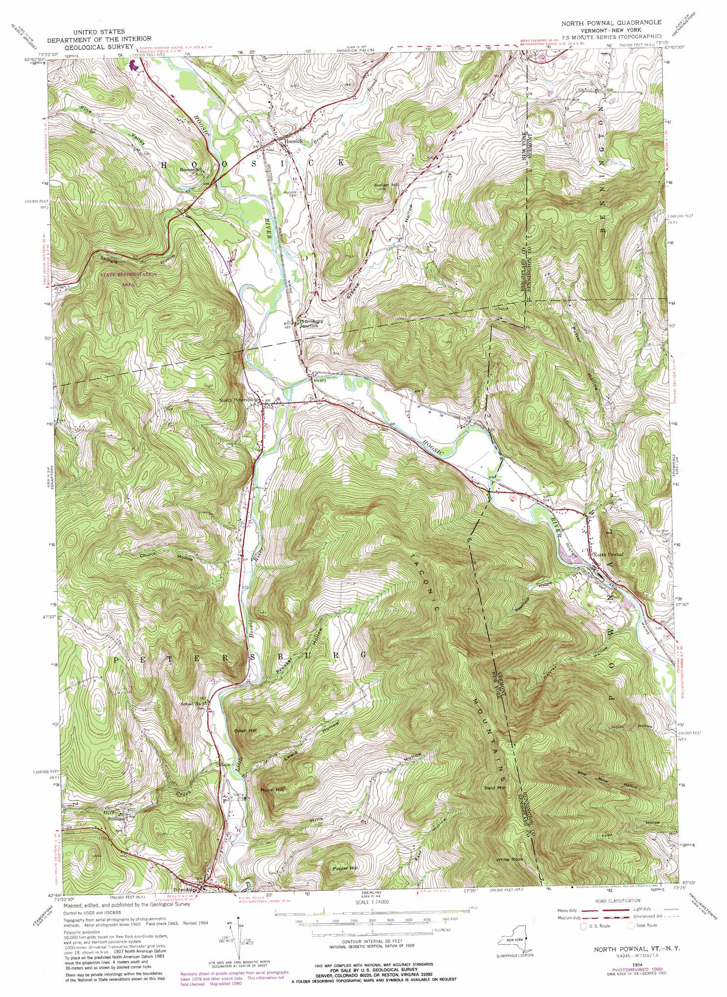
USGS Topo Quad 42073g3 - 1:24,000 scale
| Topo Map Name: | North Pownal |
| USGS Topo Quad ID: | 42073g3 |
| Print Size: | ca. 21 1/4" wide x 27" high |
| Southeast Coordinates: | 42.75° N latitude / 73.25° W longitude |
| Map Center Coordinates: | 42.8125° N latitude / 73.3125° W longitude |
| U.S. States: | NY, VT |
| Filename: | o42073g3.jpg |
| Download Map JPG Image: | North Pownal topo map 1:24,000 scale |
| Map Type: | Topographic |
| Topo Series: | 7.5´ |
| Map Scale: | 1:24,000 |
| Source of Map Images: | United States Geological Survey (USGS) |
| Alternate Map Versions: |
North Pownal VT 1954, updated 1956 Download PDF Buy paper map North Pownal VT 1954, updated 1965 Download PDF Buy paper map North Pownal VT 1954, updated 1980 Download PDF Buy paper map North Pownal VT 1995, updated 2000 Download PDF Buy paper map North Pownal VT 2011 Download PDF Buy paper map North Pownal VT 2015 Download PDF Buy paper map |
| FStopo: | US Forest Service topo North Pownal is available: Download FStopo PDF Download FStopo TIF |
1:24,000 Topo Quads surrounding North Pownal
Schuylerville |
Cambridge |
Shushan |
Arlington |
Sunderland |
Schaghticoke |
Eagle Bridge |
Hoosick Falls |
Bennington |
Woodford |
Tomhannock |
Grafton |
North Pownal |
Pownal |
Stamford |
Averill Park |
Berlin |
North Adams |
||
Nassau |
Hancock |
Windsor |
> Back to 42073e1 at 1:100,000 scale
> Back to 42072a1 at 1:250,000 scale
> Back to U.S. Topo Maps home
North Pownal topo map: Gazetteer
North Pownal: Forests
State Forest Rensselaer Number 3 elevation 267m 875′North Pownal: Populated Places
Hoosick elevation 147m 482′North Petersburg elevation 150m 492′
North Pownal elevation 161m 528′
Petersburg Junction elevation 145m 475′
Stillham elevation 270m 885′
North Pownal: Post Offices
North Pownal Post Office elevation 158m 518′North Pownal: Streams
Browns Brook elevation 130m 426′Dayfoot Brook elevation 200m 656′
Dill Creek elevation 177m 580′
Little Hoosic River elevation 139m 456′
Red Pond Brook elevation 314m 1030′
North Pownal: Summits
Bald Mountain elevation 757m 2483′Indian Hill elevation 331m 1085′
Moon Hill elevation 436m 1430′
Odell Hill elevation 393m 1289′
Poplar Hill elevation 446m 1463′
White Rock elevation 775m 2542′
North Pownal: Valleys
Breese Hollow elevation 148m 485′Church Hollow elevation 163m 534′
Fox Hollow elevation 236m 774′
Halifax Hollow elevation 162m 531′
Hills Hollow elevation 186m 610′
Lewis Hollow elevation 180m 590′
Pine Valley elevation 134m 439′
Potter Hollow elevation 158m 518′
Prosser Hollow elevation 158m 518′
Reservoir Hollow elevation 152m 498′
Reservoir Hollow elevation 152m 498′
Shingle Hollow elevation 140m 459′
North Pownal digital topo map on disk
Buy this North Pownal topo map showing relief, roads, GPS coordinates and other geographical features, as a high-resolution digital map file on DVD:
New York, Vermont, Connecticut & Western Massachusetts
Buy digital topo maps: New York, Vermont, Connecticut & Western Massachusetts