Onsted Topo Map Michigan
To zoom in, hover over the map of Onsted
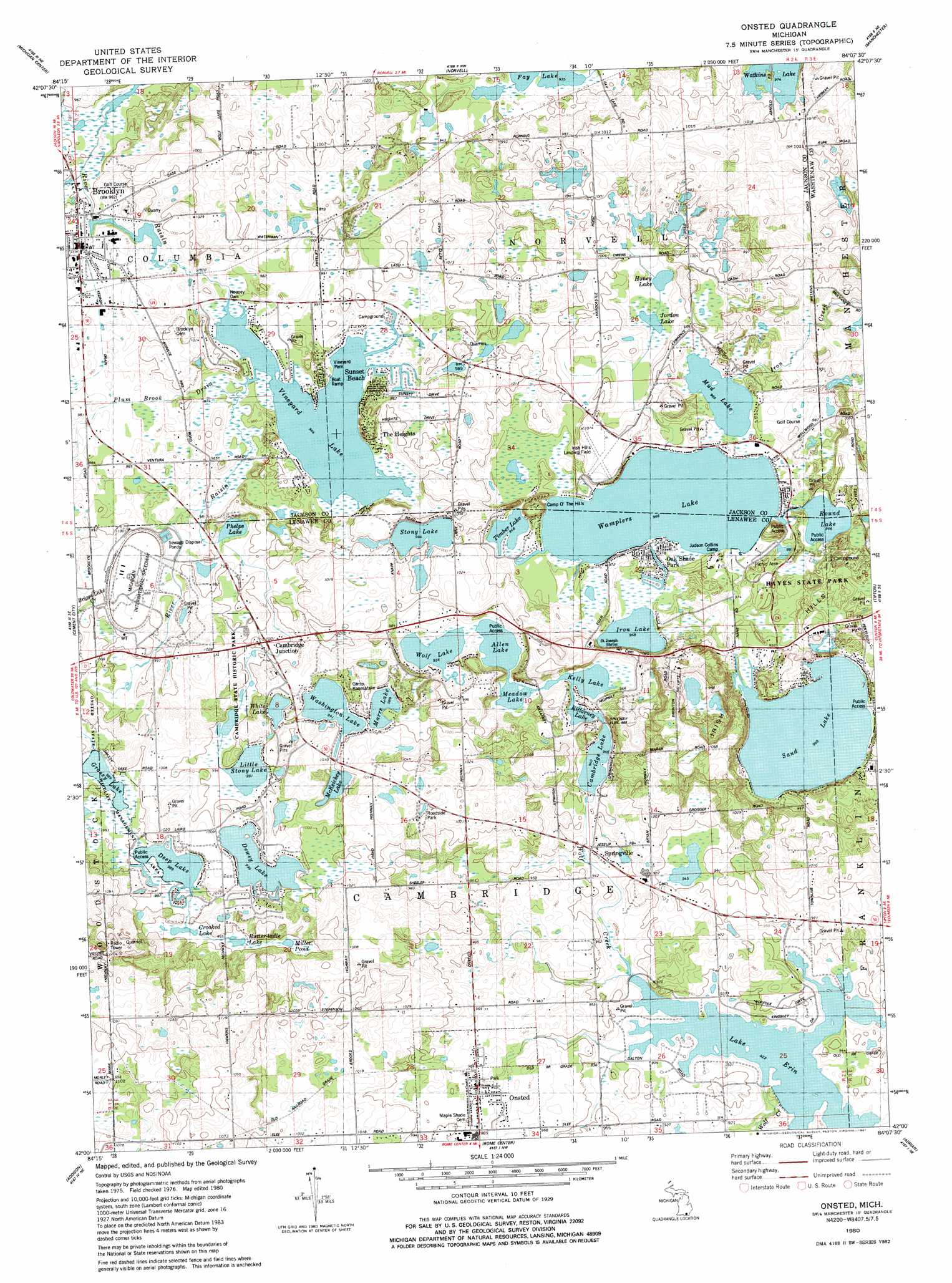
USGS Topo Quad 42084a2 - 1:24,000 scale
| Topo Map Name: | Onsted |
| USGS Topo Quad ID: | 42084a2 |
| Print Size: | ca. 21 1/4" wide x 27" high |
| Southeast Coordinates: | 42° N latitude / 84.125° W longitude |
| Map Center Coordinates: | 42.0625° N latitude / 84.1875° W longitude |
| U.S. State: | MI |
| Filename: | o42084a2.jpg |
| Download Map JPG Image: | Onsted topo map 1:24,000 scale |
| Map Type: | Topographic |
| Topo Series: | 7.5´ |
| Map Scale: | 1:24,000 |
| Source of Map Images: | United States Geological Survey (USGS) |
| Alternate Map Versions: |
Onsted MI 1980, updated 1981 Download PDF Buy paper map Onsted MI 1980, updated 1981 Download PDF Buy paper map Onsted MI 2011 Download PDF Buy paper map Onsted MI 2014 Download PDF Buy paper map Onsted MI 2017 Download PDF Buy paper map |
1:24,000 Topo Quads surrounding Onsted
Jackson North |
Gilletts Lake |
Grass Lake |
Chelsea |
Dexter |
Jackson South |
Michigan Center |
Norvell |
Manchester |
Bridgewater |
Somerset Center |
Cement City |
Onsted |
Tipton |
Tecumseh North |
Wheatland |
Addison |
Rome Center |
Adrian |
Tecumseh South |
Pittsford |
Hudson |
Clayton |
Jasper |
Palmyra |
> Back to 42084a1 at 1:100,000 scale
> Back to 42084a1 at 1:250,000 scale
> Back to U.S. Topo Maps home
Onsted topo map: Gazetteer
Onsted: Airports
Irish Hills Landing Field elevation 307m 1007′Loars Field Incorporated Airport elevation 300m 984′
Shamrock Field elevation 302m 990′
Onsted: Dams
Nooney Dam elevation 295m 967′Onsted: Lakes
Allen Lake elevation 291m 954′Butter-ladle Lake elevation 304m 997′
Cambridge Lake elevation 305m 1000′
Crooked Lake elevation 304m 997′
Deep Lake elevation 301m 987′
Dewey Lake elevation 304m 997′
Grassy Lake elevation 301m 987′
Honey Lake elevation 297m 974′
Iron Lake elevation 295m 967′
Jordan Lake elevation 297m 974′
Kelly Lake elevation 291m 954′
Killarney Lake elevation 291m 954′
Little Stony Lake elevation 302m 990′
Marrs Lake elevation 301m 987′
McKeichey Lake elevation 303m 994′
Meadow Lake elevation 291m 954′
Miller Pond elevation 304m 997′
Mud Lake elevation 294m 964′
Phelps Lake elevation 297m 974′
Round Lake elevation 294m 964′
Sand Lake elevation 295m 967′
Stony Lake elevation 303m 994′
Timber Lake elevation 295m 967′
Vineyard Lake elevation 294m 964′
Wamplers Lake elevation 294m 964′
Washington Lake elevation 302m 990′
Watkins Lake elevation 297m 974′
White Lake elevation 303m 994′
Wolf Lake elevation 291m 954′
Onsted: Parks
Cambridge State Historic Park elevation 304m 997′Deep Lake Recreational Park elevation 311m 1020′
Hayes State Park elevation 296m 971′
Onsted Park elevation 297m 974′
Saint Joseph's Church Historical Marker elevation 308m 1010′
Saint Joseph's Shrine Historical Marker elevation 308m 1010′
Vineyard Park elevation 300m 984′
Walker Tavern Historical Marker elevation 308m 1010′
Wooden Stone School Historical Marker elevation 341m 1118′
Onsted: Populated Places
Brooklyn elevation 303m 994′Cambridge Junction elevation 306m 1003′
Oak Shade Park elevation 297m 974′
Onsted elevation 301m 987′
Springville elevation 285m 935′
Sunset Beach elevation 298m 977′
The Heights elevation 304m 997′
Onsted: Post Offices
Cambridge Post Office (historical) elevation 305m 1000′Onsted Post Office elevation 301m 987′
Putnam Post Office (historical) elevation 300m 984′
Springville Post Office (historical) elevation 286m 938′
Onsted: Ranges
Irish Hills elevation 301m 987′Onsted: Streams
Briggs Lake Creek elevation 302m 990′Goose Creek elevation 286m 938′
Kedron Drain elevation 296m 971′
Plum Brook Drain elevation 295m 967′
Onsted digital topo map on disk
Buy this Onsted topo map showing relief, roads, GPS coordinates and other geographical features, as a high-resolution digital map file on DVD:
Northern Illinois, Northern Indiana & Southwestern Michigan
Buy digital topo maps: Northern Illinois, Northern Indiana & Southwestern Michigan