Springfield Topo Map Wisconsin
To zoom in, hover over the map of Springfield
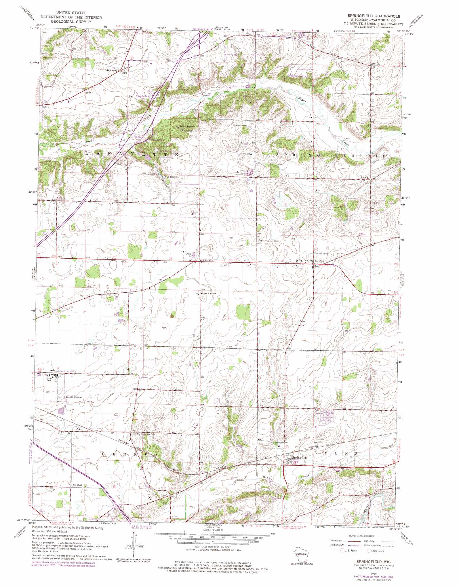
USGS Topo Quad 42088f4 - 1:24,000 scale
| Topo Map Name: | Springfield |
| USGS Topo Quad ID: | 42088f4 |
| Print Size: | ca. 21 1/4" wide x 27" high |
| Southeast Coordinates: | 42.625° N latitude / 88.375° W longitude |
| Map Center Coordinates: | 42.6875° N latitude / 88.4375° W longitude |
| U.S. State: | WI |
| Filename: | o42088f4.jpg |
| Download Map JPG Image: | Springfield topo map 1:24,000 scale |
| Map Type: | Topographic |
| Topo Series: | 7.5´ |
| Map Scale: | 1:24,000 |
| Source of Map Images: | United States Geological Survey (USGS) |
| Alternate Map Versions: |
Springfield WI 1960, updated 1962 Download PDF Buy paper map Springfield WI 1960, updated 1972 Download PDF Buy paper map Springfield WI 1960, updated 1977 Download PDF Buy paper map Springfield WI 2010 Download PDF Buy paper map Springfield WI 2013 Download PDF Buy paper map Springfield WI 2016 Download PDF Buy paper map |
1:24,000 Topo Quads surrounding Springfield
Rome |
Palmyra |
Eagle |
Genesee |
Muskego |
Whitewater |
Little Prairie |
East Troy |
Mukwonago |
Waterford |
Delavan |
Elkhorn |
Springfield |
Burlington |
Rochester |
Sharon |
Walworth |
Lake Geneva |
Genoa City |
Silver Lake |
Capron |
Harvard |
Hebron |
Richmond |
Fox Lake |
> Back to 42088e1 at 1:100,000 scale
> Back to 42088a1 at 1:250,000 scale
> Back to U.S. Topo Maps home
Springfield topo map: Gazetteer
Springfield: Airports
Barker Strip elevation 317m 1040′Fletcher Airport elevation 298m 977′
Lakeland Hospital Heliport elevation 317m 1040′
Mount Fuji Airport elevation 264m 866′
Plows and Props Airport elevation 254m 833′
Springfield: Dams
Elmer Droster E5299 Dam elevation 292m 958′Springfield: Populated Places
Bowers elevation 313m 1026′Spring Prairie elevation 309m 1013′
Springfield elevation 260m 853′
Springfield digital topo map on disk
Buy this Springfield topo map showing relief, roads, GPS coordinates and other geographical features, as a high-resolution digital map file on DVD:
Northern Illinois, Northern Indiana & Southwestern Michigan
Buy digital topo maps: Northern Illinois, Northern Indiana & Southwestern Michigan