Red Top Mountain Topo Map Wyoming
To zoom in, hover over the map of Red Top Mountain
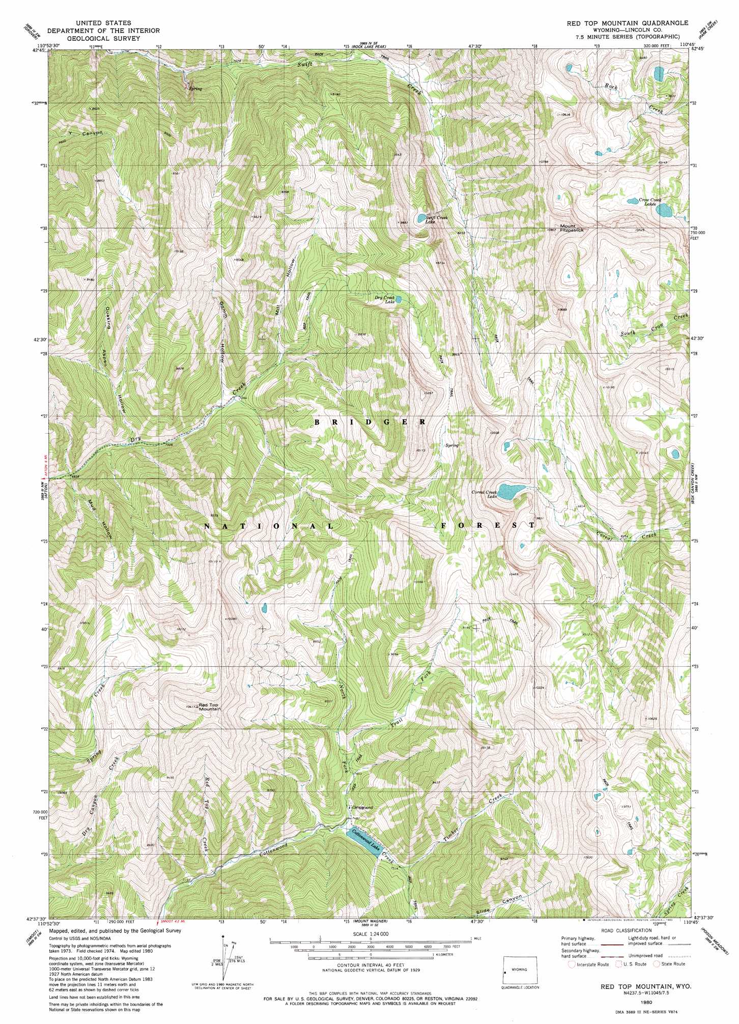
USGS Topo Quad 42110f7 - 1:24,000 scale
| Topo Map Name: | Red Top Mountain |
| USGS Topo Quad ID: | 42110f7 |
| Print Size: | ca. 21 1/4" wide x 27" high |
| Southeast Coordinates: | 42.625° N latitude / 110.75° W longitude |
| Map Center Coordinates: | 42.6875° N latitude / 110.8125° W longitude |
| U.S. State: | WY |
| Filename: | o42110f7.jpg |
| Download Map JPG Image: | Red Top Mountain topo map 1:24,000 scale |
| Map Type: | Topographic |
| Topo Series: | 7.5´ |
| Map Scale: | 1:24,000 |
| Source of Map Images: | United States Geological Survey (USGS) |
| Alternate Map Versions: |
Red Top Mountain WY 1980, updated 1980 Download PDF Buy paper map Red Top Mountain WY 1980, updated 1980 Download PDF Buy paper map Red Top Mountain WY 2012 Download PDF Buy paper map Red Top Mountain WY 2015 Download PDF Buy paper map |
| FStopo: | US Forest Service topo Red Top Mountain is available: Download FStopo PDF Download FStopo TIF |
1:24,000 Topo Quads surrounding Red Top Mountain
Thayne West |
Thayne East |
Man Peak |
Blind Bull Creek |
Lookout Mountain |
Auburn |
Grover |
Rock Lake Peak |
Park Creek |
Triple Peak |
Sage Valley |
Afton |
Red Top Mountain |
Box Canyon Creek |
Mount Schidler |
Elk Valley |
Smoot |
Mount Wagner |
Poison Meadows |
Wyoming Peak |
Giraffe Creek |
Salt Flat |
Porcupine Creek |
Graham Peak |
Mount Thompson |
> Back to 42110e1 at 1:100,000 scale
> Back to 42110a1 at 1:250,000 scale
> Back to U.S. Topo Maps home
Red Top Mountain topo map: Gazetteer
Red Top Mountain: Dams
Cottonwood Lake Dam elevation 2351m 7713′Red Top Mountain: Lakes
Corral Creek Lake elevation 2909m 9543′Cottonwood Lake elevation 2276m 7467′
Crow Creek Lakes elevation 2880m 9448′
Dry Creek Lake elevation 2706m 8877′
Swift Creek Lake elevation 2795m 9169′
Red Top Mountain: Mines
Afton Creek Mine elevation 2805m 9202′Red Top Mountain: Reservoirs
Cottonwood Lake elevation 2351m 7713′Red Top Mountain: Springs
Periodic Spring elevation 2243m 7358′Red Top Mountain: Streams
North Fork Cottonwood Creek elevation 2277m 7470′Red Top Creek elevation 2200m 7217′
Timber Creek elevation 2293m 7522′
Trail Fork elevation 2354m 7723′
Red Top Mountain: Summits
Mount Fitzpatrick elevation 3170m 10400′Red Top Mountain elevation 3166m 10387′
Red Top Mountain: Valleys
Gomm Hollow elevation 2209m 7247′Mill Hollow elevation 2302m 7552′
Mud Hollow elevation 2085m 6840′
Quaking Aspen Hollow elevation 2115m 6938′
Red Top Mountain digital topo map on disk
Buy this Red Top Mountain topo map showing relief, roads, GPS coordinates and other geographical features, as a high-resolution digital map file on DVD: