Pocatello North Topo Map Idaho
To zoom in, hover over the map of Pocatello North
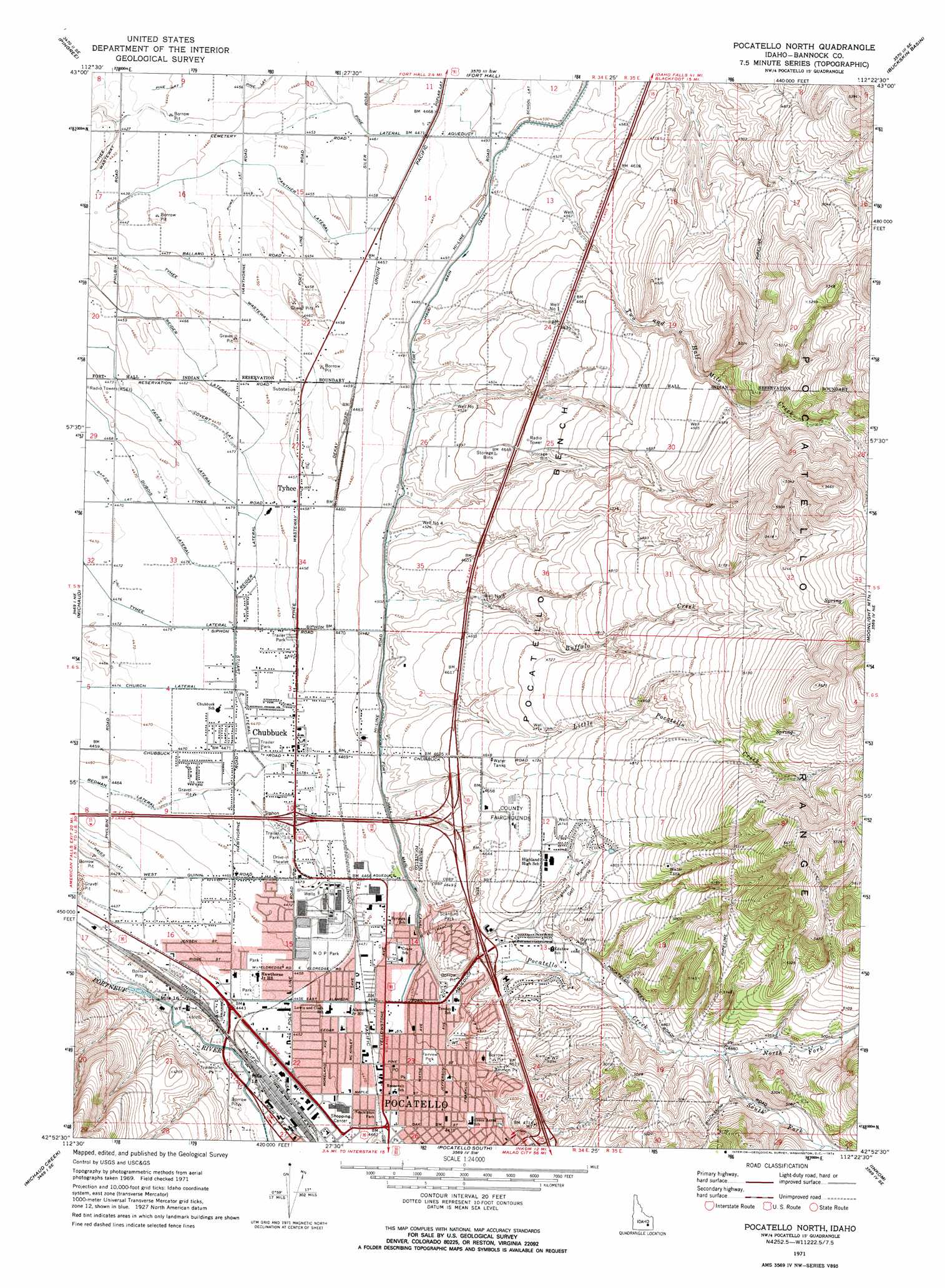
USGS Topo Quad 42112h4 - 1:24,000 scale
| Topo Map Name: | Pocatello North |
| USGS Topo Quad ID: | 42112h4 |
| Print Size: | ca. 21 1/4" wide x 27" high |
| Southeast Coordinates: | 42.875° N latitude / 112.375° W longitude |
| Map Center Coordinates: | 42.9375° N latitude / 112.4375° W longitude |
| U.S. State: | ID |
| Filename: | o42112h4.jpg |
| Download Map JPG Image: | Pocatello North topo map 1:24,000 scale |
| Map Type: | Topographic |
| Topo Series: | 7.5´ |
| Map Scale: | 1:24,000 |
| Source of Map Images: | United States Geological Survey (USGS) |
| Alternate Map Versions: |
Pocatello North ID 1971, updated 1974 Download PDF Buy paper map Pocatello North ID 1971, updated 1974 Download PDF Buy paper map Pocatello North ID 1974, updated 1975 Download PDF Buy paper map Pocatello North ID 2010 Download PDF Buy paper map Pocatello North ID 2013 Download PDF Buy paper map |
1:24,000 Topo Quads surrounding Pocatello North
Springfield Nw |
Rockford |
Moreland |
Blackfoot |
Lincoln Creek |
Springfield |
Pingree |
Fort Hall |
Buckskin Basin |
Yandell Springs |
Schiller |
Michaud |
Pocatello North |
Moonlight Mountain |
South Putnam Mountain |
Wheatgrass Bench |
Michaud Creek |
Pocatello South |
Inkom |
Bonneville Peak |
Sawmill Creek |
Flatiron Hill |
Clifton Creek |
Scout Mountain |
Mccammon |
> Back to 42112e1 at 1:100,000 scale
> Back to 42112a1 at 1:250,000 scale
> Back to U.S. Topo Maps home
Pocatello North topo map: Gazetteer
Pocatello North: Benches
Pocatello Bench elevation 1424m 4671′Pocatello North: Canals
Baker Lateral elevation 1363m 4471′Covet Lateral elevation 1364m 4475′
DuBois Lateral elevation 1361m 4465′
Facer Lateral elevation 1364m 4475′
Panther Lateral elevation 1359m 4458′
Pear Lateral elevation 1360m 4461′
Redman Lateral elevation 1364m 4475′
Reider Lateral elevation 1363m 4471′
Stuart Lateral elevation 1364m 4475′
Tyhee Wasteway elevation 1357m 4452′
Pocatello North: Dams
Simplot Effluent Irrigation Dam elevation 1420m 4658′Pocatello North: Parks
Ammon Park elevation 1405m 4609′Bonneville Park elevation 1433m 4701′
Fairview Park elevation 1371m 4498′
Freckleton Park elevation 1361m 4465′
N O P Park elevation 1362m 4468′
Scardino Park elevation 1390m 4560′
Stuart Park elevation 1365m 4478′
Pocatello North: Populated Places
Alameda elevation 1367m 4484′Chubbuck elevation 1363m 4471′
Tyhee elevation 1360m 4461′
Pocatello North: Streams
Buffalo Creek elevation 1374m 4507′Little Pocatello Creek elevation 1384m 4540′
North Fork Pocatello Creek elevation 1486m 4875′
Pocatello Creek elevation 1347m 4419′
South Fork Pocatello Creek elevation 1486m 4875′
Two and a Half Mile Creek elevation 1384m 4540′
Pocatello North: Wells
Well Number 1 elevation 1423m 4668′Well Number 3 elevation 1381m 4530′
Well Number 4 elevation 1384m 4540′
Well Number 5 elevation 1395m 4576′
Pocatello North digital topo map on disk
Buy this Pocatello North topo map showing relief, roads, GPS coordinates and other geographical features, as a high-resolution digital map file on DVD: