Hopper Gulch Topo Map Idaho
To zoom in, hover over the map of Hopper Gulch
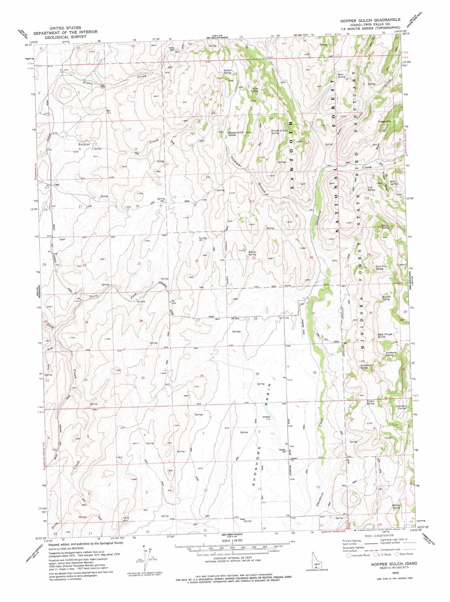
USGS Topo Quad 42114b4 - 1:24,000 scale
| Topo Map Name: | Hopper Gulch |
| USGS Topo Quad ID: | 42114b4 |
| Print Size: | ca. 21 1/4" wide x 27" high |
| Southeast Coordinates: | 42.125° N latitude / 114.375° W longitude |
| Map Center Coordinates: | 42.1875° N latitude / 114.4375° W longitude |
| U.S. State: | ID |
| Filename: | o42114b4.jpg |
| Download Map JPG Image: | Hopper Gulch topo map 1:24,000 scale |
| Map Type: | Topographic |
| Topo Series: | 7.5´ |
| Map Scale: | 1:24,000 |
| Source of Map Images: | United States Geological Survey (USGS) |
| Alternate Map Versions: |
Hopper Gulch ID 1978, updated 1978 Download PDF Buy paper map Hopper Gulch ID 2001, updated 2006 Download PDF Buy paper map Hopper Gulch ID 2011 Download PDF Buy paper map Hopper Gulch ID 2013 Download PDF Buy paper map |
| FStopo: | US Forest Service topo Hopper Gulch is available: Download FStopo PDF Download FStopo TIF |
1:24,000 Topo Quads surrounding Hopper Gulch
Berger Butte |
Berger |
Hub Butte |
Stricker Butte |
Murtaugh |
Hollister Sw |
Hollister |
Mcmullen Basin |
Grand View Peak |
Rams Horn Ridge |
Salmon Butte |
Rogerson |
Hopper Gulch |
Pike Mountain |
Trapper Peak |
Norton Canyon |
Magic Hot Springs |
Big Creek Ranch |
Timber Butte |
Mahogany Butte |
Jackpot |
East Of Jackpot |
Gollaher Mountain |
Stratton Spring |
Fivemile Gulch |
> Back to 42114a1 at 1:100,000 scale
> Back to 42114a1 at 1:250,000 scale
> Back to U.S. Topo Maps home
Hopper Gulch topo map: Gazetteer
Hopper Gulch: Springs
Bone Spring elevation 1907m 6256′Browns Spring elevation 1909m 6263′
Buck Trough Spring elevation 1904m 6246′
Cow Spring elevation 1872m 6141′
Cub Spring elevation 1848m 6062′
Fourth of July Spring elevation 1885m 6184′
Hopper Gulch Spring elevation 1872m 6141′
Junction Spring elevation 1874m 6148′
Lone Pine Spring elevation 1870m 6135′
Nelson Spring elevation 1811m 5941′
Northeast Spring elevation 1926m 6318′
Parker Spring elevation 1853m 6079′
Section Spring elevation 1901m 6236′
Soldier Spring elevation 1887m 6190′
Southeast Spring elevation 1829m 6000′
Stratton Spring elevation 1831m 6007′
Whir Spring elevation 1833m 6013′
Whittle Spring elevation 1813m 5948′
Hopper Gulch: Streams
North Fork Deep Creek elevation 1617m 5305′Pole Camp Creek elevation 1784m 5853′
South Fork Deep Creek elevation 1626m 5334′
Hopper Gulch: Valleys
Arnolds Gulch elevation 1803m 5915′Bear Gulch elevation 1794m 5885′
Hopper Gulch elevation 1787m 5862′
Hopper Gulch: Wells
Alvins Well elevation 1724m 5656′Hopper Gulch digital topo map on disk
Buy this Hopper Gulch topo map showing relief, roads, GPS coordinates and other geographical features, as a high-resolution digital map file on DVD: