Horse Prairie Topo Map Oregon
To zoom in, hover over the map of Horse Prairie
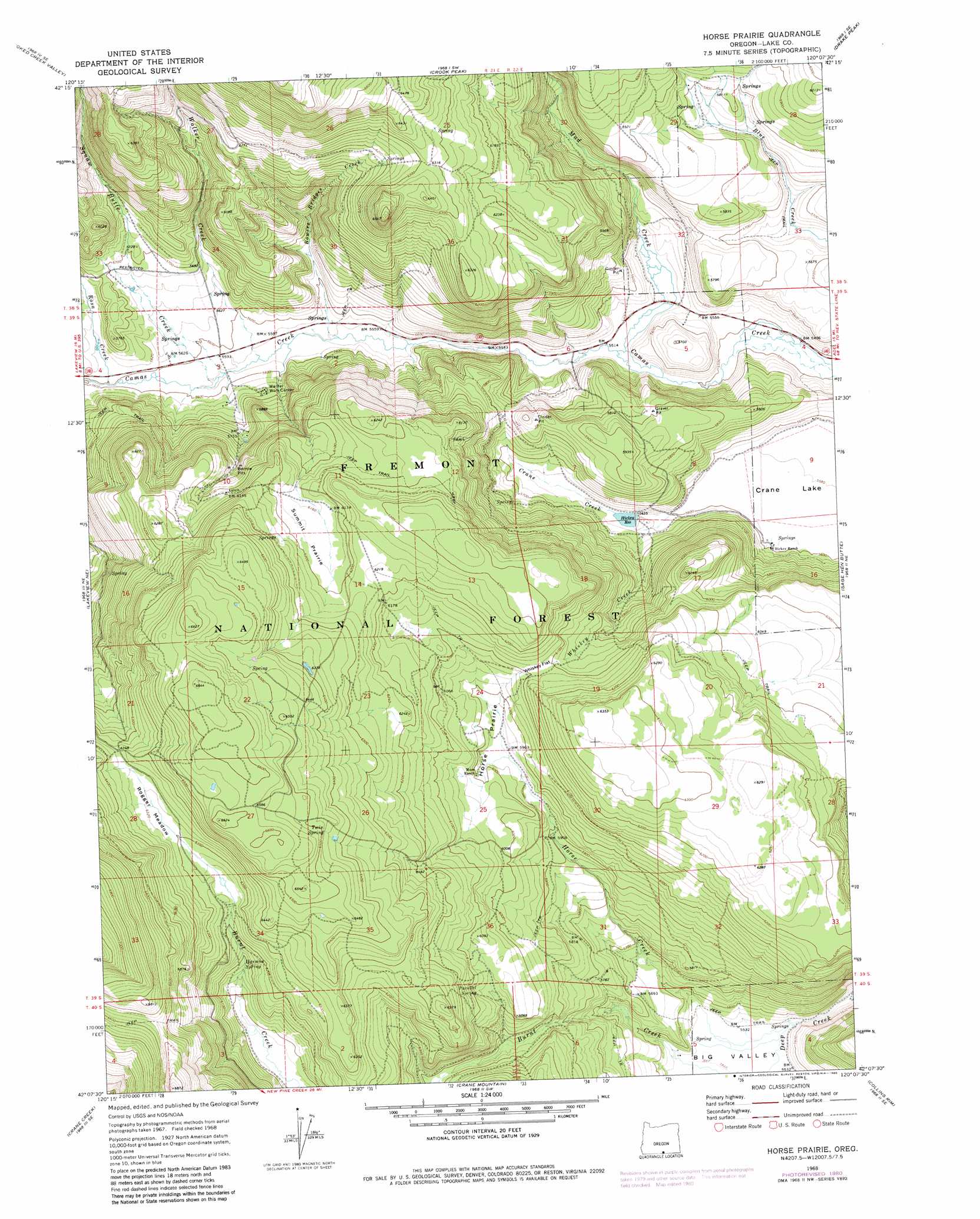
USGS Topo Quad 42120b2 - 1:24,000 scale
| Topo Map Name: | Horse Prairie |
| USGS Topo Quad ID: | 42120b2 |
| Print Size: | ca. 21 1/4" wide x 27" high |
| Southeast Coordinates: | 42.125° N latitude / 120.125° W longitude |
| Map Center Coordinates: | 42.1875° N latitude / 120.1875° W longitude |
| U.S. State: | OR |
| Filename: | o42120b2.jpg |
| Download Map JPG Image: | Horse Prairie topo map 1:24,000 scale |
| Map Type: | Topographic |
| Topo Series: | 7.5´ |
| Map Scale: | 1:24,000 |
| Source of Map Images: | United States Geological Survey (USGS) |
| Alternate Map Versions: |
Horse Prairie OR 1968, updated 1972 Download PDF Buy paper map Horse Prairie OR 1968, updated 1980 Download PDF Buy paper map Horse Prairie OR 2011 Download PDF Buy paper map Horse Prairie OR 2014 Download PDF Buy paper map |
| FStopo: | US Forest Service topo Horse Prairie is available: Download FStopo PDF Download FStopo TIF |
1:24,000 Topo Quads surrounding Horse Prairie
Clover Flat |
Valley Falls |
Little Honey Creek |
Drake Peak Ne |
Plush |
Big Baldy |
Crooked Creek Valley |
Crook Peak |
Drake Peak |
Priday Reservoir |
Lakeview Airport |
Lakeview |
Horse Prairie |
Sage Hen Butte |
Adel |
West Side |
Crane Creek |
Crane Mountain |
Collins Rim |
May Lake |
West Of Willow Ranch |
Willow Ranch |
Mount Bidwell |
Lake Annie |
Barrel Springs |
> Back to 42120a1 at 1:100,000 scale
> Back to 42120a1 at 1:250,000 scale
> Back to U.S. Topo Maps home
Horse Prairie topo map: Gazetteer
Horse Prairie: Dams
Hickey Dam elevation 1718m 5636′Horse Prairie: Flats
Crane Lake elevation 1702m 5583′Horse Prairie elevation 1822m 5977′
Rogger Meadow elevation 1926m 6318′
Summit Prairie elevation 1883m 6177′
Whiskey Flat elevation 1864m 6115′
Horse Prairie: Reservoirs
Hickey Reservoir elevation 1719m 5639′Horse Prairie: Springs
Harmon Spring elevation 1856m 6089′Parallel Spring elevation 1844m 6049′
Twin Spring elevation 1968m 6456′
Horse Prairie: Streams
Bowers Bridges Creek elevation 1695m 5561′Horse Creek elevation 1683m 5521′
Mud Creek elevation 1681m 5515′
Rosa Creek elevation 1708m 5603′
Squaw Butte Creek elevation 1702m 5583′
Walker Creek elevation 1699m 5574′
Whiskey Creek elevation 1716m 5629′
Horse Prairie: Valleys
Big Valley elevation 1685m 5528′Horse Prairie digital topo map on disk
Buy this Horse Prairie topo map showing relief, roads, GPS coordinates and other geographical features, as a high-resolution digital map file on DVD: