Obenchain Mountain Topo Map Oregon
To zoom in, hover over the map of Obenchain Mountain
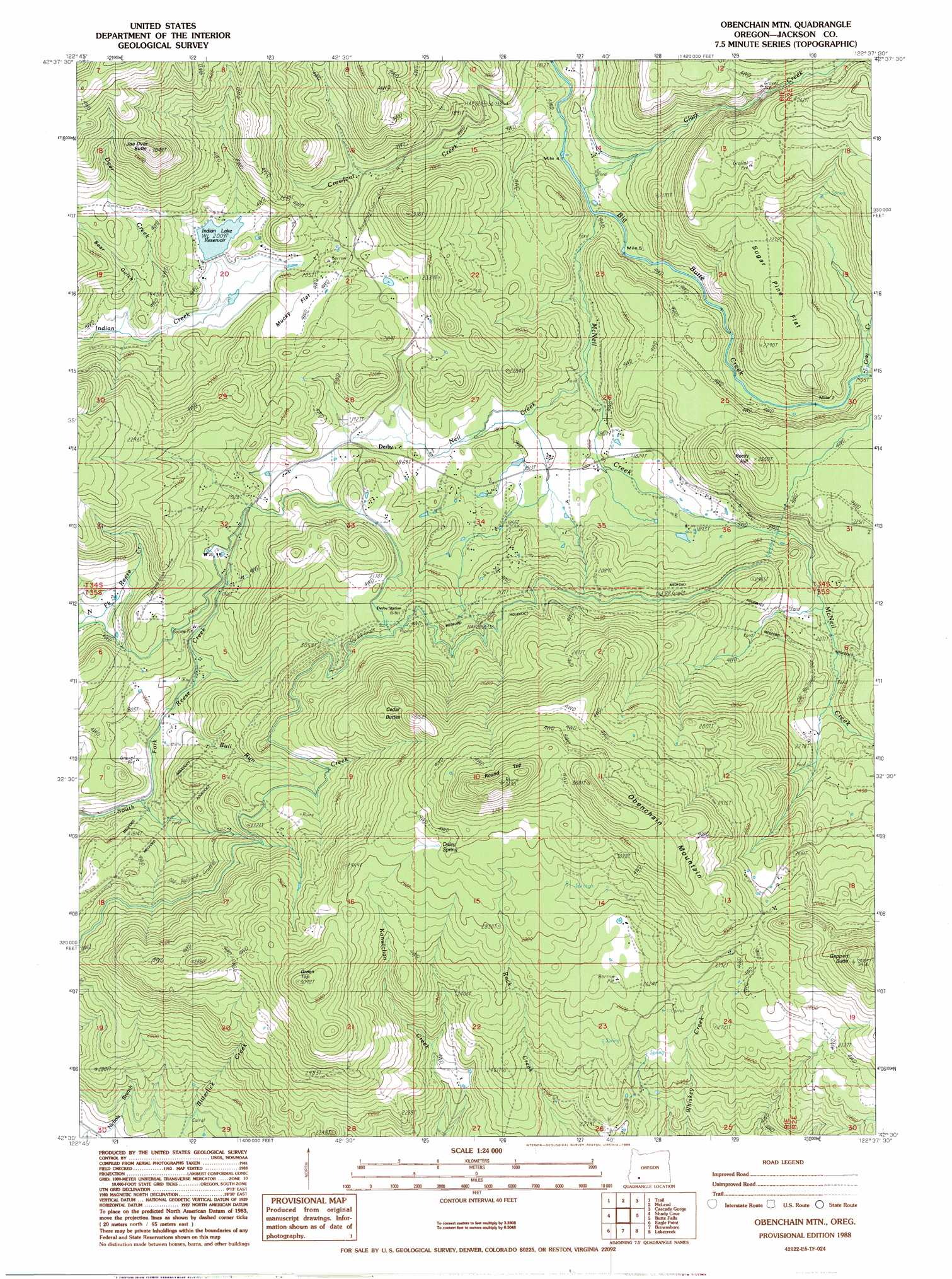
USGS Topo Quad 42122e6 - 1:24,000 scale
| Topo Map Name: | Obenchain Mountain |
| USGS Topo Quad ID: | 42122e6 |
| Print Size: | ca. 21 1/4" wide x 27" high |
| Southeast Coordinates: | 42.5° N latitude / 122.625° W longitude |
| Map Center Coordinates: | 42.5625° N latitude / 122.6875° W longitude |
| U.S. State: | OR |
| Filename: | o42122e6.jpg |
| Download Map JPG Image: | Obenchain Mountain topo map 1:24,000 scale |
| Map Type: | Topographic |
| Topo Series: | 7.5´ |
| Map Scale: | 1:24,000 |
| Source of Map Images: | United States Geological Survey (USGS) |
| Alternate Map Versions: |
Obenchain Mtn OR 1988, updated 1988 Download PDF Buy paper map Obenchain Mountain OR 2011 Download PDF Buy paper map Obenchain Mountain OR 2014 Download PDF Buy paper map |
1:24,000 Topo Quads surrounding Obenchain Mountain
Richter Mountain |
Ragsdale Butte |
Sugarpine Creek |
Whetstone Point |
Prospect North |
Cleveland Ridge |
Trail |
Mcleod |
Cascade Gorge |
Prospect South |
Boswell Mountain |
Shady Cove |
Obenchain Mountain |
Butte Falls |
Big Butte Springs |
Sams Valley |
Eagle Point |
Brownsboro |
Lakecreek |
Willow Lake |
Medford West |
Medford East |
Rio Canyon |
Grizzly Peak |
Robinson Butte |
> Back to 42122e1 at 1:100,000 scale
> Back to 42122a1 at 1:250,000 scale
> Back to U.S. Topo Maps home
Obenchain Mountain topo map: Gazetteer
Obenchain Mountain: Canals
Eagle Point Irrigation Canal elevation 693m 2273′Obenchain Mountain: Flats
Mucky Flat elevation 629m 2063′Sugar Pine Flat elevation 698m 2290′
Obenchain Mountain: Populated Places
Derby (historical) elevation 575m 1886′Edsalla (historical) elevation 697m 2286′
Obenchain Mountain: Post Offices
Derby Post Office (historical) elevation 575m 1886′Obenchain Mountain: Reservoirs
Indian Lake Reservoir elevation 613m 2011′Obenchain Mountain: Springs
Daley Spring elevation 878m 2880′Deer Lick Spring elevation 524m 1719′
Obenchain Mountain: Streams
Bull Run Creek elevation 520m 1706′Cattail Creek elevation 627m 2057′
Clark Creek elevation 509m 1669′
Crowfoot Creek elevation 499m 1637′
Deer Creek elevation 578m 1896′
Gray Creek elevation 586m 1922′
McNeil Creek elevation 512m 1679′
Neil Creek elevation 536m 1758′
Quartz Creek elevation 544m 1784′
Obenchain Mountain: Summits
Cedar Buttes elevation 924m 3031′Geppert Butte elevation 1044m 3425′
Green Top elevation 941m 3087′
Joe Dyer Butte elevation 929m 3047′
Obenchain Mountain elevation 1100m 3608′
Rocky Hill elevation 775m 2542′
Round Top elevation 1121m 3677′
Obenchain Mountain: Valleys
Bear Gulch elevation 576m 1889′Obenchain Mountain digital topo map on disk
Buy this Obenchain Mountain topo map showing relief, roads, GPS coordinates and other geographical features, as a high-resolution digital map file on DVD: