Cedar Springs Mountain Topo Map Oregon
To zoom in, hover over the map of Cedar Springs Mountain
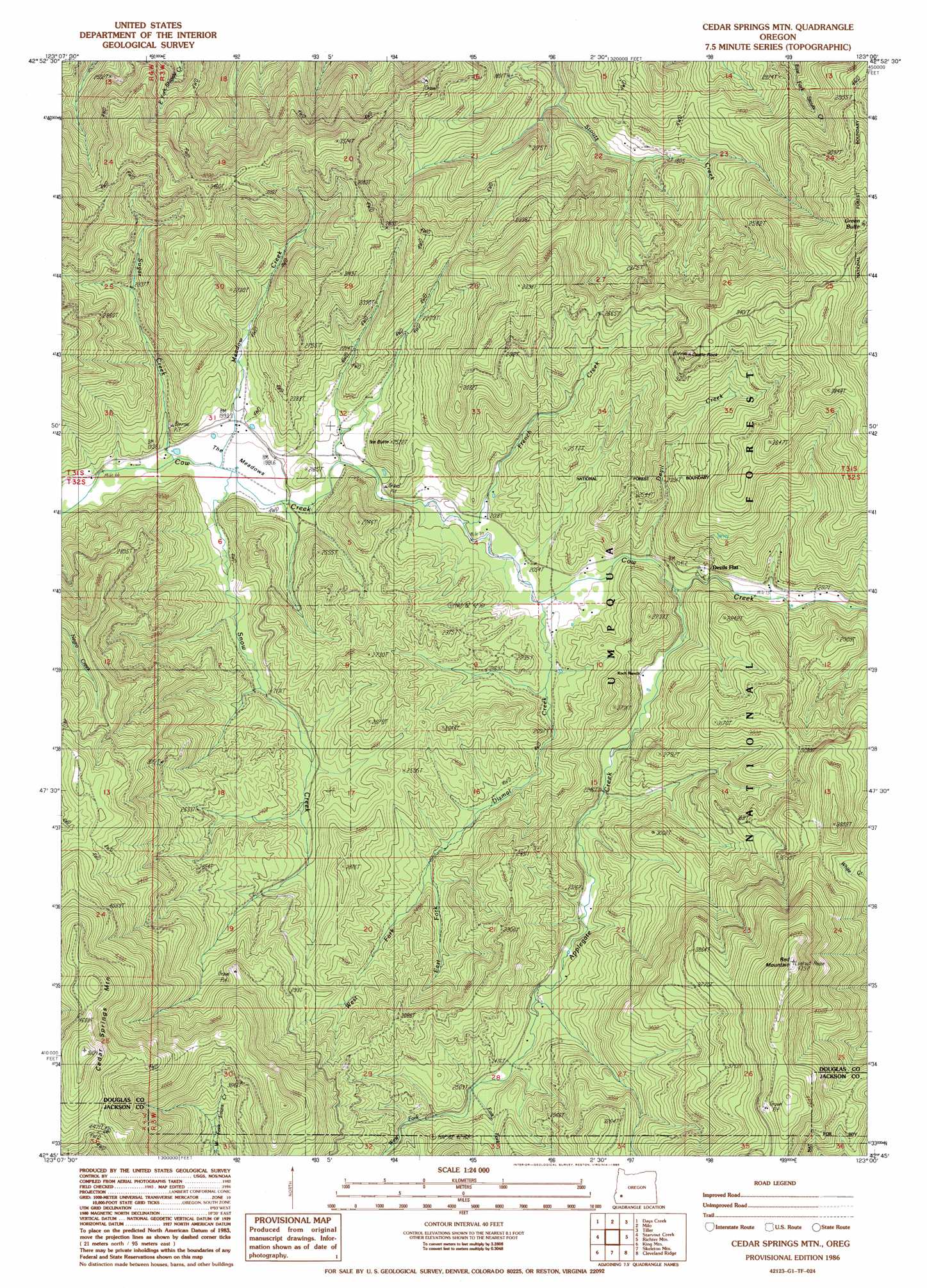
USGS Topo Quad 42123g1 - 1:24,000 scale
| Topo Map Name: | Cedar Springs Mountain |
| USGS Topo Quad ID: | 42123g1 |
| Print Size: | ca. 21 1/4" wide x 27" high |
| Southeast Coordinates: | 42.75° N latitude / 123° W longitude |
| Map Center Coordinates: | 42.8125° N latitude / 123.0625° W longitude |
| U.S. State: | OR |
| Filename: | o42123g1.jpg |
| Download Map JPG Image: | Cedar Springs Mountain topo map 1:24,000 scale |
| Map Type: | Topographic |
| Topo Series: | 7.5´ |
| Map Scale: | 1:24,000 |
| Source of Map Images: | United States Geological Survey (USGS) |
| Alternate Map Versions: |
Cedar Springs Mtn OR 1986, updated 1986 Download PDF Buy paper map Cedar Springs Mountain OR 1998, updated 2000 Download PDF Buy paper map Cedar Springs Mountain OR 2011 Download PDF Buy paper map Cedar Springs Mountain OR 2014 Download PDF Buy paper map |
| FStopo: | US Forest Service topo Cedar Springs Mountain is available: Download FStopo PDF Download FStopo TIF |
1:24,000 Topo Quads surrounding Cedar Springs Mountain
Myrtle Creek |
Dodson Butte |
White Rock |
Deadman Mountain |
Dumont Creek |
Canyonville |
Days Creek |
Milo |
Tiller |
Pickett Butte |
Quines Creek |
Starvout Creek |
Cedar Springs Mountain |
Richter Mountain |
Ragsdale Butte |
Golden |
King Mountain |
Skeleton Mountain |
Cleveland Ridge |
Trail |
Sexton Mountain |
Wimer |
Mcconville Peak |
Boswell Mountain |
Shady Cove |
> Back to 42123e1 at 1:100,000 scale
> Back to 42122a1 at 1:250,000 scale
> Back to U.S. Topo Maps home
Cedar Springs Mountain topo map: Gazetteer
Cedar Springs Mountain: Flats
Devils Flat elevation 688m 2257′The Meadows elevation 598m 1961′
Cedar Springs Mountain: Pillars
Castle Rock elevation 1049m 3441′Cedar Springs Mountain: Post Offices
Binger Post Office (historical) elevation 595m 1952′Cedar Springs Mountain: Streams
Applegate Creek elevation 635m 2083′Copper Creek elevation 684m 2244′
Devil Creek elevation 627m 2057′
Dismal Creek elevation 617m 2024′
East Fork Applegate Creek elevation 765m 2509′
East Fork Dismal Creek elevation 675m 2214′
Elk Creek elevation 587m 1925′
French Creek elevation 607m 1991′
Granite Creek elevation 614m 2014′
Jack Creek elevation 731m 2398′
Maple Creek elevation 598m 1961′
Meadow Creek elevation 587m 1925′
North Fork Dismal Creek elevation 629m 2063′
Snow Creek elevation 588m 1929′
Steamboat Creek elevation 587m 1925′
Sugar Creek elevation 587m 1925′
West Fork Applegate Creek elevation 765m 2509′
West Fork Dismal Creek elevation 679m 2227′
Cedar Springs Mountain: Summits
Cedar Springs Mountain elevation 1552m 5091′Green Butte elevation 1184m 3884′
Ike Butte elevation 765m 2509′
Red Mountain elevation 1449m 4753′
Cedar Springs Mountain: Trails
Canyon Number Three Trail elevation 901m 2956′Red Mountain Trail elevation 1115m 3658′
Cedar Springs Mountain: Valleys
Cow Creek Gorge elevation 658m 2158′Cedar Springs Mountain digital topo map on disk
Buy this Cedar Springs Mountain topo map showing relief, roads, GPS coordinates and other geographical features, as a high-resolution digital map file on DVD: