Rathbun Ranch Topo Map Wyoming
To zoom in, hover over the map of Rathbun Ranch
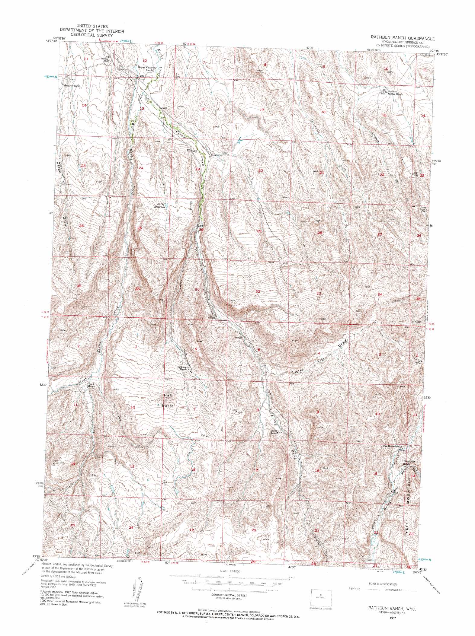
USGS Topo Quad 43107e7 - 1:24,000 scale
| Topo Map Name: | Rathbun Ranch |
| USGS Topo Quad ID: | 43107e7 |
| Print Size: | ca. 21 1/4" wide x 27" high |
| Southeast Coordinates: | 43.5° N latitude / 107.75° W longitude |
| Map Center Coordinates: | 43.5625° N latitude / 107.8125° W longitude |
| U.S. State: | WY |
| Filename: | o43107e7.jpg |
| Download Map JPG Image: | Rathbun Ranch topo map 1:24,000 scale |
| Map Type: | Topographic |
| Topo Series: | 7.5´ |
| Map Scale: | 1:24,000 |
| Source of Map Images: | United States Geological Survey (USGS) |
| Alternate Map Versions: |
Rathbun Ranch WY 1952, updated 1953 Download PDF Buy paper map Rathbun Ranch WY 1957, updated 1958 Download PDF Buy paper map Rathbun Ranch WY 2012 Download PDF Buy paper map Rathbun Ranch WY 2015 Download PDF Buy paper map |
1:24,000 Topo Quads surrounding Rathbun Ranch
Cedar Mountain |
Zimmerman Buttes |
Henry Draw |
Wagon Prong |
Deadline Draw |
Red Hole |
Coyote Hill |
Packsaddle Creek |
Bader Draw |
Sand Point |
Devil Slide |
Blue Hill |
Rathbun Ranch |
Bull Mountain |
Battle Mountain |
Birdseye Pass |
Guffy Peak |
De Pass |
Arapahoe Butte |
Cottonwood Pass |
Bonneville |
Picard Ranch |
Gates Butte |
Lysite |
Lysite Se |
> Back to 43107e1 at 1:100,000 scale
> Back to 43106a1 at 1:250,000 scale
> Back to U.S. Topo Maps home
Rathbun Ranch topo map: Gazetteer
Rathbun Ranch: Dams
Gardner Dam elevation 1577m 5173′Rathbun Irrigation Number 1 Dam elevation 1868m 6128′
Rathbun Ranch: Reservoirs
Gardner Reservoir elevation 1577m 5173′Kirby Reservoir elevation 1610m 5282′
Rathbun Irrigation Number 1 Reservoir elevation 1868m 6128′
Rathbun Ranch: Streams
Ackles Fork elevation 1564m 5131′Dry Fork elevation 1658m 5439′
East Kirby Creek elevation 1493m 4898′
Maimes Creek elevation 1798m 5898′
Reed Creek elevation 1665m 5462′
West Kirby Creek elevation 1494m 4901′
Rathbun Ranch: Summits
Hall Butte elevation 1845m 6053′Rathbun Ranch: Valleys
Little V-H Draw elevation 1666m 5465′Rathbun Ranch digital topo map on disk
Buy this Rathbun Ranch topo map showing relief, roads, GPS coordinates and other geographical features, as a high-resolution digital map file on DVD:
Eastern Wyoming & Western South Dakota
Buy digital topo maps: Eastern Wyoming & Western South Dakota