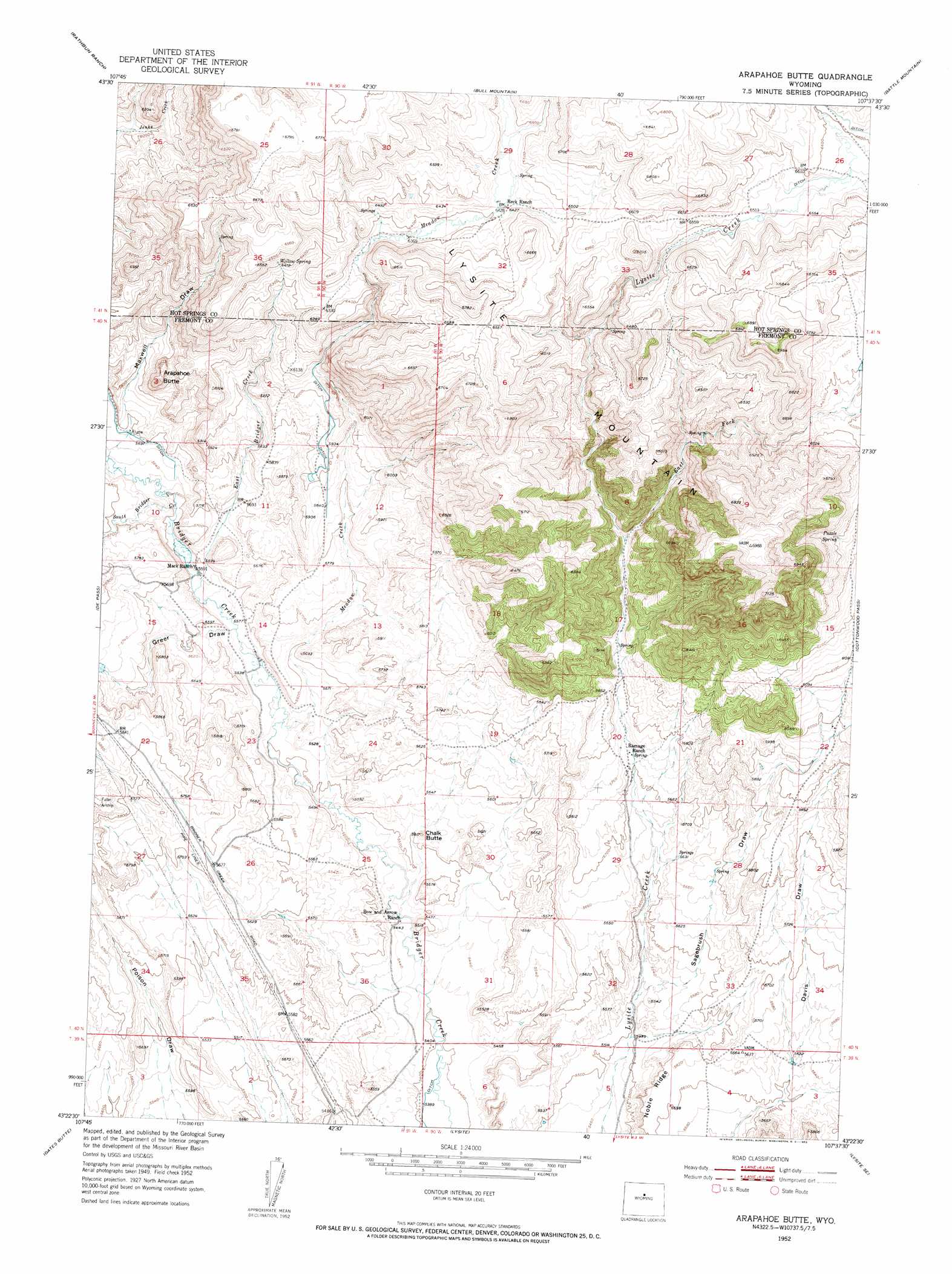
Arapahoe Butte Topo Map Wyoming
To zoom in, hover over the map of Arapahoe Butte
USGS Topo Quad 43107d6 - 1:24,000 scale
| Topo Map Name: | Arapahoe Butte |
| USGS Topo Quad ID: | 43107d6 |
| Print Size: | ca. 21 1/4" wide x 27" high |
| Southeast Coordinates: | 43.375° N latitude / 107.625° W longitude |
| Map Center Coordinates: | 43.4375° N latitude / 107.6875° W longitude |
| U.S. State: | WY |
| Filename: | o43107d6.jpg |
| Download Map JPG Image: | Arapahoe Butte topo map 1:24,000 scale |
| Map Type: | Topographic |
| Topo Series: | 7.5´ |
| Map Scale: | 1:24,000 |
| Source of Map Images: | United States Geological Survey (USGS) |
| Alternate Map Versions: |
Arapahoe Butte WY 1952, updated 1953 Download PDF Buy paper map Arapahoe Butte WY 2012 Download PDF Buy paper map Arapahoe Butte WY 2015 Download PDF Buy paper map |
1:24,000 Topo Quads surrounding Arapahoe Butte
Coyote Hill |
Packsaddle Creek |
Bader Draw |
Sand Point |
Lightning Ridge |
Blue Hill |
Rathbun Ranch |
Bull Mountain |
Battle Mountain |
Cornell Gulch |
Guffy Peak |
De Pass |
Arapahoe Butte |
Cottonwood Pass |
Sioux Pass |
Picard Ranch |
Gates Butte |
Lysite |
Lysite Se |
Badwater |
Ocla Draw |
Squaw Butte Ne |
Moneta |
Madden |
Arminto Nw |
> Back to 43107a1 at 1:100,000 scale
> Back to 43106a1 at 1:250,000 scale
> Back to U.S. Topo Maps home
Arapahoe Butte topo map: Gazetteer
Arapahoe Butte: Mines
Mag Number One Mine elevation 1728m 5669′Arapahoe Butte: Springs
Puzzle Spring elevation 1945m 6381′Willow Spring elevation 1964m 6443′
Arapahoe Butte: Streams
East Bridger Creek elevation 1702m 5583′East Fork Lysite Creek elevation 1835m 6020′
Meadow Creek elevation 1683m 5521′
South Bridger Creek elevation 1706m 5597′
Arapahoe Butte: Summits
Arapahoe Butte elevation 1856m 6089′Chalk Butte elevation 1686m 5531′
Arapahoe Butte: Valleys
Greer Draw elevation 1692m 5551′Maxwell Draw elevation 1720m 5643′
Sagebrush Draw elevation 1686m 5531′
Arapahoe Butte digital topo map on disk
Buy this Arapahoe Butte topo map showing relief, roads, GPS coordinates and other geographical features, as a high-resolution digital map file on DVD:
Eastern Wyoming & Western South Dakota
Buy digital topo maps: Eastern Wyoming & Western South Dakota