Rocky Bar Topo Map Idaho
To zoom in, hover over the map of Rocky Bar
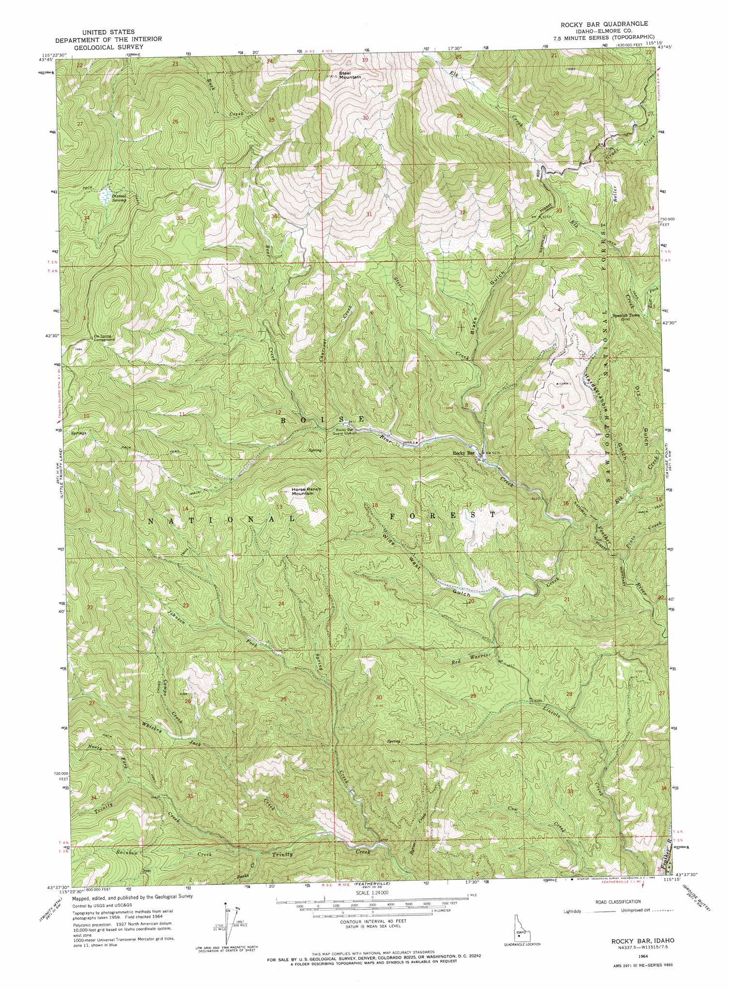
USGS Topo Quad 43115f3 - 1:24,000 scale
| Topo Map Name: | Rocky Bar |
| USGS Topo Quad ID: | 43115f3 |
| Print Size: | ca. 21 1/4" wide x 27" high |
| Southeast Coordinates: | 43.625° N latitude / 115.25° W longitude |
| Map Center Coordinates: | 43.6875° N latitude / 115.3125° W longitude |
| U.S. State: | ID |
| Filename: | o43115f3.jpg |
| Download Map JPG Image: | Rocky Bar topo map 1:24,000 scale |
| Map Type: | Topographic |
| Topo Series: | 7.5´ |
| Map Scale: | 1:24,000 |
| Source of Map Images: | United States Geological Survey (USGS) |
| Alternate Map Versions: |
Rocky Bar ID 1964, updated 1966 Download PDF Buy paper map Rocky Bar ID 2011 Download PDF Buy paper map Rocky Bar ID 2013 Download PDF Buy paper map |
| FStopo: | US Forest Service topo Rocky Bar is available: Download FStopo PDF Download FStopo TIF |
1:24,000 Topo Quads surrounding Rocky Bar
Big Owl Creek |
Bear River |
Swanholm Peak |
Nahneke Mountain |
Mount Everly |
Barber Flat |
Grand Mountain |
Phifer Creek |
Atlanta West |
Atlanta East |
Sheep Creek |
Little Trinity Lake |
Rocky Bar |
Cayuse Point |
Ross Peak |
Prairie |
Trinity Mountain |
Featherville |
Grouse Butte |
Jumbo Mountain |
Cathedral Rocks |
House Mountain |
Pine |
Sprout Mountain |
Deer Mountain |
> Back to 43115e1 at 1:100,000 scale
> Back to 43114a1 at 1:250,000 scale
> Back to U.S. Topo Maps home
Rocky Bar topo map: Gazetteer
Rocky Bar: Populated Places
Rocky Bar elevation 1606m 5269′Spanish Town (historical) elevation 1687m 5534′
Rocky Bar: Post Offices
Rocky Bar Post Office (historical) elevation 1606m 5269′Rocky Bar: Streams
Bear Creek elevation 1584m 5196′Boiler Grade Creek elevation 1772m 5813′
Byron Creek elevation 1489m 4885′
Campo Creek elevation 1668m 5472′
Charcoal Creek elevation 1647m 5403′
East Fork Elk Creek elevation 1697m 5567′
Elk Creek elevation 1571m 5154′
Johnson Fork elevation 1624m 5328′
North Fork Steel Creek elevation 1705m 5593′
North Fork Trinity Creek elevation 1760m 5774′
Parks Creek elevation 1589m 5213′
Pinto Creek elevation 1515m 4970′
Rainbow Creek elevation 1627m 5337′
Red Warrior Creek elevation 1551m 5088′
Sand Creek elevation 1655m 5429′
Spring Creek elevation 1507m 4944′
Steel Creek elevation 1590m 5216′
Whiskey Jack Creek elevation 1538m 5045′
Rocky Bar: Summits
Horse Ranch Mountain elevation 2056m 6745′Steel Mountain elevation 2965m 9727′
Rocky Bar: Swamps
Dismal Swamp elevation 2022m 6633′Rocky Bar: Valleys
Blake Gulch elevation 1626m 5334′Dry Gulch elevation 1604m 5262′
Hardscrabble Gulch elevation 1577m 5173′
Wide West Gulch elevation 1599m 5246′
Rocky Bar digital topo map on disk
Buy this Rocky Bar topo map showing relief, roads, GPS coordinates and other geographical features, as a high-resolution digital map file on DVD: