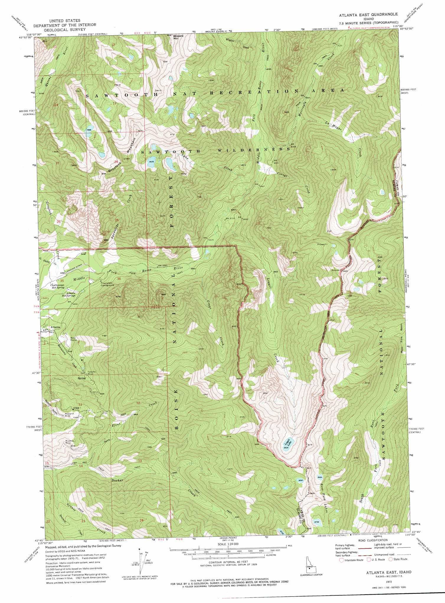
Atlanta East Topo Map Idaho
To zoom in, hover over the map of Atlanta East
USGS Topo Quad 43115g1 - 1:24,000 scale
| Topo Map Name: | Atlanta East |
| USGS Topo Quad ID: | 43115g1 |
| Print Size: | ca. 21 1/4" wide x 27" high |
| Southeast Coordinates: | 43.75° N latitude / 115° W longitude |
| Map Center Coordinates: | 43.8125° N latitude / 115.0625° W longitude |
| U.S. State: | ID |
| Filename: | o43115g1.jpg |
| Download Map JPG Image: | Atlanta East topo map 1:24,000 scale |
| Map Type: | Topographic |
| Topo Series: | 7.5´ |
| Map Scale: | 1:24,000 |
| Source of Map Images: | United States Geological Survey (USGS) |
| Alternate Map Versions: |
Atlanta East ID 1972, updated 1976 Download PDF Buy paper map Atlanta East ID 1972, updated 1976 Download PDF Buy paper map Atlanta East ID 2011 Download PDF Buy paper map Atlanta East ID 2013 Download PDF Buy paper map |
| FStopo: | US Forest Service topo Atlanta East is available: Download FStopo PDF Download FStopo TIF |
1:24,000 Topo Quads surrounding Atlanta East
Tyee Mountain |
Edaho Mountain |
Warbonnet Peak |
Mount Cramer |
Obsidian |
Swanholm Peak |
Nahneke Mountain |
Mount Everly |
Snowyside Peak |
Alturas Lake |
Phifer Creek |
Atlanta West |
Atlanta East |
Marshall Peak |
Frenchman Creek |
Rocky Bar |
Cayuse Point |
Ross Peak |
Newman Peak |
Paradise Peak |
Featherville |
Grouse Butte |
Jumbo Mountain |
Boardman Creek |
Sydney Butte |
> Back to 43115e1 at 1:100,000 scale
> Back to 43114a1 at 1:250,000 scale
> Back to U.S. Topo Maps home
Atlanta East topo map: Gazetteer
Atlanta East: Dams
Greene Tree Dam elevation 1642m 5387′Atlanta East: Lakes
Leggit Lake elevation 2600m 8530′Ross Fork Lakes elevation 2671m 8763′
Atlanta East: Mines
Minerva Mine elevation 1992m 6535′Monarch Mine elevation 2083m 6833′
Tolache Mine elevation 1829m 6000′
Atlanta East: Springs
Atlanta Hot Springs elevation 1662m 5452′Chattanooga Hot Spring elevation 1628m 5341′
Atlanta East: Streams
Corral Creek elevation 1792m 5879′Flint Creek elevation 1781m 5843′
Grays Creek elevation 1690m 5544′
Greylock Creek elevation 2546m 8353′
Grouse Creek elevation 1732m 5682′
Joe Daley Creek elevation 1643m 5390′
La Moyne Creek elevation 1980m 6496′
Leggit Creek elevation 1722m 5649′
Lynx Creek elevation 1762m 5780′
Mattingly Creek elevation 1793m 5882′
Misfire Creek elevation 1855m 6085′
Sawmill Creek elevation 1791m 5875′
Snowslide Creek elevation 1699m 5574′
Atlanta East: Summits
Blizzard Mountain elevation 2853m 9360′Grey Lock Peak elevation 2784m 9133′
Greylock Mountain elevation 2794m 9166′
Atlanta East digital topo map on disk
Buy this Atlanta East topo map showing relief, roads, GPS coordinates and other geographical features, as a high-resolution digital map file on DVD: