Boise North Topo Map Idaho
To zoom in, hover over the map of Boise North
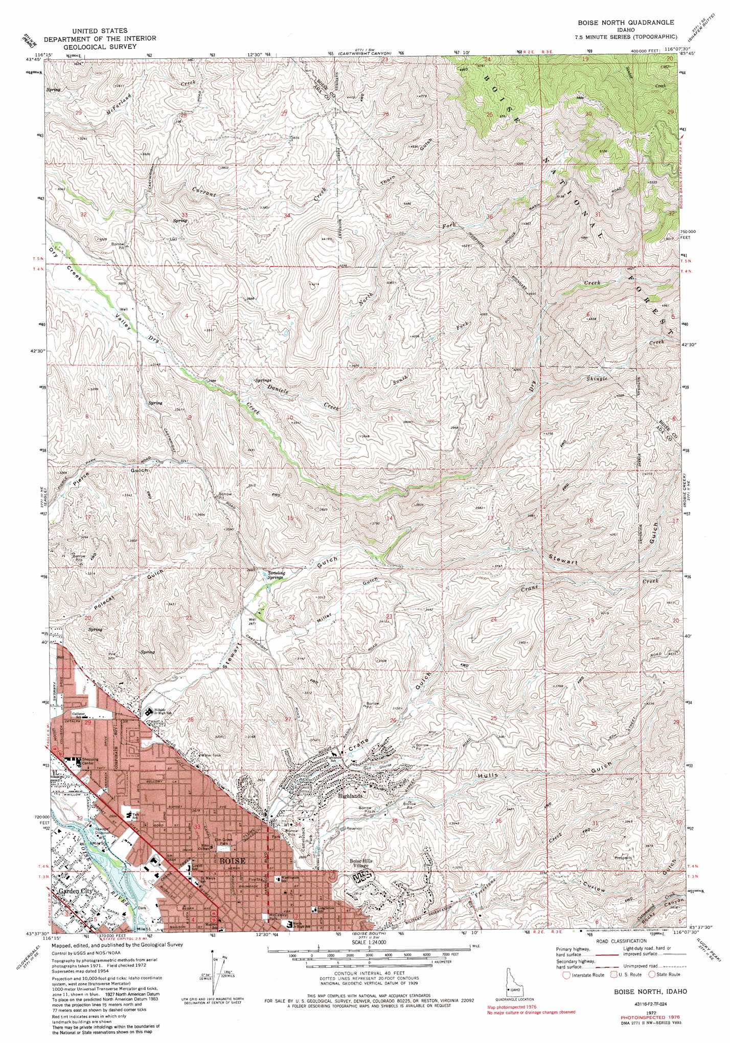
USGS Topo Quad 43116f2 - 1:24,000 scale
| Topo Map Name: | Boise North |
| USGS Topo Quad ID: | 43116f2 |
| Print Size: | ca. 21 1/4" wide x 27" high |
| Southeast Coordinates: | 43.625° N latitude / 116.125° W longitude |
| Map Center Coordinates: | 43.6875° N latitude / 116.1875° W longitude |
| U.S. State: | ID |
| Filename: | o43116f2.jpg |
| Download Map JPG Image: | Boise North topo map 1:24,000 scale |
| Map Type: | Topographic |
| Topo Series: | 7.5´ |
| Map Scale: | 1:24,000 |
| Source of Map Images: | United States Geological Survey (USGS) |
| Alternate Map Versions: |
Boise North ID 1954, updated 1957 Download PDF Buy paper map Boise North ID 1954, updated 1968 Download PDF Buy paper map Boise North ID 1972, updated 1975 Download PDF Buy paper map Boise North ID 1972, updated 1982 Download PDF Buy paper map Boise North ID 1972, updated 1991 Download PDF Buy paper map Boise North ID 2011 Download PDF Buy paper map Boise North ID 2013 Download PDF Buy paper map |
| FStopo: | US Forest Service topo Boise North is available: Download FStopo PDF Download FStopo TIF |
1:24,000 Topo Quads surrounding Boise North
Northeast Emmett |
Montour |
Horseshoe Bend |
Harris Creek Summit |
Placerville |
Southeast Emmett |
Pearl |
Cartwright Canyon |
Shafer Butte |
Warm Springs Point |
Star |
Eagle |
Boise North |
Robie Creek |
Dunnigan Creek |
Meridian |
Cloverdale |
Boise South |
Lucky Peak |
Arrowrock Dam |
Kuna |
Mora |
Owyhee |
Indian Creek Reservoir |
Mayfield |
> Back to 43116e1 at 1:100,000 scale
> Back to 43116a1 at 1:250,000 scale
> Back to U.S. Topo Maps home
Boise North topo map: Gazetteer
Boise North: Airports
Boise Cascade Heliport elevation 888m 2913′Boise North: Lakes
Boise Cascade Lake elevation 811m 2660′Boise North: Parks
Camelsback Park elevation 885m 2903′Elm Grove Park elevation 821m 2693′
McCauley Park elevation 822m 2696′
Sunset Park elevation 813m 2667′
Veterans Memorial State Park elevation 811m 2660′
Boise North: Populated Places
Boise Hills Village elevation 866m 2841′Collister elevation 809m 2654′
Highlands elevation 902m 2959′
Boise North: Springs
Terteling Springs elevation 914m 2998′Boise North: Streams
Crane Creek elevation 812m 2664′Daniels Creek elevation 950m 3116′
North Fork Daniels Creek elevation 1036m 3398′
Shingle Creek elevation 1177m 3861′
South Fork Daniels Creek elevation 1034m 3392′
Boise North: Trails
Hulls Gulch Nature Trail elevation 1262m 4140′Boise North: Valleys
Crane Gulch elevation 841m 2759′Hulls Gulch elevation 852m 2795′
Miller Gulch elevation 912m 2992′
Polecat Gulch elevation 845m 2772′
Stewart Gulch elevation 848m 2782′
Boise North digital topo map on disk
Buy this Boise North topo map showing relief, roads, GPS coordinates and other geographical features, as a high-resolution digital map file on DVD: