Caldwell Topo Map Idaho
To zoom in, hover over the map of Caldwell
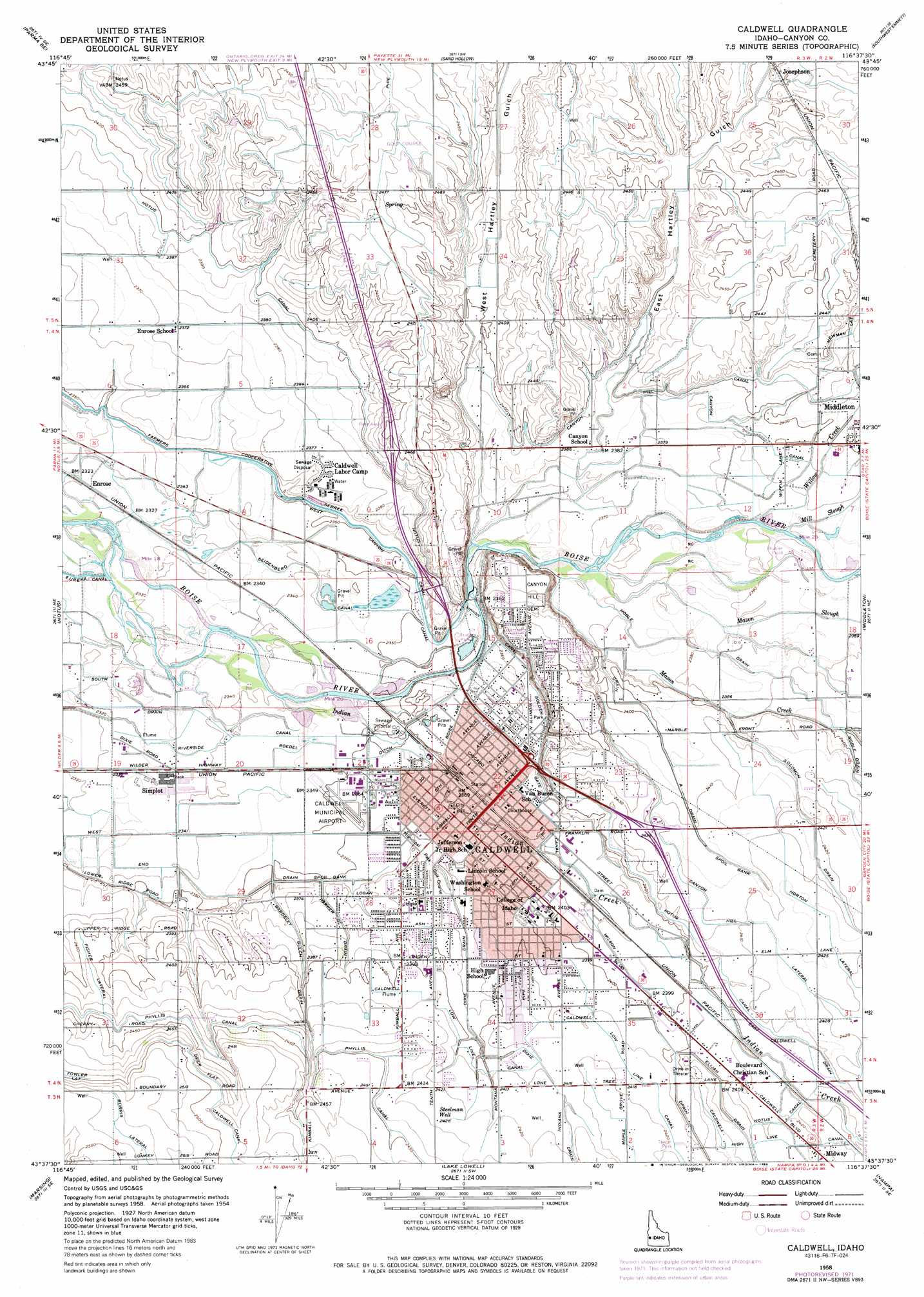
USGS Topo Quad 43116f6 - 1:24,000 scale
| Topo Map Name: | Caldwell |
| USGS Topo Quad ID: | 43116f6 |
| Print Size: | ca. 21 1/4" wide x 27" high |
| Southeast Coordinates: | 43.625° N latitude / 116.625° W longitude |
| Map Center Coordinates: | 43.6875° N latitude / 116.6875° W longitude |
| U.S. State: | ID |
| Filename: | o43116f6.jpg |
| Download Map JPG Image: | Caldwell topo map 1:24,000 scale |
| Map Type: | Topographic |
| Topo Series: | 7.5´ |
| Map Scale: | 1:24,000 |
| Source of Map Images: | United States Geological Survey (USGS) |
| Alternate Map Versions: |
Caldwell ID 1958, updated 1960 Download PDF Buy paper map Caldwell ID 1958, updated 1972 Download PDF Buy paper map Caldwell ID 1958, updated 1986 Download PDF Buy paper map Caldwell ID 2010 Download PDF Buy paper map Caldwell ID 2013 Download PDF Buy paper map |
1:24,000 Topo Quads surrounding Caldwell
Nyssa |
New Plymouth |
Letha |
Northwest Emmett |
Northeast Emmett |
Parma |
Parma Se |
Sand Hollow |
Southwest Emmett |
Southeast Emmett |
Wilder |
Notus |
Caldwell |
Middleton |
Star |
Homedale |
Marsing |
Lake Lowell |
Nampa |
Meridian |
Jump Creek Canyon |
Opalene Gulch |
Givens Hot Springs |
Melba |
Kuna |
> Back to 43116e1 at 1:100,000 scale
> Back to 43116a1 at 1:250,000 scale
> Back to U.S. Topo Maps home
Caldwell topo map: Gazetteer
Caldwell: Airports
Caldwell Industrial Airport elevation 739m 2424′Caldwell Municipal Airport elevation 717m 2352′
Hubler Field elevation 727m 2385′
Caldwell: Canals
A Drain elevation 732m 2401′Bardsly Gulch Drain elevation 725m 2378′
Caldwell Drain elevation 736m 2414′
Caldwell Low Line Canal elevation 737m 2417′
Canyon Hill Lateral elevation 740m 2427′
Dixie Drain elevation 731m 2398′
Fisher Lateral elevation 736m 2414′
Hill Canal elevation 734m 2408′
Horton Lateral elevation 740m 2427′
Parker Gulch Drain elevation 724m 2375′
Roedel Ditch elevation 717m 2352′
Seidenberd Canal elevation 713m 2339′
West Canyon Canal elevation 717m 2352′
Caldwell: Populated Places
Bugtown (historical) elevation 730m 2395′Caldwell elevation 724m 2375′
Enrose elevation 708m 2322′
Josephson elevation 749m 2457′
Midway elevation 742m 2434′
Simplot elevation 714m 2342′
Caldwell: Streams
Indian Creek elevation 716m 2349′Mason Creek elevation 721m 2365′
Mason Slough elevation 722m 2368′
Mill Slough elevation 726m 2381′
Willow Creek elevation 726m 2381′
Caldwell: Valleys
East Hartley Gulch elevation 722m 2368′West Hartley Gulch elevation 722m 2368′
Caldwell: Wells
Steelman Well elevation 740m 2427′Caldwell digital topo map on disk
Buy this Caldwell topo map showing relief, roads, GPS coordinates and other geographical features, as a high-resolution digital map file on DVD: