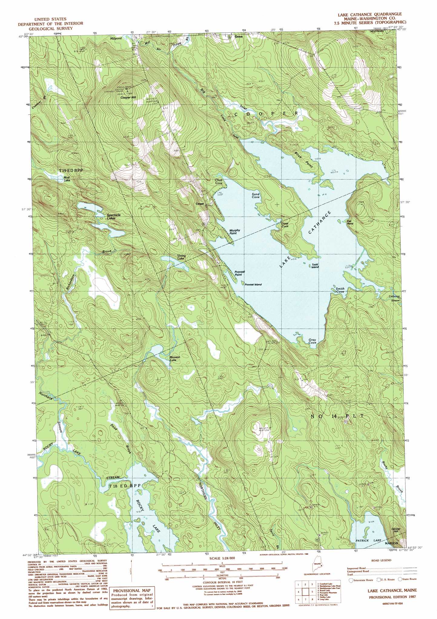
Lake Cathance Topo Map Maine
To zoom in, hover over the map of Lake Cathance
USGS Topo Quad 44067h4 - 1:24,000 scale
| Topo Map Name: | Lake Cathance |
| USGS Topo Quad ID: | 44067h4 |
| Print Size: | ca. 21 1/4" wide x 27" high |
| Southeast Coordinates: | 44.875° N latitude / 67.375° W longitude |
| Map Center Coordinates: | 44.9375° N latitude / 67.4375° W longitude |
| U.S. State: | ME |
| Filename: | o44067h4.jpg |
| Download Map JPG Image: | Lake Cathance topo map 1:24,000 scale |
| Map Type: | Topographic |
| Topo Series: | 7.5´ |
| Map Scale: | 1:24,000 |
| Source of Map Images: | United States Geological Survey (USGS) |
| Alternate Map Versions: |
Lake Cathance ME 1987, updated 1988 Download PDF Buy paper map Lake Cathance ME 2011 Download PDF Buy paper map Lake Cathance ME 2014 Download PDF Buy paper map |
1:24,000 Topo Quads surrounding Lake Cathance
Big Lake |
Princeton |
Woodland |
Calais |
Devils Head |
Clifford Lake |
Crawford Lake |
Meddybemp Lake West |
Meddybemp Lake East |
Red Beach |
Wesley |
Round Lake |
Lake Cathance |
Porcupine Mountain |
Pembroke |
Peaked Mountain Pond |
Bog Lake |
Hadley Lake |
Long Lake |
Whiting |
Columbia Falls |
Whitneyville |
Machias |
Machias Bay |
Cutler |
> Back to 44067e1 at 1:100,000 scale
> Back to 44066a1 at 1:250,000 scale
> Back to U.S. Topo Maps home
Lake Cathance topo map: Gazetteer
Lake Cathance: Bays
Chub Cove elevation 65m 213′Deep Cove elevation 65m 213′
Gray Cove elevation 65m 213′
Sand Cove elevation 66m 216′
Smith Cove elevation 65m 213′
Lake Cathance: Capes
Birch Point elevation 67m 219′Fox Point elevation 65m 213′
Murphy Point elevation 72m 236′
Provost Point elevation 67m 219′
Lake Cathance: Dams
Cathance Lake Dam elevation 66m 216′Lake Cathance: Flats
The Commons elevation 63m 206′Lake Cathance: Islands
Provost Island elevation 66m 216′Todd Island elevation 65m 213′
Lake Cathance: Lakes
Mud Lake elevation 84m 275′Munson Lake elevation 47m 154′
Patrick Lake elevation 39m 127′
Spectacle Lakes elevation 68m 223′
Vining Lake elevation 84m 275′
Lake Cathance: Populated Places
Cooper elevation 82m 269′Lake Cathance: Reservoirs
Lake Cathance elevation 66m 216′Lake Cathance: Streams
Big Inlet elevation 65m 213′Dead Brook elevation 18m 59′
Howe Brook elevation 90m 295′
Little Inlet elevation 65m 213′
Mill Stream elevation 90m 295′
Northern Stream elevation 19m 62′
Richardson Brook elevation 21m 68′
Lake Cathance: Summits
Conner Hill elevation 80m 262′Cooper Hill elevation 217m 711′
Lake Cathance digital topo map on disk
Buy this Lake Cathance topo map showing relief, roads, GPS coordinates and other geographical features, as a high-resolution digital map file on DVD:
Maine, New Hampshire, Rhode Island & Eastern Massachusetts
Buy digital topo maps: Maine, New Hampshire, Rhode Island & Eastern Massachusetts