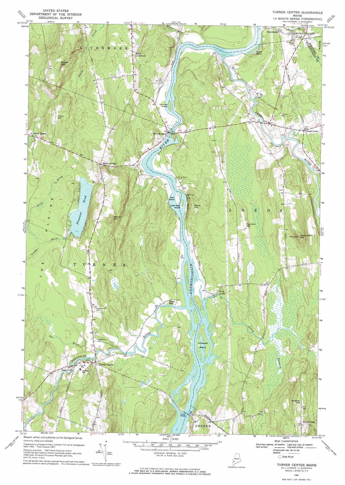
Turner Center Topo Map Maine
To zoom in, hover over the map of Turner Center
USGS Topo Quad 44070c2 - 1:24,000 scale
| Topo Map Name: | Turner Center |
| USGS Topo Quad ID: | 44070c2 |
| Print Size: | ca. 21 1/4" wide x 27" high |
| Southeast Coordinates: | 44.25° N latitude / 70.125° W longitude |
| Map Center Coordinates: | 44.3125° N latitude / 70.1875° W longitude |
| U.S. State: | ME |
| Filename: | o44070c2.jpg |
| Download Map JPG Image: | Turner Center topo map 1:24,000 scale |
| Map Type: | Topographic |
| Topo Series: | 7.5´ |
| Map Scale: | 1:24,000 |
| Source of Map Images: | United States Geological Survey (USGS) |
| Alternate Map Versions: |
Turner Center ME 1967, updated 1969 Download PDF Buy paper map Turner Center ME 1967, updated 1969 Download PDF Buy paper map Turner Center ME 2011 Download PDF Buy paper map Turner Center ME 2014 Download PDF Buy paper map |
1:24,000 Topo Quads surrounding Turner Center
Dixfield |
East Dixfield |
Wilton |
Farmington Falls |
Belgrade Lakes |
Worthley Pond |
Canton |
Livermore Falls |
Fayette |
Readfield |
West Sumner |
Buckfield |
Turner Center |
Wayne |
Winthrop |
Oxford |
Lake Auburn West |
Lake Auburn East |
Monmouth |
Purgatory |
Mechanic Falls |
Minot |
Lewiston |
Lisbon Falls North |
Bowdoinham |
> Back to 44070a1 at 1:100,000 scale
> Back to 44070a1 at 1:250,000 scale
> Back to U.S. Topo Maps home
Turner Center topo map: Gazetteer
Turner Center: Bridges
Turner Bridge elevation 80m 262′Turner Center: Dams
Dead River Dam elevation 81m 265′Pleasant Pond Dam elevation 115m 377′
Turner Center: Islands
Griswold Island elevation 80m 262′Little Ram Island elevation 81m 265′
Lovewell Island elevation 81m 265′
Ram Island elevation 87m 285′
Turtle Island elevation 82m 269′
Turner Center: Plains
The Plains elevation 113m 370′Turner Center: Populated Places
Howes Corner elevation 125m 410′North Leeds elevation 86m 282′
South Leeds elevation 171m 561′
South Livermore elevation 153m 501′
Stricklands elevation 94m 308′
Turner Center elevation 91m 298′
West Leeds elevation 86m 282′
Turner Center: Reservoirs
Dead River Reservoir elevation 81m 265′Pleasant Pond elevation 115m 377′
Turner Center: Streams
Allen Stream elevation 80m 262′Dead River elevation 82m 269′
House Brook elevation 107m 351′
Keith Brook elevation 82m 269′
Nezinscot River elevation 81m 265′
Red Brook elevation 81m 265′
Turner Center: Summits
Butter Hill elevation 235m 770′Fairview Hill elevation 123m 403′
Merrill Hill elevation 215m 705′
Monument Hill elevation 200m 656′
Quaker Hill elevation 193m 633′
Sand Hill elevation 126m 413′
Torry Hill elevation 177m 580′
Turner Center: Trails
Monument Hill Trail elevation 175m 574′Turner Center digital topo map on disk
Buy this Turner Center topo map showing relief, roads, GPS coordinates and other geographical features, as a high-resolution digital map file on DVD:
Maine, New Hampshire, Rhode Island & Eastern Massachusetts
Buy digital topo maps: Maine, New Hampshire, Rhode Island & Eastern Massachusetts