Mount Mansfield Topo Map Vermont
To zoom in, hover over the map of Mount Mansfield
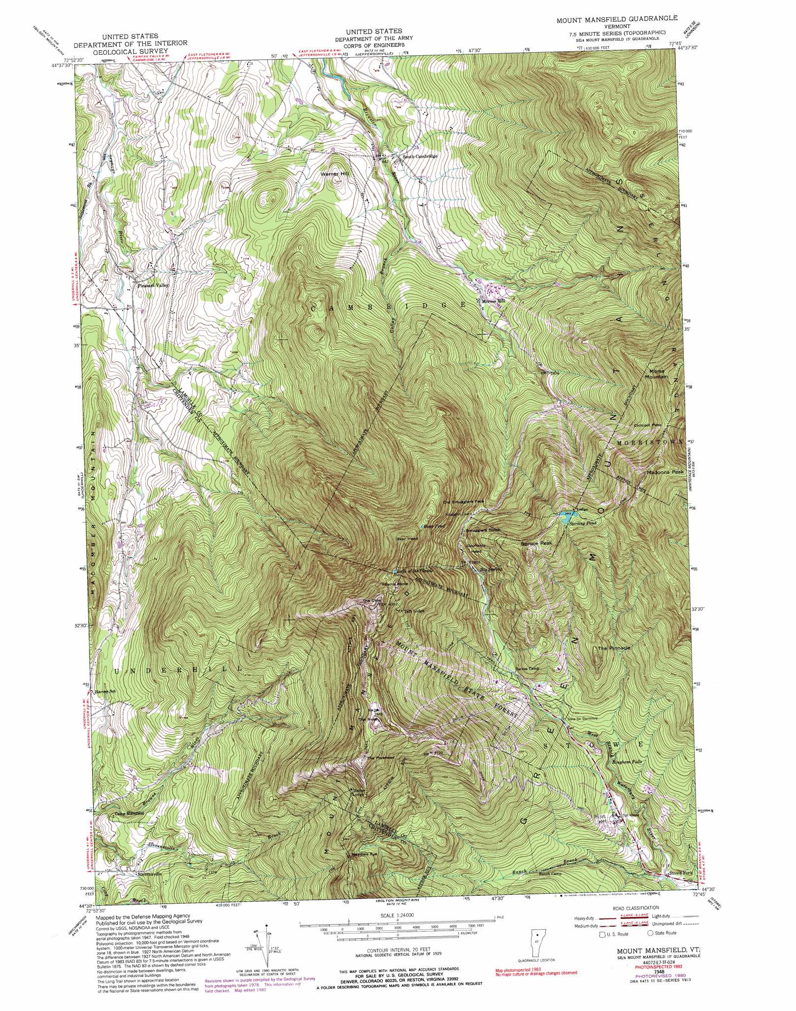
USGS Topo Quad 44072e7 - 1:24,000 scale
| Topo Map Name: | Mount Mansfield |
| USGS Topo Quad ID: | 44072e7 |
| Print Size: | ca. 21 1/4" wide x 27" high |
| Southeast Coordinates: | 44.5° N latitude / 72.75° W longitude |
| Map Center Coordinates: | 44.5625° N latitude / 72.8125° W longitude |
| U.S. State: | VT |
| Filename: | o44072e7.jpg |
| Download Map JPG Image: | Mount Mansfield topo map 1:24,000 scale |
| Map Type: | Topographic |
| Topo Series: | 7.5´ |
| Map Scale: | 1:24,000 |
| Source of Map Images: | United States Geological Survey (USGS) |
| Alternate Map Versions: |
Mount Mansfield VT 1948, updated 1953 Download PDF Buy paper map Mount Mansfield VT 1948, updated 1966 Download PDF Buy paper map Mount Mansfield VT 1948, updated 1972 Download PDF Buy paper map Mount Mansfield VT 1948, updated 1981 Download PDF Buy paper map Mount Mansfield VT 1948, updated 1992 Download PDF Buy paper map Mount Mansfield VT 1948, updated 1992 Download PDF Buy paper map Mount Mansfield VT 1997, updated 2000 Download PDF Buy paper map Mount Mansfield VT 2012 Download PDF Buy paper map Mount Mansfield VT 2015 Download PDF Buy paper map |
1:24,000 Topo Quads surrounding Mount Mansfield
Saint Albans |
Fairfield |
Bakersfield |
Cold Hollow Mountains |
Hazens Notch |
Milton |
Gilson Mountain |
Jeffersonville |
Johnson |
Eden |
Essex Center |
Underhill |
Mount Mansfield |
Whiteface Mountain |
Morrisville |
Essex Junction |
Richmond |
Bolton Mountain |
Stowe |
Mount Worcester |
Hinesburg |
Huntington |
Waterbury |
Middlesex |
Montpelier |
> Back to 44072e1 at 1:100,000 scale
> Back to 44072a1 at 1:250,000 scale
> Back to U.S. Topo Maps home
Mount Mansfield topo map: Gazetteer
Mount Mansfield: Falls
Bingham Falls elevation 571m 1873′Bingham Falls elevation 378m 1240′
Mount Mansfield: Forests
Morristown Municipal Forest elevation 893m 2929′Mount Mansfield State Forest elevation 608m 1994′
Mount Mansfield: Gaps
Chilcoot Pass elevation 900m 2952′Needles Eye elevation 812m 2664′
Smugglers Notch elevation 661m 2168′
Mount Mansfield: Lakes
Bear Pond elevation 1073m 3520′Lake of the Clouds elevation 1198m 3930′
Sterling Pond elevation 918m 3011′
Mount Mansfield: Pillars
Elephants Head elevation 697m 2286′Old Smugglers Face elevation 841m 2759′
Mount Mansfield: Populated Places
Morses Mill elevation 323m 1059′Pleasant Valley elevation 188m 616′
South Cambridge elevation 260m 853′
Stevensville elevation 348m 1141′
Stowe Fork elevation 291m 954′
Mount Mansfield: Ranges
Green Mountains elevation 1337m 4386′Mount Mansfield: Springs
Big Spring elevation 541m 1774′Mount Mansfield: Streams
Gallup Branch elevation 274m 898′Ranch Brook elevation 291m 954′
Settlement Brook elevation 150m 492′
Mount Mansfield: Summits
Adams Apple elevation 1256m 4120′Bear Head elevation 1192m 3910′
Macomber Mountain elevation 465m 1525′
Madonna Peak elevation 1109m 3638′
Morse Mountain elevation 1029m 3375′
Mount Mansfield elevation 1337m 4386′
Spruce Peak elevation 1014m 3326′
The Chin elevation 1337m 4386′
The Forehead elevation 1185m 3887′
The Nose elevation 1229m 4032′
The Pinnacle elevation 667m 2188′
Warner Hill elevation 369m 1210′
Mount Mansfield: Trails
Haselton Trail elevation 635m 2083′Nose Dive Trail elevation 647m 2122′
The Long Trail elevation 654m 2145′
Mount Mansfield digital topo map on disk
Buy this Mount Mansfield topo map showing relief, roads, GPS coordinates and other geographical features, as a high-resolution digital map file on DVD:
New York, Vermont, Connecticut & Western Massachusetts
Buy digital topo maps: New York, Vermont, Connecticut & Western Massachusetts