Essex Center Topo Map Vermont
To zoom in, hover over the map of Essex Center
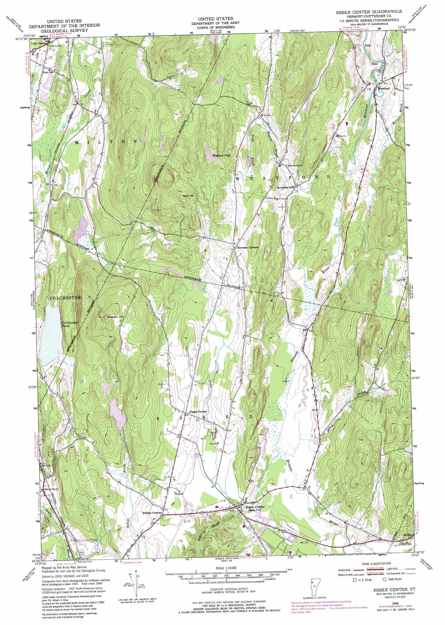
USGS Topo Quad 44073e1 - 1:24,000 scale
| Topo Map Name: | Essex Center |
| USGS Topo Quad ID: | 44073e1 |
| Print Size: | ca. 21 1/4" wide x 27" high |
| Southeast Coordinates: | 44.5° N latitude / 73° W longitude |
| Map Center Coordinates: | 44.5625° N latitude / 73.0625° W longitude |
| U.S. State: | VT |
| Filename: | o44073e1.jpg |
| Download Map JPG Image: | Essex Center topo map 1:24,000 scale |
| Map Type: | Topographic |
| Topo Series: | 7.5´ |
| Map Scale: | 1:24,000 |
| Source of Map Images: | United States Geological Survey (USGS) |
| Alternate Map Versions: |
Essex Center VT 1948, updated 1953 Download PDF Buy paper map Essex Center VT 1948, updated 1967 Download PDF Buy paper map Essex Center VT 1948, updated 1973 Download PDF Buy paper map Essex Center VT 1948, updated 1987 Download PDF Buy paper map Essex Center VT 2012 Download PDF Buy paper map Essex Center VT 2015 Download PDF Buy paper map |
1:24,000 Topo Quads surrounding Essex Center
North Hero |
Saint Albans Bay |
Saint Albans |
Fairfield |
Bakersfield |
South Hero |
Georgia Plains |
Milton |
Gilson Mountain |
Jeffersonville |
Colchester Point |
Colchester |
Essex Center |
Underhill |
Mount Mansfield |
Juniper Island |
Burlington |
Essex Junction |
Richmond |
Bolton Mountain |
Charlotte |
Mount Philo |
Hinesburg |
Huntington |
Waterbury |
> Back to 44073e1 at 1:100,000 scale
> Back to 44072a1 at 1:250,000 scale
> Back to U.S. Topo Maps home
Essex Center topo map: Gazetteer
Essex Center: Dams
Colchester Pond Dam elevation 117m 383′Indian Brook Dam elevation 161m 528′
Essex Center: Forests
Essex Junction Village Forest elevation 155m 508′Essex Junction Village Municipal Forest elevation 155m 508′
Essex Center: Lakes
Colchester Pond elevation 113m 370′Westford Pond elevation 241m 790′
Essex Center: Populated Places
Bowman Corners elevation 224m 734′Brookside elevation 177m 580′
Butlers Corners elevation 160m 524′
Cozy Corner elevation 105m 344′
Essex Center elevation 147m 482′
Pages Corner elevation 180m 590′
Westford elevation 136m 446′
Essex Center: Post Offices
Butlers Corner Post Office elevation 151m 495′Essex Center: Reservoirs
Colchester Pond elevation 117m 383′Indian Brook Reservoir elevation 161m 528′
Indian Brook Reservoir elevation 156m 511′
Essex Center: Streams
Abbey Brook elevation 144m 472′Morgan Brook elevation 133m 436′
Pond Brook elevation 196m 643′
Rogers Brook elevation 134m 439′
Essex Center: Summits
Bald Hill elevation 318m 1043′Brigham Hill elevation 308m 1010′
Essex Center digital topo map on disk
Buy this Essex Center topo map showing relief, roads, GPS coordinates and other geographical features, as a high-resolution digital map file on DVD:
New York, Vermont, Connecticut & Western Massachusetts
Buy digital topo maps: New York, Vermont, Connecticut & Western Massachusetts