Childwold Topo Map New York
To zoom in, hover over the map of Childwold
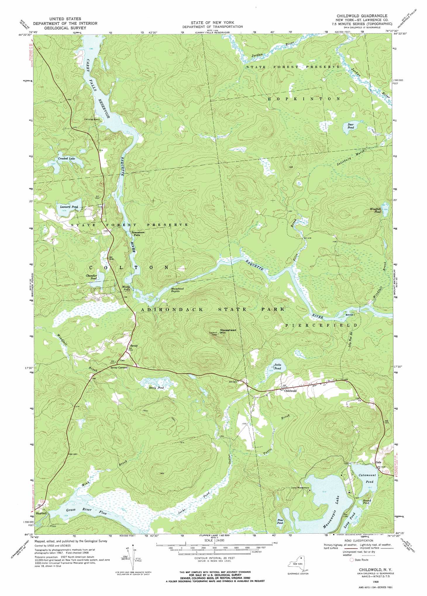
USGS Topo Quad 44074c6 - 1:24,000 scale
| Topo Map Name: | Childwold |
| USGS Topo Quad ID: | 44074c6 |
| Print Size: | ca. 21 1/4" wide x 27" high |
| Southeast Coordinates: | 44.25° N latitude / 74.625° W longitude |
| Map Center Coordinates: | 44.3125° N latitude / 74.6875° W longitude |
| U.S. State: | NY |
| Filename: | o44074c6.jpg |
| Download Map JPG Image: | Childwold topo map 1:24,000 scale |
| Map Type: | Topographic |
| Topo Series: | 7.5´ |
| Map Scale: | 1:24,000 |
| Source of Map Images: | United States Geological Survey (USGS) |
| Alternate Map Versions: |
Childwold NY 1968, updated 1971 Download PDF Buy paper map Childwold NY 2010 Download PDF Buy paper map Childwold NY 2013 Download PDF Buy paper map Childwold NY 2016 Download PDF Buy paper map |
1:24,000 Topo Quads surrounding Childwold
Colton |
Rainbow Falls |
Sylvan Falls |
Lake Ozonia |
Meno |
Albert Marsh |
Stark |
Carry Falls Reservoir |
Augerhole Falls |
|
Tooley Pond |
Brother Ponds |
Childwold |
Mount Matumbla |
|
Newton Falls |
Cranberry Lake |
Pierce Field |
||
Five Ponds |
Wolf Mountain |
Slim Pond |
> Back to 44074a1 at 1:100,000 scale
> Back to 44074a1 at 1:250,000 scale
> Back to U.S. Topo Maps home
Childwold topo map: Gazetteer
Childwold: Falls
Jamestown Falls elevation 422m 1384′Moody Falls elevation 427m 1400′
Childwold: Islands
Smith Island elevation 446m 1463′Childwold: Lakes
Catamount Pond elevation 462m 1515′Chandler Pond elevation 436m 1430′
Crooked Lake elevation 447m 1466′
Deer Pond elevation 460m 1509′
Jocks Pond elevation 468m 1535′
Leonard Pond elevation 449m 1473′
Long Pond elevation 465m 1525′
Massawepie Lake elevation 461m 1512′
Pine Pond elevation 461m 1512′
Round Pond elevation 467m 1532′
Sevey Pond elevation 466m 1528′
Windfall Pond elevation 474m 1555′
Childwold: Populated Places
Childwold elevation 496m 1627′Childwold Park elevation 469m 1538′
Gale elevation 466m 1528′
Sevey elevation 467m 1532′
Shurtleff elevation 458m 1502′
Childwold: Rapids
Halls Rapids (historical) elevation 422m 1384′Long Rapids (historical) elevation 422m 1384′
Moosehead Rapids elevation 439m 1440′
Childwold: Reservoirs
Grass River Flow elevation 458m 1502′Childwold: Streams
Bear Brook elevation 445m 1459′Ellis Brook elevation 445m 1459′
Jocks Pond Outlet elevation 459m 1505′
Lily Pad Brook elevation 445m 1459′
Mink Brook elevation 459m 1505′
Tuttle Brook elevation 463m 1519′
Windfall Brook elevation 447m 1466′
Childwold: Summits
Moosehead Mountain elevation 631m 2070′Childwold: Swamps
Salisbury Marsh elevation 461m 1512′Childwold digital topo map on disk
Buy this Childwold topo map showing relief, roads, GPS coordinates and other geographical features, as a high-resolution digital map file on DVD:
New York, Vermont, Connecticut & Western Massachusetts
Buy digital topo maps: New York, Vermont, Connecticut & Western Massachusetts