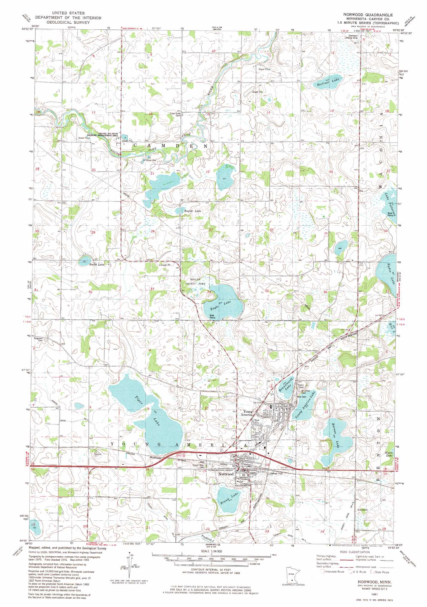
Norwood Topo Map Minnesota
To zoom in, hover over the map of Norwood
USGS Topo Quad 44093g8 - 1:24,000 scale
| Topo Map Name: | Norwood |
| USGS Topo Quad ID: | 44093g8 |
| Print Size: | ca. 21 1/4" wide x 27" high |
| Southeast Coordinates: | 44.75° N latitude / 93.875° W longitude |
| Map Center Coordinates: | 44.8125° N latitude / 93.9375° W longitude |
| U.S. State: | MN |
| Filename: | o44093g8.jpg |
| Download Map JPG Image: | Norwood topo map 1:24,000 scale |
| Map Type: | Topographic |
| Topo Series: | 7.5´ |
| Map Scale: | 1:24,000 |
| Source of Map Images: | United States Geological Survey (USGS) |
| Alternate Map Versions: |
Norwood MN 1981, updated 1982 Download PDF Buy paper map Norwood MN 2010 Download PDF Buy paper map Norwood MN 2013 Download PDF Buy paper map Norwood MN 2016 Download PDF Buy paper map |
1:24,000 Topo Quads surrounding Norwood
Cokato |
Howard Lake |
Waverly |
Delano |
Rockford |
Silver Lake |
Winsted |
Mayer |
Watertown |
Mound |
Glenco |
Plato |
Norwood |
Waconia |
Victoria |
New Auburn |
Green Isle |
Hamburg |
Belle Plaine North |
Jordan West |
Gaylord |
Arlington |
Henderson |
Belle Plaine South |
Union Hill |
> Back to 44093e1 at 1:100,000 scale
> Back to 44092a1 at 1:250,000 scale
> Back to U.S. Topo Maps home
Norwood topo map: Gazetteer
Norwood: Airports
Ziermann Landing Strip elevation 300m 984′Norwood: Canals
County Ditch Number Five elevation 296m 971′Judicial Ditch Number Five elevation 298m 977′
Norwood: Channels
Church of the Ascension elevation 305m 1000′Norwood: Lakes
Barnes Lake elevation 294m 964′Baylor Lake elevation 290m 951′
Berliner Lake elevation 291m 954′
Brand Lake elevation 297m 974′
Braunworth Lake elevation 297m 974′
Eagle Lake elevation 294m 964′
Smith Lake elevation 294m 964′
Tiger Lake elevation 294m 964′
Young America Lake elevation 297m 974′
Norwood: Parks
Baylor County Park elevation 294m 964′Friendship Park elevation 301m 987′
Gravel Pit State Wildlife Management Area elevation 293m 961′
Wilkommen Park elevation 313m 1026′
Norwood: Populated Places
Faxon Court elevation 299m 980′Norwood elevation 304m 997′
Norwood Young America elevation 302m 990′
Young America elevation 314m 1030′
Norwood: Post Offices
Norwood Post Office elevation 299m 980′Young America Post Office elevation 311m 1020′
Norwood: Streams
Buffalo Creek elevation 287m 941′Norwood digital topo map on disk
Buy this Norwood topo map showing relief, roads, GPS coordinates and other geographical features, as a high-resolution digital map file on DVD: