Courthouse Rock Topo Map Oregon
To zoom in, hover over the map of Courthouse Rock
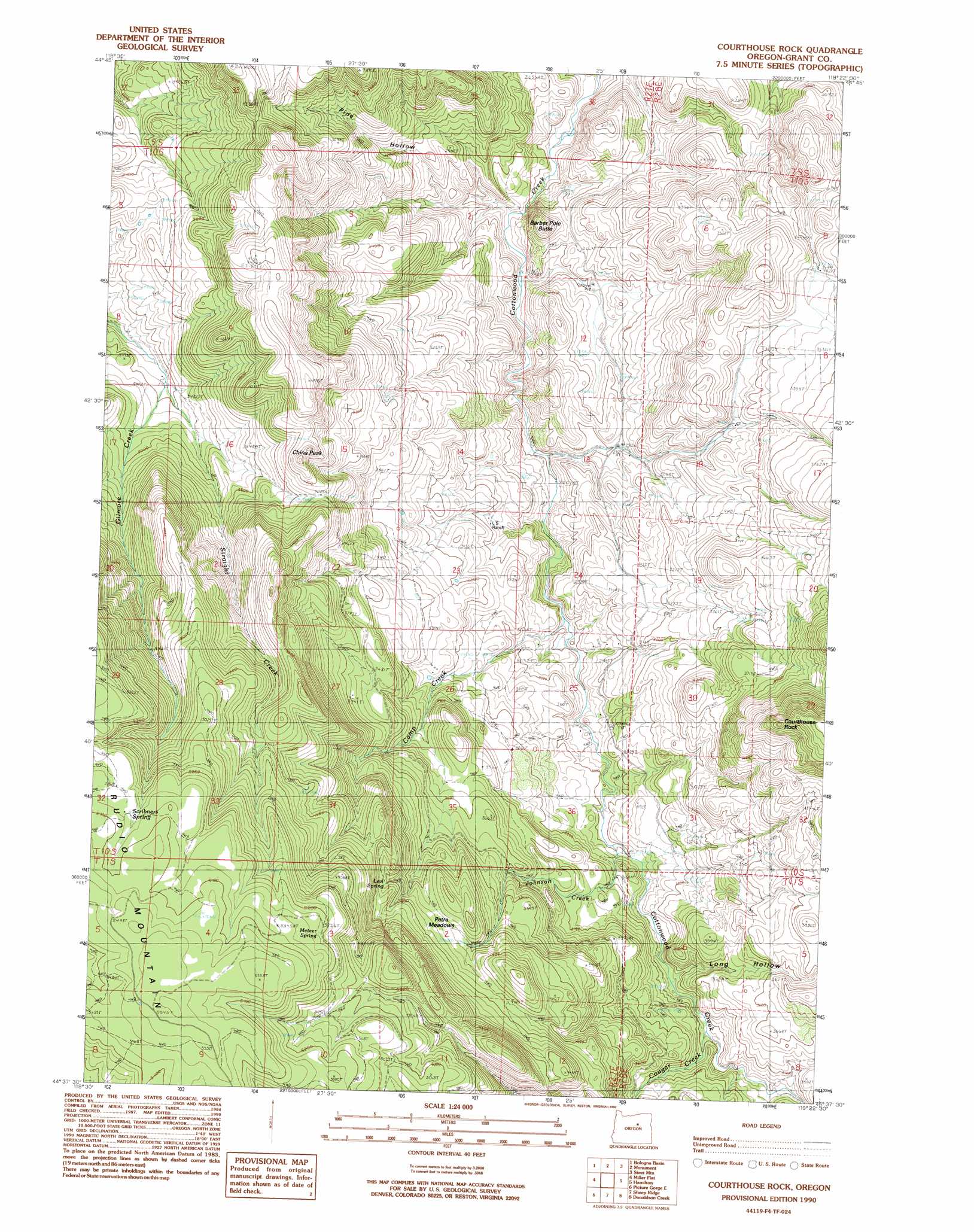
USGS Topo Quad 44119f4 - 1:24,000 scale
| Topo Map Name: | Courthouse Rock |
| USGS Topo Quad ID: | 44119f4 |
| Print Size: | ca. 21 1/4" wide x 27" high |
| Southeast Coordinates: | 44.625° N latitude / 119.375° W longitude |
| Map Center Coordinates: | 44.6875° N latitude / 119.4375° W longitude |
| U.S. State: | OR |
| Filename: | o44119f4.jpg |
| Download Map JPG Image: | Courthouse Rock topo map 1:24,000 scale |
| Map Type: | Topographic |
| Topo Series: | 7.5´ |
| Map Scale: | 1:24,000 |
| Source of Map Images: | United States Geological Survey (USGS) |
| Alternate Map Versions: |
Courthouse Rock OR 1990, updated 1990 Download PDF Buy paper map Courthouse Rock OR 2011 Download PDF Buy paper map Courthouse Rock OR 2014 Download PDF Buy paper map |
1:24,000 Topo Quads surrounding Courthouse Rock
Whitetail Butte |
Turner Mountain |
Johnny Cake Mountain |
Slickear Mountain |
Ritter |
Kimberly |
Bologna Basin |
Monument |
Steet Mountain |
Bullock Gulch |
Mount Misery |
Miller Flat |
Courthouse Rock |
Hamilton |
Fox |
Picture Gorge West |
Picture Gorge East |
Sheep Ridge |
Donaldson Creek |
Belshaw Meadows |
Day Basin |
Dayville |
Aldrich Mountain North |
Shop Gulch |
Wolfinger Butte |
> Back to 44119e1 at 1:100,000 scale
> Back to 44118a1 at 1:250,000 scale
> Back to U.S. Topo Maps home
Courthouse Rock topo map: Gazetteer
Courthouse Rock: Flats
Petre Meadows elevation 1239m 4064′Courthouse Rock: Post Offices
Cottonwood Post Office (historical) elevation 778m 2552′Courthouse Rock: Springs
Davis Spring elevation 1000m 3280′Levi Spring elevation 1292m 4238′
Meteer Spring elevation 1583m 5193′
Scribners Spring elevation 1623m 5324′
Courthouse Rock: Streams
Camp Creek elevation 841m 2759′Cougar Creek elevation 963m 3159′
Johnson Creek elevation 916m 3005′
Kingsley Creek elevation 851m 2791′
Straight Creek elevation 1026m 3366′
Courthouse Rock: Summits
Barber Pole Butte elevation 894m 2933′China Peak elevation 1356m 4448′
Courthouse Rock elevation 1396m 4580′
Courthouse Rock: Valleys
Davis Gulch elevation 788m 2585′Long Hollow elevation 955m 3133′
Pine Hollow elevation 754m 2473′
Courthouse Rock digital topo map on disk
Buy this Courthouse Rock topo map showing relief, roads, GPS coordinates and other geographical features, as a high-resolution digital map file on DVD: