Opal Mountain Topo Map Oregon
To zoom in, hover over the map of Opal Mountain
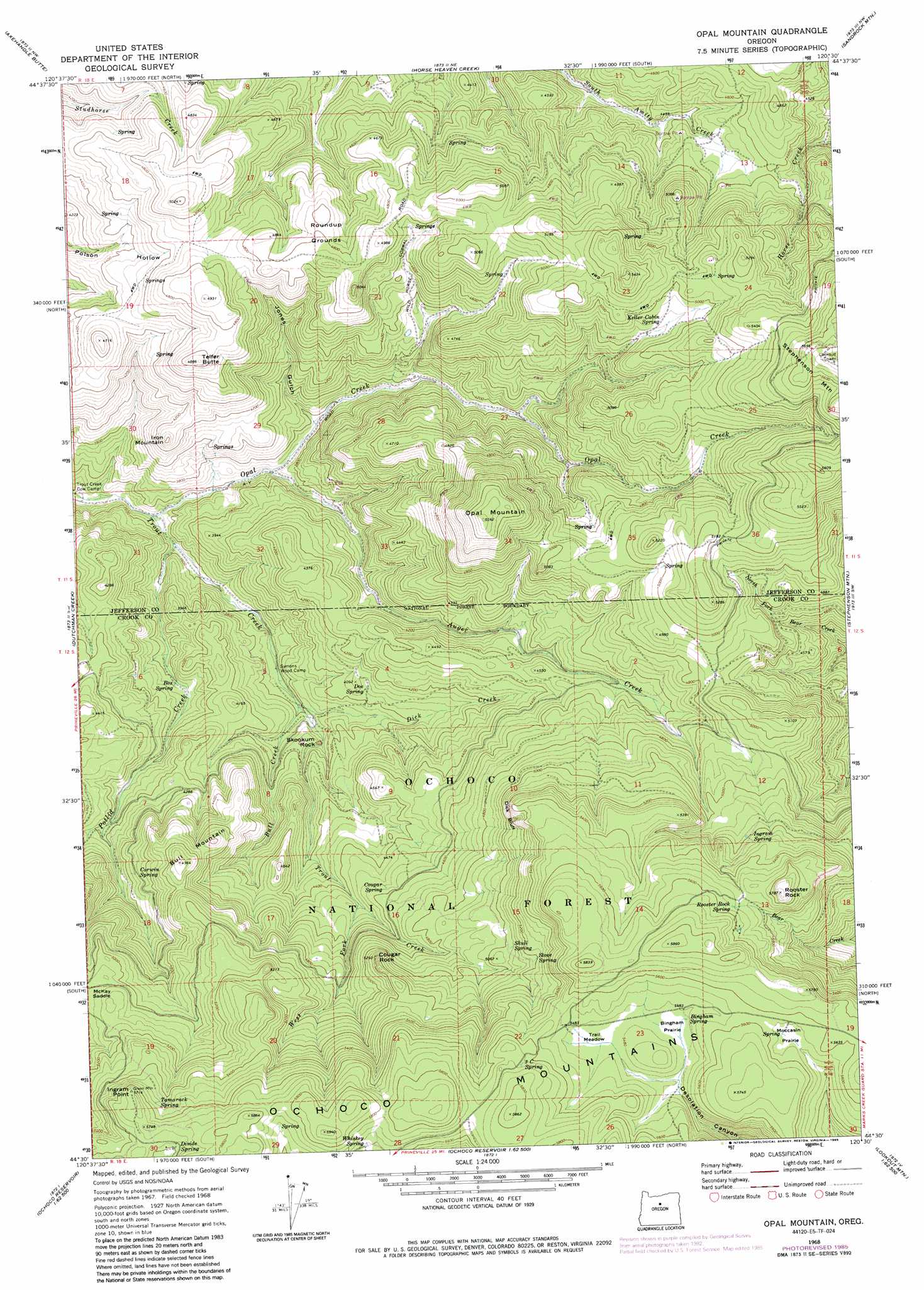
USGS Topo Quad 44120e5 - 1:24,000 scale
| Topo Map Name: | Opal Mountain |
| USGS Topo Quad ID: | 44120e5 |
| Print Size: | ca. 21 1/4" wide x 27" high |
| Southeast Coordinates: | 44.5° N latitude / 120.5° W longitude |
| Map Center Coordinates: | 44.5625° N latitude / 120.5625° W longitude |
| U.S. State: | OR |
| Filename: | o44120e5.jpg |
| Download Map JPG Image: | Opal Mountain topo map 1:24,000 scale |
| Map Type: | Topographic |
| Topo Series: | 7.5´ |
| Map Scale: | 1:24,000 |
| Source of Map Images: | United States Geological Survey (USGS) |
| Alternate Map Versions: |
Opal Mountain OR 1968, updated 1973 Download PDF Buy paper map Opal Mountain OR 1968, updated 1985 Download PDF Buy paper map Opal Mountain OR 1992, updated 1998 Download PDF Buy paper map Opal Mountain OR 2011 Download PDF Buy paper map Opal Mountain OR 2014 Download PDF Buy paper map |
| FStopo: | US Forest Service topo Opal Mountain is available: Download FStopo PDF Download FStopo TIF |
1:24,000 Topo Quads surrounding Opal Mountain
Degner Canyon |
Donnybrook |
Arrastra Butte |
Muddy Ranch |
Jennies Peak |
Ashwood |
Axehandle Butte |
Horse Heaven Creek |
Sandrock Mountain |
Painted Hills |
Foley Butte |
Dutchman Creek |
Opal Mountain |
Stephenson Mountain |
Lawson Mountain |
Hensley Butte |
Salt Butte |
Wildcat Mountain |
Whistler Point |
Ochoco Butte |
Prineville |
Ochoco Reservoir |
Cadle Butte |
Gerow Butte |
Lookout Mountain |
> Back to 44120e1 at 1:100,000 scale
> Back to 44120a1 at 1:250,000 scale
> Back to U.S. Topo Maps home
Opal Mountain topo map: Gazetteer
Opal Mountain: Cliffs
Dick Bluff elevation 1590m 5216′Opal Mountain: Flats
Bingham Prairie elevation 1666m 5465′Moccasin Prairie elevation 1692m 5551′
Trail Meadow elevation 1667m 5469′
Opal Mountain: Pillars
Cougar Rock elevation 1569m 5147′Skookum Rock elevation 1233m 4045′
Opal Mountain: Springs
Bingham Spring elevation 1670m 5479′Box Spring elevation 1166m 3825′
Carwin Spring elevation 1365m 4478′
Cougar Spring elevation 1384m 4540′
Divide Spring elevation 1711m 5613′
Doe Spring elevation 1241m 4071′
Ingram Spring elevation 1592m 5223′
Keller Cabin Spring elevation 1493m 4898′
Lodgepole Spring elevation 1592m 5223′
Rooster Rock Spring elevation 1690m 5544′
Skull Spring elevation 1534m 5032′
Stove Spring elevation 1582m 5190′
Tamarack Spring elevation 1677m 5501′
Three C Spring elevation 1729m 5672′
Whiskey Spring elevation 1719m 5639′
Opal Mountain: Streams
Auger Creek elevation 1111m 3645′Bull Creek elevation 1157m 3795′
Dick Creek elevation 1156m 3792′
Opal Creek elevation 1066m 3497′
Potlid Creek elevation 1078m 3536′
West Fork Trout Creek elevation 1354m 4442′
Opal Mountain: Summits
Bull Mountain elevation 1513m 4963′Ingram Point elevation 1736m 5695′
Iron Mountain elevation 1342m 4402′
Opal Mountain elevation 1671m 5482′
Rooster Rock elevation 1761m 5777′
Telfer Butte elevation 1485m 4872′
Opal Mountain: Valleys
Jones Gulch elevation 1166m 3825′Opal Mountain digital topo map on disk
Buy this Opal Mountain topo map showing relief, roads, GPS coordinates and other geographical features, as a high-resolution digital map file on DVD: