Axehandle Butte Topo Map Oregon
To zoom in, hover over the map of Axehandle Butte
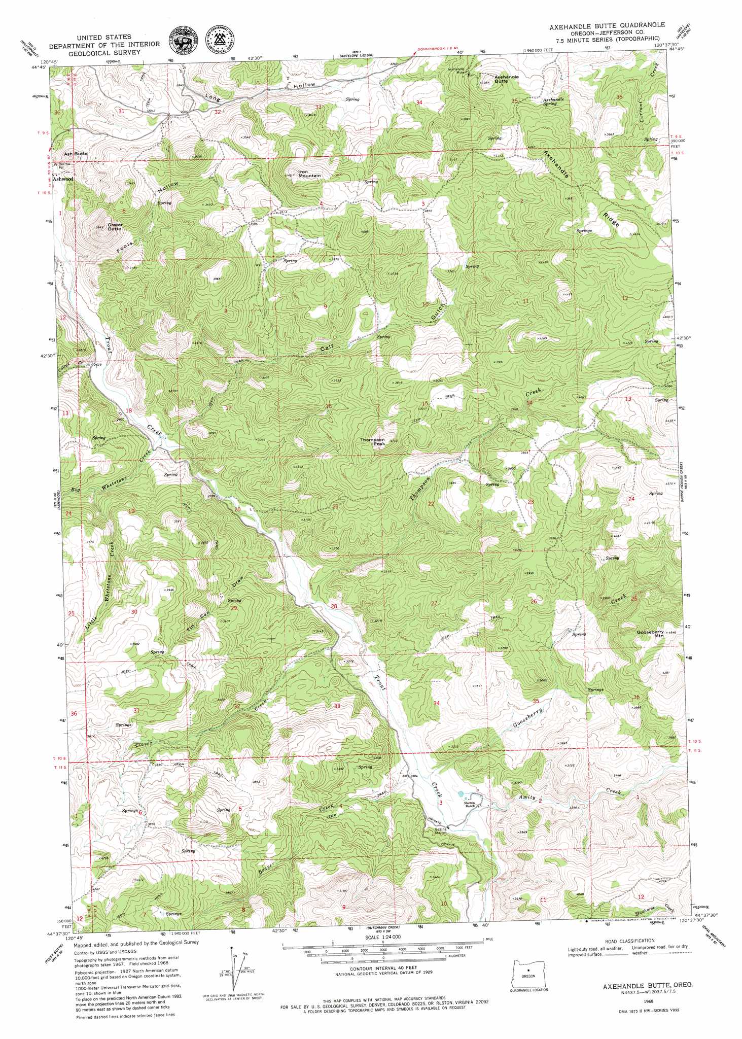
USGS Topo Quad 44120f6 - 1:24,000 scale
| Topo Map Name: | Axehandle Butte |
| USGS Topo Quad ID: | 44120f6 |
| Print Size: | ca. 21 1/4" wide x 27" high |
| Southeast Coordinates: | 44.625° N latitude / 120.625° W longitude |
| Map Center Coordinates: | 44.6875° N latitude / 120.6875° W longitude |
| U.S. State: | OR |
| Filename: | o44120f6.jpg |
| Download Map JPG Image: | Axehandle Butte topo map 1:24,000 scale |
| Map Type: | Topographic |
| Topo Series: | 7.5´ |
| Map Scale: | 1:24,000 |
| Source of Map Images: | United States Geological Survey (USGS) |
| Alternate Map Versions: |
Axehandle Butte OR 1968, updated 1971 Download PDF Buy paper map Axehandle Butte OR 1968, updated 1980 Download PDF Buy paper map Axehandle Butte OR 2011 Download PDF Buy paper map Axehandle Butte OR 2014 Download PDF Buy paper map |
1:24,000 Topo Quads surrounding Axehandle Butte
Shaniko Junction |
Shaniko Summit |
Antelope |
Hastings Peak |
Clarno |
Willowdale |
Degner Canyon |
Donnybrook |
Arrastra Butte |
Muddy Ranch |
Teller Butte |
Ashwood |
Axehandle Butte |
Horse Heaven Creek |
Sandrock Mountain |
Brewer Reservoir |
Foley Butte |
Dutchman Creek |
Opal Mountain |
Stephenson Mountain |
Grizzly Mountain |
Hensley Butte |
Salt Butte |
Wildcat Mountain |
Whistler Point |
> Back to 44120e1 at 1:100,000 scale
> Back to 44120a1 at 1:250,000 scale
> Back to U.S. Topo Maps home
Axehandle Butte topo map: Gazetteer
Axehandle Butte: Mines
Axehandle Mine elevation 1161m 3809′Axehandle Butte: Ridges
Axehandle Ridge elevation 1402m 4599′Axehandle Butte: Springs
Axehandle Spring elevation 1212m 3976′Axehandle Butte: Streams
Amity Creek elevation 886m 2906′Beaver Creek elevation 872m 2860′
Big Whetstone Creek elevation 807m 2647′
Clover Creek elevation 849m 2785′
Cultus Creek elevation 804m 2637′
Gooseberry Creek elevation 875m 2870′
Little Whetstone Creek elevation 873m 2864′
Thompson Creek elevation 843m 2765′
Axehandle Butte: Summits
Ash Butte elevation 922m 3024′Axehandle Butte elevation 1259m 4130′
Gooseberry Mountain elevation 1382m 4534′
Grater Butte elevation 1097m 3599′
Iron Mountain elevation 1257m 4124′
Thompson Peak elevation 1259m 4130′
Tompkins Butte elevation 1353m 4438′
Axehandle Butte: Valleys
Calf Gulch elevation 818m 2683′Fools Hollow elevation 788m 2585′
Tin Can Draw elevation 845m 2772′
Axehandle Butte digital topo map on disk
Buy this Axehandle Butte topo map showing relief, roads, GPS coordinates and other geographical features, as a high-resolution digital map file on DVD: