Keel Mountain Topo Map Oregon
To zoom in, hover over the map of Keel Mountain
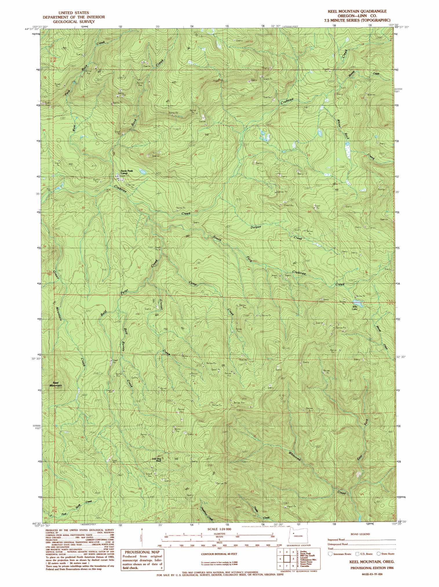
USGS Topo Quad 44122e5 - 1:24,000 scale
| Topo Map Name: | Keel Mountain |
| USGS Topo Quad ID: | 44122e5 |
| Print Size: | ca. 21 1/4" wide x 27" high |
| Southeast Coordinates: | 44.5° N latitude / 122.5° W longitude |
| Map Center Coordinates: | 44.5625° N latitude / 122.5625° W longitude |
| U.S. State: | OR |
| Filename: | o44122e5.jpg |
| Download Map JPG Image: | Keel Mountain topo map 1:24,000 scale |
| Map Type: | Topographic |
| Topo Series: | 7.5´ |
| Map Scale: | 1:24,000 |
| Source of Map Images: | United States Geological Survey (USGS) |
| Alternate Map Versions: |
Keel Mountain OR 1984, updated 1985 Download PDF Buy paper map Keel Mountain OR 2011 Download PDF Buy paper map Keel Mountain OR 2014 Download PDF Buy paper map |
1:24,000 Topo Quads surrounding Keel Mountain
Stayton |
Stout Mountain |
Lyons |
Mill City North |
Elkhorn |
Scio |
Jordan |
Snow Peak |
Mill City South |
Lawhead Creek |
Onehorse Slough |
Lacomb |
Keel Mountain |
Yellowstone Mountain |
Quartzville |
Waterloo |
Sweet Home |
Green Peter |
Cascadia |
Upper Soda |
Crawfordsville |
Chandler Mountain |
Farmers Butte |
Swamp Mountain |
Tidbits Mountain |
> Back to 44122e1 at 1:100,000 scale
> Back to 44122a1 at 1:250,000 scale
> Back to U.S. Topo Maps home
Keel Mountain topo map: Gazetteer
Keel Mountain: Lakes
Billy Lake elevation 727m 2385′Keel Mountain: Pillars
Lost Dog Rock elevation 1022m 3353′Keel Mountain: Streams
Bald Barney Creek elevation 520m 1706′Bald Peter Creek elevation 370m 1213′
Bonnie Creek elevation 655m 2148′
Camp Creek elevation 412m 1351′
Cruiser Creek elevation 451m 1479′
Dorgan Creek elevation 421m 1381′
East Fork Whitcomb Creek elevation 339m 1112′
Rock Creek elevation 344m 1128′
South Fork Crabtree Creek elevation 354m 1161′
West Fork Rock Creek elevation 383m 1256′
White Rock Creek elevation 634m 2080′
Keel Mountain: Summits
Keel Mountain elevation 843m 2765′Keel Mountain digital topo map on disk
Buy this Keel Mountain topo map showing relief, roads, GPS coordinates and other geographical features, as a high-resolution digital map file on DVD: