Long Lake Se Topo Map Wisconsin
To zoom in, hover over the map of Long Lake Se
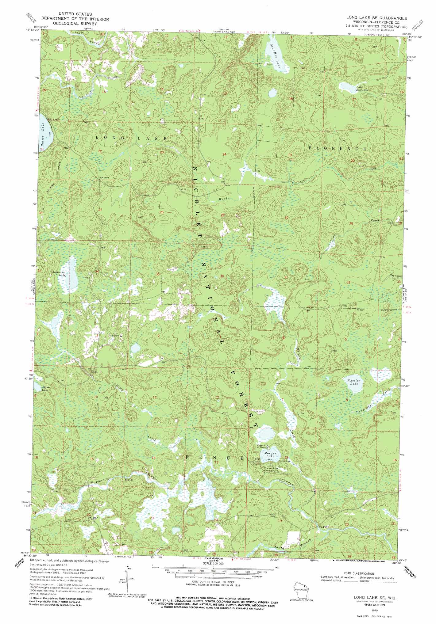
USGS Topo Quad 45088g5 - 1:24,000 scale
| Topo Map Name: | Long Lake Se |
| USGS Topo Quad ID: | 45088g5 |
| Print Size: | ca. 21 1/4" wide x 27" high |
| Southeast Coordinates: | 45.75° N latitude / 88.5° W longitude |
| Map Center Coordinates: | 45.8125° N latitude / 88.5625° W longitude |
| U.S. State: | WI |
| Filename: | o45088g5.jpg |
| Download Map JPG Image: | Long Lake Se topo map 1:24,000 scale |
| Map Type: | Topographic |
| Topo Series: | 7.5´ |
| Map Scale: | 1:24,000 |
| Source of Map Images: | United States Geological Survey (USGS) |
| Alternate Map Versions: |
Long Lake SE WI 1970, updated 1972 Download PDF Buy paper map Long Lake SE WI 1970, updated 1987 Download PDF Buy paper map Long Lake SE WI 2011 Download PDF Buy paper map Long Lake SE WI 2013 Download PDF Buy paper map Long Lake SE WI 2015 Download PDF Buy paper map |
| FStopo: | US Forest Service topo Long Lake SE is available: Download FStopo PDF Download FStopo TIF |
1:24,000 Topo Quads surrounding Long Lake Se
Hagerman Lake |
Iron River |
Gaastra |
Fortune Lakes |
Crystal Falls |
Alvin |
Tipler |
Long Lake Ne |
Naults |
Florence West |
Alvin Se |
Long Lake |
Long Lake Se |
Florence Sw |
Florence Se |
Crandon Ne |
Newald |
Lake Gordon |
Armstrong Creek |
Goodman |
Lake Lucerne |
Laona |
Blackwell |
Goodman Sw |
Coleman Lake |
> Back to 45088e1 at 1:100,000 scale
> Back to 45088a1 at 1:250,000 scale
> Back to U.S. Topo Maps home
Long Lake Se topo map: Gazetteer
Long Lake Se: Lakes
Grandma Lake elevation 464m 1522′Grub Hoe Lake elevation 447m 1466′
Jaquet Lake elevation 462m 1515′
Lake Seventeen elevation 443m 1453′
Morgan Lake elevation 447m 1466′
Wheeler Lake elevation 446m 1463′
Long Lake Se: Parks
Grandma Lake Wetlands State Natural Area elevation 465m 1525′Long Lake Se: Streams
Fay Lake Outlet elevation 448m 1469′Morgan Creek elevation 438m 1437′
Riley Creek elevation 443m 1453′
South Branch Popple River elevation 436m 1430′
Long Lake Se digital topo map on disk
Buy this Long Lake Se topo map showing relief, roads, GPS coordinates and other geographical features, as a high-resolution digital map file on DVD: