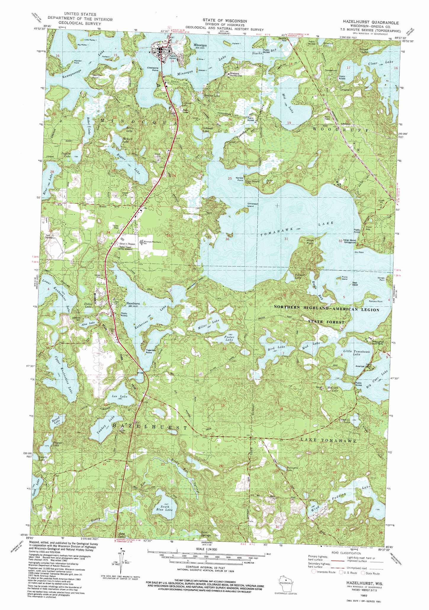
Hazelhurst Topo Map Wisconsin
To zoom in, hover over the map of Hazelhurst
USGS Topo Quad 45089g6 - 1:24,000 scale
| Topo Map Name: | Hazelhurst |
| USGS Topo Quad ID: | 45089g6 |
| Print Size: | ca. 21 1/4" wide x 27" high |
| Southeast Coordinates: | 45.75° N latitude / 89.625° W longitude |
| Map Center Coordinates: | 45.8125° N latitude / 89.6875° W longitude |
| U.S. State: | WI |
| Filename: | o45089g6.jpg |
| Download Map JPG Image: | Hazelhurst topo map 1:24,000 scale |
| Map Type: | Topographic |
| Topo Series: | 7.5´ |
| Map Scale: | 1:24,000 |
| Source of Map Images: | United States Geological Survey (USGS) |
| Alternate Map Versions: |
Hazelhurst WI 1982, updated 1983 Download PDF Buy paper map Hazelhurst WI 2010 Download PDF Buy paper map Hazelhurst WI 2013 Download PDF Buy paper map Hazelhurst WI 2015 Download PDF Buy paper map |
1:24,000 Topo Quads surrounding Hazelhurst
Powell |
Manitowish Lake |
Boulder Junction |
White Sand Lake |
Star Lake |
Lac Du Flambeau |
Fence Lake |
Woodruff |
Sayner |
Saint Germain |
Lac Du Flambeau Sw |
Mercer Lake |
Hazelhurst |
Lake Tomahawk |
Dam Lake |
Pier Lake |
Burrows Lake |
Harshaw |
Mcnaughton |
Reinlander |
Tripoli |
Bradley |
Heafford Junction |
Woodboro |
Lake Julia |
> Back to 45089e1 at 1:100,000 scale
> Back to 45088a1 at 1:250,000 scale
> Back to U.S. Topo Maps home
Hazelhurst topo map: Gazetteer
Hazelhurst: Airports
Circle A Ranch Airport elevation 500m 1640′Hazelhurst: Canals
Hazelhurst Canal elevation 484m 1587′Hazelhurst: Capes
Clawsons Point elevation 498m 1633′Daniels Point elevation 483m 1584′
Doolittle Point elevation 484m 1587′
Dry Point elevation 484m 1587′
Kemps Point elevation 492m 1614′
Madden Point elevation 484m 1587′
Romans Point elevation 488m 1601′
Tigertail Point elevation 488m 1601′
Windy Point elevation 491m 1610′
Hazelhurst: Channels
Tomahawk Thoroughfare elevation 483m 1584′Hazelhurst: Islands
Big Ripley Island elevation 494m 1620′Dead Island elevation 483m 1584′
Fiefield Island elevation 488m 1601′
Fishers Island elevation 483m 1584′
Jossart Island elevation 483m 1584′
Kline Island elevation 483m 1584′
Little Ripley Island elevation 485m 1591′
Olmstead Island elevation 485m 1591′
Picnic Island elevation 483m 1584′
Hazelhurst: Lakes
Alice Lake elevation 481m 1578′Baker Lake elevation 483m 1584′
Berry Lake elevation 483m 1584′
Big Carr Lake elevation 484m 1587′
Bird Lake elevation 484m 1587′
Bogler Lake elevation 484m 1587′
Camp Twenty-one Lake elevation 485m 1591′
Clawson Lake elevation 483m 1584′
Dollar Lake elevation 480m 1574′
Dugout Lake elevation 480m 1574′
Foster Lake elevation 484m 1587′
Inkpot Lake elevation 487m 1597′
Inkwell Lake elevation 484m 1587′
Jerome Lake elevation 483m 1584′
Jyme Lake elevation 485m 1591′
Katherine Lake elevation 483m 1584′
Kawaguesaga Lake elevation 483m 1584′
Lee Lake elevation 482m 1581′
Little Tomahawk Lake elevation 483m 1584′
Lower Kaubashine Lake elevation 479m 1571′
McGrath Lake elevation 484m 1587′
McNutt Lake elevation 483m 1584′
Mid Lake elevation 483m 1584′
Miller Lake elevation 484m 1587′
Minocqua Lake elevation 483m 1584′
Mud Lake elevation 483m 1584′
Papkee Lake elevation 483m 1584′
Porcupine Lake elevation 486m 1594′
Rockpile Pond elevation 484m 1587′
Round Lake elevation 480m 1574′
Schlecht Lake elevation 486m 1594′
South Blue Lake elevation 472m 1548′
Swartz Lake elevation 480m 1574′
Tomahawk Lake elevation 483m 1584′
Upper Kaubashine Lake elevation 479m 1571′
Wind Pudding Lake elevation 483m 1584′
Wind Pudding Lake elevation 483m 1584′
Wolosz Pond elevation 483m 1584′
Yawkey Lake elevation 481m 1578′
Hazelhurst: Parks
Torpy Park elevation 485m 1591′Wind Pudding Lake State Natural Area elevation 483m 1584′
Hazelhurst: Populated Places
Hazelhurst elevation 491m 1610′Minocqua elevation 490m 1607′
Rantz elevation 496m 1627′
Sunflower elevation 486m 1594′
Hazelhurst: Post Offices
Minocqua Post Office elevation 490m 1607′Hazelhurst: Springs
Rocky Run Springs elevation 472m 1548′Scott Springs elevation 470m 1541′
Hazelhurst digital topo map on disk
Buy this Hazelhurst topo map showing relief, roads, GPS coordinates and other geographical features, as a high-resolution digital map file on DVD: