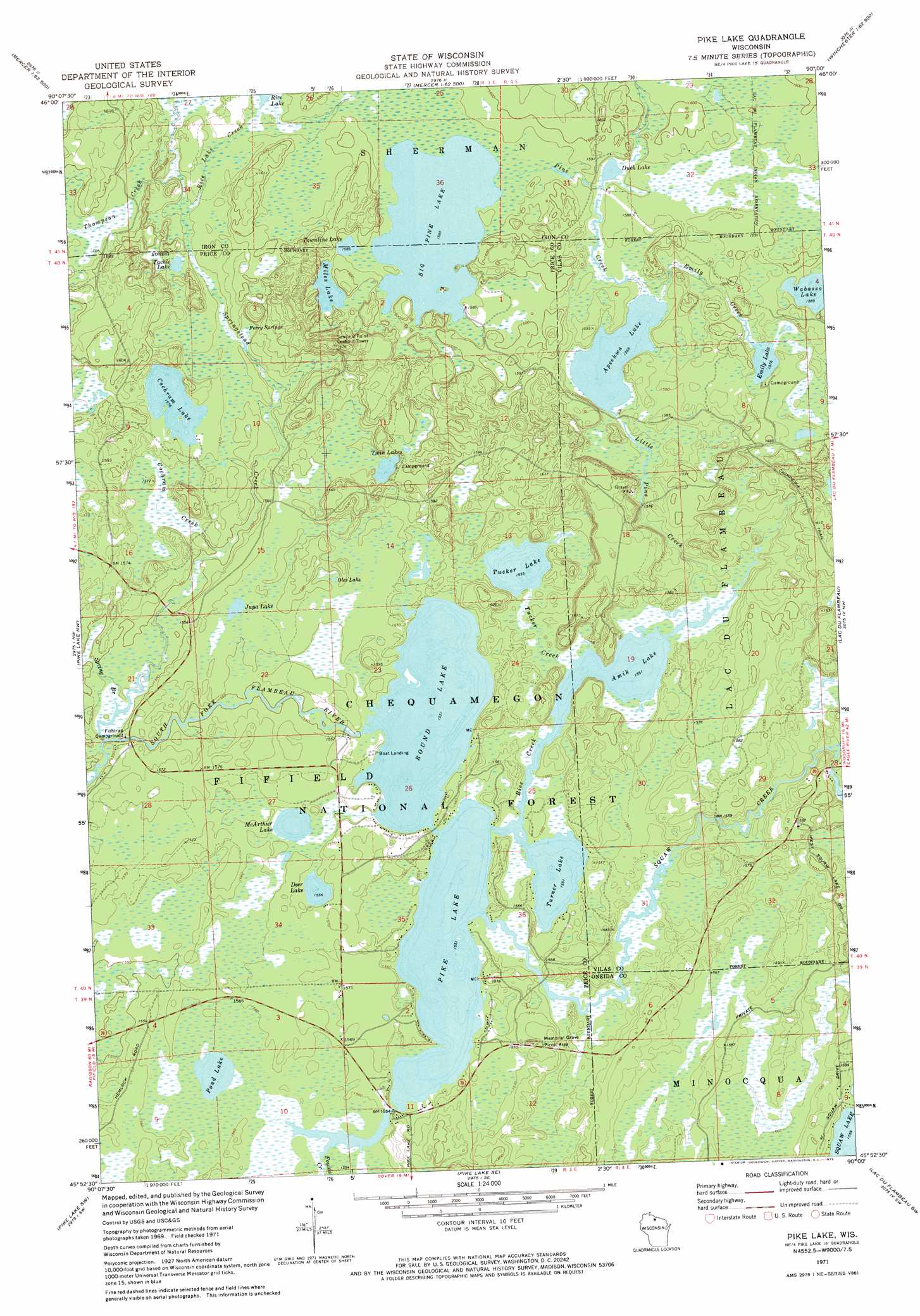
Pike Lake Topo Map Wisconsin
To zoom in, hover over the map of Pike Lake
USGS Topo Quad 45090h1 - 1:24,000 scale
| Topo Map Name: | Pike Lake |
| USGS Topo Quad ID: | 45090h1 |
| Print Size: | ca. 21 1/4" wide x 27" high |
| Southeast Coordinates: | 45.875° N latitude / 90° W longitude |
| Map Center Coordinates: | 45.9375° N latitude / 90.0625° W longitude |
| U.S. State: | WI |
| Filename: | o45090h1.jpg |
| Download Map JPG Image: | Pike Lake topo map 1:24,000 scale |
| Map Type: | Topographic |
| Topo Series: | 7.5´ |
| Map Scale: | 1:24,000 |
| Source of Map Images: | United States Geological Survey (USGS) |
| Alternate Map Versions: |
Pike Lake WI 1971, updated 1973 Download PDF Buy paper map Pike Lake WI 2005, updated 2006 Download PDF Buy paper map Pike Lake WI 2011 Download PDF Buy paper map Pike Lake WI 2013 Download PDF Buy paper map Pike Lake WI 2015 Download PDF Buy paper map |
| FStopo: | US Forest Service topo Pike Lake is available: Download FStopo PDF Download FStopo TIF |
1:24,000 Topo Quads surrounding Pike Lake
Lake Six |
Lake Of The Falls |
Mercer |
Winchester |
Papoose Lake |
Hay Creek Flowage |
Turtle-Flambeau Flowage |
Wilson Lake |
Powell |
Manitowish Lake |
Blockhouse Lake |
Pike Lake Nw |
Pike Lake |
Lac Du Flambeau |
Fence Lake |
Gates Lake |
Pike Lake Sw |
Pike Lake Se |
Lac Du Flambeau Sw |
Mercer Lake |
Cranberry Lake |
Dover |
Thunder Creek |
Pier Lake |
Burrows Lake |
> Back to 45090e1 at 1:100,000 scale
> Back to 45090a1 at 1:250,000 scale
> Back to U.S. Topo Maps home
Pike Lake topo map: Gazetteer
Pike Lake: Airports
Franks Seaplane Base elevation 474m 1555′Pike Lake: Lakes
Amik Lake elevation 472m 1548′Apeekwa Lake elevation 476m 1561′
Big Pine Lake elevation 482m 1581′
Cochran Lake elevation 479m 1571′
Deer Lake elevation 473m 1551′
Duck Lake elevation 479m 1571′
Emily Lake elevation 480m 1574′
Jupa Lake elevation 479m 1571′
McArthur Lake elevation 473m 1551′
Miles Lake elevation 482m 1581′
Oles Lake elevation 478m 1568′
Pike Lake elevation 472m 1548′
Pond Lake elevation 473m 1551′
Rice Lake elevation 479m 1571′
Round Lake elevation 472m 1548′
Tackle Lake elevation 480m 1574′
Townline Lake elevation 482m 1581′
Tucker Lake elevation 473m 1551′
Turner Lake elevation 472m 1548′
Twin Lakes elevation 479m 1571′
Wabasso Lake elevation 483m 1584′
Pike Lake: Parks
Bass Lake Preserve State Natural Area elevation 487m 1597′Memorial Grove Hemlocks State Natural Area elevation 482m 1581′
Memorial Grove Picnic Area elevation 482m 1581′
Tucker Lake Hemlocks State Natural Area elevation 475m 1558′
Pike Lake: Springs
Ferry Springs elevation 477m 1564′Pike Lake: Streams
Cochran Creek elevation 471m 1545′Emily Creek elevation 479m 1571′
Foulds Creek elevation 473m 1551′
Little Pine Creek elevation 473m 1551′
Pine Creek elevation 478m 1568′
Rice Creek elevation 473m 1551′
Rice Lake Creek elevation 478m 1568′
Spring Branch elevation 468m 1535′
Springstead Creek elevation 467m 1532′
Squaw Creek elevation 472m 1548′
Thompson Creek elevation 478m 1568′
Tucker Creek elevation 472m 1548′
Pike Lake digital topo map on disk
Buy this Pike Lake topo map showing relief, roads, GPS coordinates and other geographical features, as a high-resolution digital map file on DVD: