Waugh Mountain Topo Map Idaho
To zoom in, hover over the map of Waugh Mountain
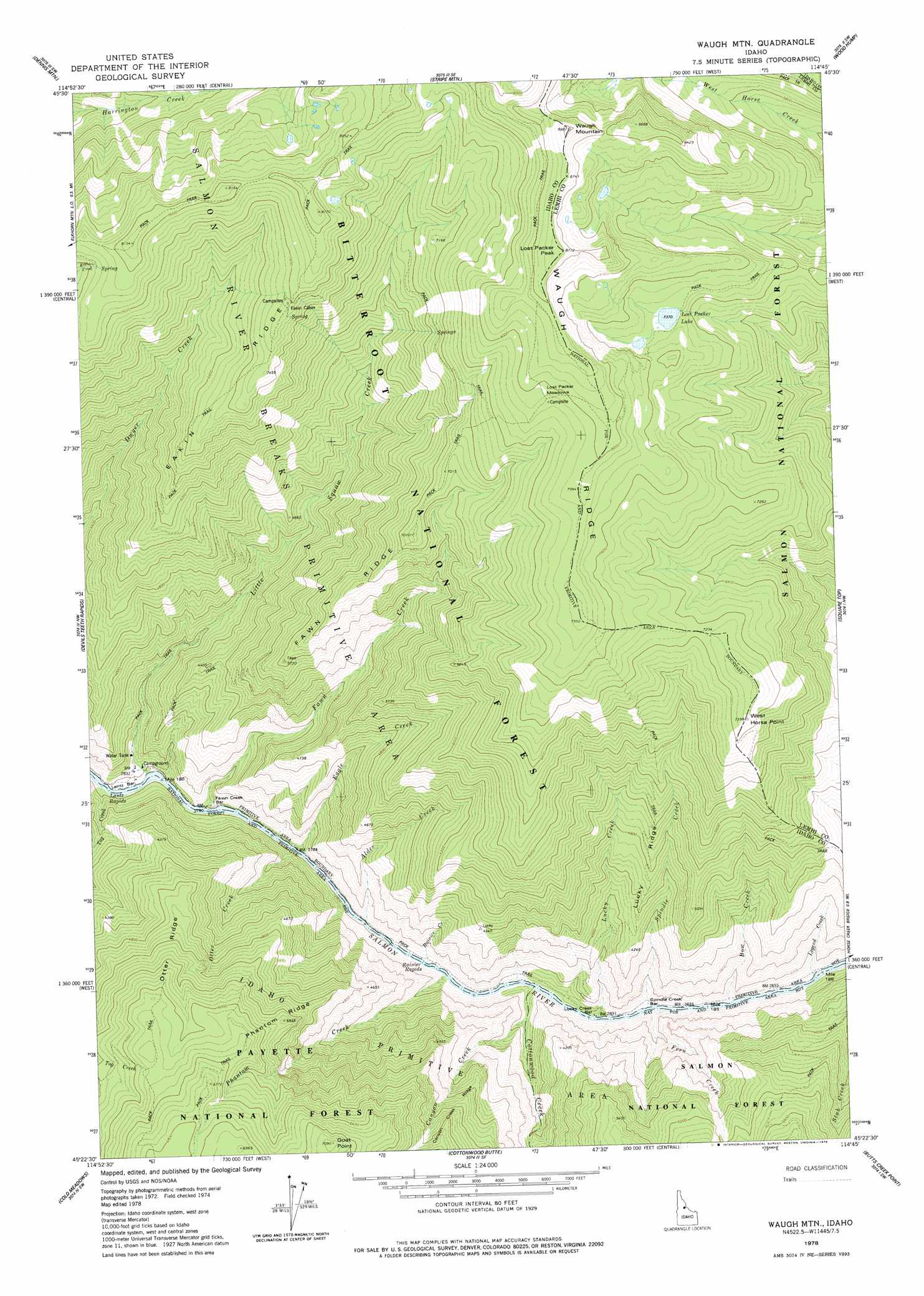
USGS Topo Quad 45114d7 - 1:24,000 scale
| Topo Map Name: | Waugh Mountain |
| USGS Topo Quad ID: | 45114d7 |
| Print Size: | ca. 21 1/4" wide x 27" high |
| Southeast Coordinates: | 45.375° N latitude / 114.75° W longitude |
| Map Center Coordinates: | 45.4375° N latitude / 114.8125° W longitude |
| U.S. State: | ID |
| Filename: | o45114d7.jpg |
| Download Map JPG Image: | Waugh Mountain topo map 1:24,000 scale |
| Map Type: | Topographic |
| Topo Series: | 7.5´ |
| Map Scale: | 1:24,000 |
| Source of Map Images: | United States Geological Survey (USGS) |
| Alternate Map Versions: |
Waugh Mountain ID 1978, updated 1978 Download PDF Buy paper map Waugh Mountain ID 1999, updated 2002 Download PDF Buy paper map Waugh Mountain ID 2011 Download PDF Buy paper map Waugh Mountain ID 2013 Download PDF Buy paper map |
| FStopo: | US Forest Service topo Waugh Mountain is available: Download FStopo PDF Download FStopo TIF |
1:24,000 Topo Quads surrounding Waugh Mountain
Spread Creek Point |
Sabe Mountain |
Magruder Mountain |
Beaver Jack Mountain |
Nez Perce Peak |
Sheep Hill |
Dennis Mountain |
Stripe Mountain |
Wood Hump |
Blue Joint |
Arctic Point |
Devils Teeth Rapids |
Waugh Mountain |
Square Top |
Horse Creek Butte |
Wapiti Creek |
Cold Meadows |
Cottonwood Butte |
Butts Creek Point |
Long Tom Mountain |
Acorn Butte |
Vinegar Hill |
Papoose Peak |
Aggipah Mountain |
Mount Mcguire |
> Back to 45114a1 at 1:100,000 scale
> Back to 45114a1 at 1:250,000 scale
> Back to U.S. Topo Maps home
Waugh Mountain topo map: Gazetteer
Waugh Mountain: Bars
Fawn Creek Bar elevation 874m 2867′Lantz Bar elevation 853m 2798′
Lucky Creek Bar elevation 886m 2906′
Spindle Creek Bar elevation 917m 3008′
Waugh Mountain: Flats
Lost Packer Meadows elevation 2421m 7942′Waugh Mountain: Lakes
Lost Packer Lake elevation 2248m 7375′Waugh Mountain: Rapids
Lantz Rapids elevation 839m 2752′Rainier Rapids elevation 863m 2831′
Waugh Mountain: Ridges
Eakin Ridge elevation 2154m 7066′Fawn Ridge elevation 1923m 6309′
Lucky Ridge elevation 1583m 5193′
Otter Ridge elevation 1604m 5262′
Phantom Ridge elevation 1778m 5833′
Waugh Ridge elevation 2540m 8333′
Waugh Mountain: Streams
Alder Creek elevation 879m 2883′Bow Creek elevation 869m 2851′
Canyon Creek elevation 918m 3011′
Cottonwood Creek elevation 865m 2837′
Eagle Creek elevation 865m 2837′
Fawn Creek elevation 862m 2828′
Fern Creek elevation 864m 2834′
Legend Creek elevation 875m 2870′
Little Squaw Creek elevation 853m 2798′
Lucky Creek elevation 891m 2923′
Otter Creek elevation 852m 2795′
Phantom Creek elevation 865m 2837′
Rainier Creek elevation 871m 2857′
Spindle Creek elevation 877m 2877′
Tag Creek elevation 840m 2755′
Waugh Mountain: Summits
Goat Point elevation 2150m 7053′Lost Packer Peak elevation 2639m 8658′
Waugh Mountain elevation 2683m 8802′
West Horse Point elevation 2249m 7378′
Waugh Mountain digital topo map on disk
Buy this Waugh Mountain topo map showing relief, roads, GPS coordinates and other geographical features, as a high-resolution digital map file on DVD: