Piquett Mountain Topo Map Montana
To zoom in, hover over the map of Piquett Mountain
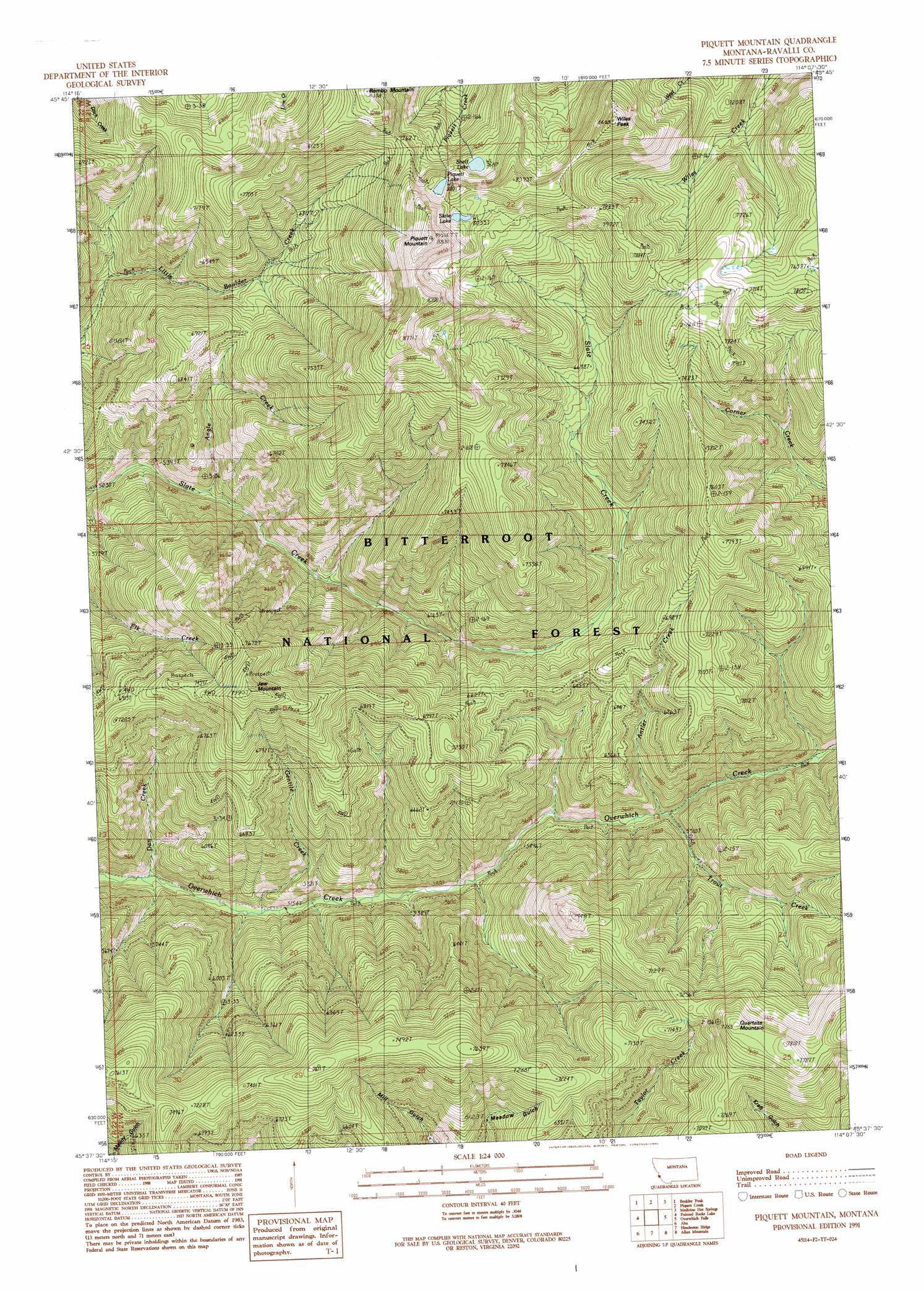
USGS Topo Quad 45114f2 - 1:24,000 scale
| Topo Map Name: | Piquett Mountain |
| USGS Topo Quad ID: | 45114f2 |
| Print Size: | ca. 21 1/4" wide x 27" high |
| Southeast Coordinates: | 45.625° N latitude / 114.125° W longitude |
| Map Center Coordinates: | 45.6875° N latitude / 114.1875° W longitude |
| U.S. State: | MT |
| Filename: | o45114f2.jpg |
| Download Map JPG Image: | Piquett Mountain topo map 1:24,000 scale |
| Map Type: | Topographic |
| Topo Series: | 7.5´ |
| Map Scale: | 1:24,000 |
| Source of Map Images: | United States Geological Survey (USGS) |
| Alternate Map Versions: |
Piquett Mountain MT 1991, updated 1991 Download PDF Buy paper map Piquett Mountain MT 1991, updated 1994 Download PDF Buy paper map Piquett Mountain MT 1998, updated 2002 Download PDF Buy paper map Piquett Mountain MT 2011 Download PDF Buy paper map Piquett Mountain MT 2014 Download PDF Buy paper map |
| FStopo: | US Forest Service topo Piquett Mountain is available: Download FStopo PDF Download FStopo TIF |
1:24,000 Topo Quads surrounding Piquett Mountain
Tin Cup Lake |
Trapper Peak |
Burnt Ridge |
Robbins Gulch |
French Basin |
Mount Jerusalem |
Boulder Peak |
Piquett Creek |
Medicine Hot Springs |
Sula |
Bare Cone |
Painted Rocks Lake |
Piquett Mountain |
Overwhich Falls |
Lost Trail Pass |
Horse Creek Pass |
Alta |
Henderson Ridge |
Allan Mountain |
Gibbonsville |
Tincup Hill |
Shoup |
Ulysses |
Ulysses Mountain |
North Fork |
> Back to 45114e1 at 1:100,000 scale
> Back to 45114a1 at 1:250,000 scale
> Back to U.S. Topo Maps home
Piquett Mountain topo map: Gazetteer
Piquett Mountain: Lakes
Piquett Lake elevation 2440m 8005′Shelf Lake elevation 2344m 7690′
Slate Lake elevation 2451m 8041′
Piquett Mountain: Mines
Jew Mountain Mine elevation 2175m 7135′Piquett Mountain: Streams
Angle Creek elevation 1608m 5275′Antler Creek elevation 1672m 5485′
Dan Creek elevation 1544m 5065′
Gentile Creek elevation 1566m 5137′
Kyke Creek elevation 1590m 5216′
Trout Creek elevation 1669m 5475′
Piquett Mountain: Summits
Jew Mountain elevation 2430m 7972′Piquett Mountain elevation 2681m 8795′
Quartzite Mountain elevation 2363m 7752′
Rombo Mountain elevation 2541m 8336′
Wiles Peak elevation 2614m 8576′
Piquett Mountain digital topo map on disk
Buy this Piquett Mountain topo map showing relief, roads, GPS coordinates and other geographical features, as a high-resolution digital map file on DVD: