Black Hawk Mountain Topo Map Idaho
To zoom in, hover over the map of Black Hawk Mountain
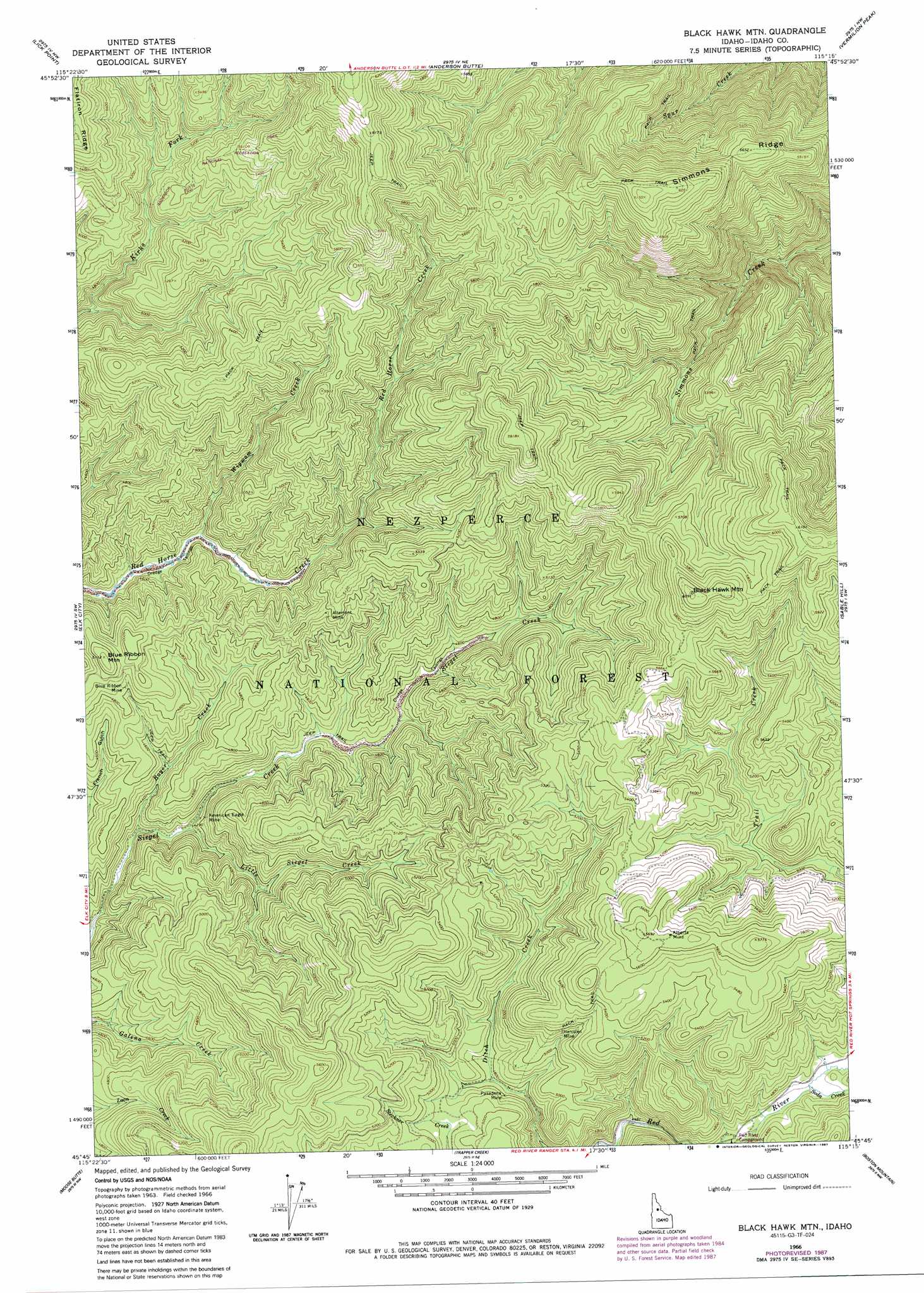
USGS Topo Quad 45115g3 - 1:24,000 scale
| Topo Map Name: | Black Hawk Mountain |
| USGS Topo Quad ID: | 45115g3 |
| Print Size: | ca. 21 1/4" wide x 27" high |
| Southeast Coordinates: | 45.75° N latitude / 115.25° W longitude |
| Map Center Coordinates: | 45.8125° N latitude / 115.3125° W longitude |
| U.S. State: | ID |
| Filename: | o45115g3.jpg |
| Download Map JPG Image: | Black Hawk Mountain topo map 1:24,000 scale |
| Map Type: | Topographic |
| Topo Series: | 7.5´ |
| Map Scale: | 1:24,000 |
| Source of Map Images: | United States Geological Survey (USGS) |
| Alternate Map Versions: |
Black Hawk Mtn ID 1966, updated 1968 Download PDF Buy paper map Black Hawk Mtn ID 1966, updated 1985 Download PDF Buy paper map Black Hawk Mtn ID 1966, updated 1987 Download PDF Buy paper map Black Hawk Mountain ID 1995, updated 1999 Download PDF Buy paper map Black Hawk Mountain ID 2011 Download PDF Buy paper map Black Hawk Mountain ID 2013 Download PDF Buy paper map |
| FStopo: | US Forest Service topo Black Hawk Mountain is available: Download FStopo PDF Download FStopo TIF |
1:24,000 Topo Quads surrounding Black Hawk Mountain
Goddard Point |
Stillman Point |
Selway Falls |
Fog Mountain |
Mink Peak |
Iron Mountain |
Lick Point |
Anderson Butte |
Vermilion Peak |
Running Lake |
Cener Star Mountain |
Elk City |
Black Hawk Mountain |
Sable Hill |
Green Mountain |
Orogrande |
Moose Butte |
Trapper Creek |
Boston Mountain |
Spread Creek Point |
Silver Spur Ridge |
Dixie |
Whitewater Ranch |
Hida Point |
Sheep Hill |
> Back to 45115e1 at 1:100,000 scale
> Back to 45114a1 at 1:250,000 scale
> Back to U.S. Topo Maps home
Black Hawk Mountain topo map: Gazetteer
Black Hawk Mountain: Mines
Alberta Mine elevation 1716m 5629′Altemont Mine elevation 1513m 4963′
American Eagle Mine elevation 1365m 4478′
Blue Ribbon Mine elevation 1478m 4849′
Hercules Mine elevation 1573m 5160′
Pasadena Mine elevation 1457m 4780′
Black Hawk Mountain: Ridges
Simmons Ridge elevation 1870m 6135′Black Hawk Mountain: Streams
Boyer Creek elevation 1305m 4281′Little Siegel Creek elevation 1316m 4317′
Soda Creek elevation 1428m 4685′
Wigwam Creek elevation 1375m 4511′
Black Hawk Mountain: Summits
Black Hawk Mountain elevation 1854m 6082′Blue Ribbon Mountain elevation 1553m 5095′
Black Hawk Mountain digital topo map on disk
Buy this Black Hawk Mountain topo map showing relief, roads, GPS coordinates and other geographical features, as a high-resolution digital map file on DVD: