Grand Ronde Topo Map Oregon
To zoom in, hover over the map of Grand Ronde
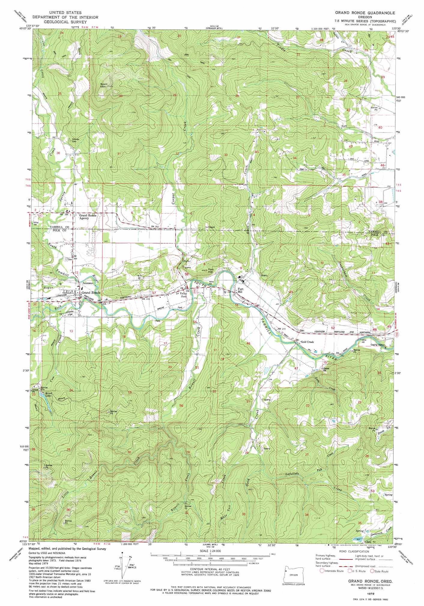
USGS Topo Quad 45123a5 - 1:24,000 scale
| Topo Map Name: | Grand Ronde |
| USGS Topo Quad ID: | 45123a5 |
| Print Size: | ca. 21 1/4" wide x 27" high |
| Southeast Coordinates: | 45° N latitude / 123.5° W longitude |
| Map Center Coordinates: | 45.0625° N latitude / 123.5625° W longitude |
| U.S. State: | OR |
| Filename: | o45123a5.jpg |
| Download Map JPG Image: | Grand Ronde topo map 1:24,000 scale |
| Map Type: | Topographic |
| Topo Series: | 7.5´ |
| Map Scale: | 1:24,000 |
| Source of Map Images: | United States Geological Survey (USGS) |
| Alternate Map Versions: |
Grand Ronde OR 1979, updated 1983 Download PDF Buy paper map Grand Ronde OR 2011 Download PDF Buy paper map Grand Ronde OR 2014 Download PDF Buy paper map |
1:24,000 Topo Quads surrounding Grand Ronde
Beaver |
Blaine |
Dovre Peak |
Trask Mountain |
Fairdale |
Hebo |
Niagara Creek |
Springer Mountain |
Stony Mountain |
Muddy Valley |
Dolph |
Midway |
Grand Ronde |
Sheridan |
Ballston |
Stott Mountain |
Warnicke Creek |
Laurel Mountain |
Socialist Valley |
Dallas |
Euchre Mountain |
Valsetz |
Fanno Ridge |
Falls City |
Airlie North |
> Back to 45123a1 at 1:100,000 scale
> Back to 45122a1 at 1:250,000 scale
> Back to U.S. Topo Maps home
Grand Ronde topo map: Gazetteer
Grand Ronde: Airports
Andersons Airfield elevation 112m 367′Grand Ronde: Dams
Mountain Springs Ranch Dam elevation 265m 869′Ornoname 9 Dam elevation 115m 377′
Grand Ronde: Populated Places
Fort Hill Census Designated Place elevation 88m 288′Grand Ronde elevation 105m 344′
Grand Ronde Agency elevation 113m 370′
Valley Junction elevation 87m 285′
Grand Ronde: Post Offices
Butler Post Office (historical) elevation 100m 328′Grand Ronde Post Office elevation 105m 344′
Grand Ronde: Reservoirs
Bailey Reservoir elevation 288m 944′Brush Lake elevation 175m 574′
Burns Reservoir elevation 151m 495′
Mountain Springs Ranch Reservoir elevation 265m 869′
Suttner Reservoir elevation 93m 305′
Grand Ronde: Streams
Agency Creek elevation 104m 341′Carter Creek elevation 154m 505′
Cosper Creek elevation 85m 278′
Cow Creek elevation 100m 328′
Doane Creek elevation 74m 242′
Folk Creek elevation 182m 597′
Gold Creek elevation 80m 262′
Indian Creek elevation 95m 311′
Klees Creek elevation 88m 288′
Lady Creek elevation 80m 262′
Lafollett Creek elevation 145m 475′
Little Rowell Creek elevation 164m 538′
Mule Tail Creek elevation 123m 403′
Rock Creek elevation 93m 305′
Rogue River elevation 98m 321′
Rowell Creek elevation 86m 282′
Tindle Creek elevation 83m 272′
Grand Ronde: Summits
Fort Hill elevation 181m 593′Spirit Mountain elevation 536m 1758′
Grand Ronde digital topo map on disk
Buy this Grand Ronde topo map showing relief, roads, GPS coordinates and other geographical features, as a high-resolution digital map file on DVD: