Sheridan Topo Map Oregon
To zoom in, hover over the map of Sheridan
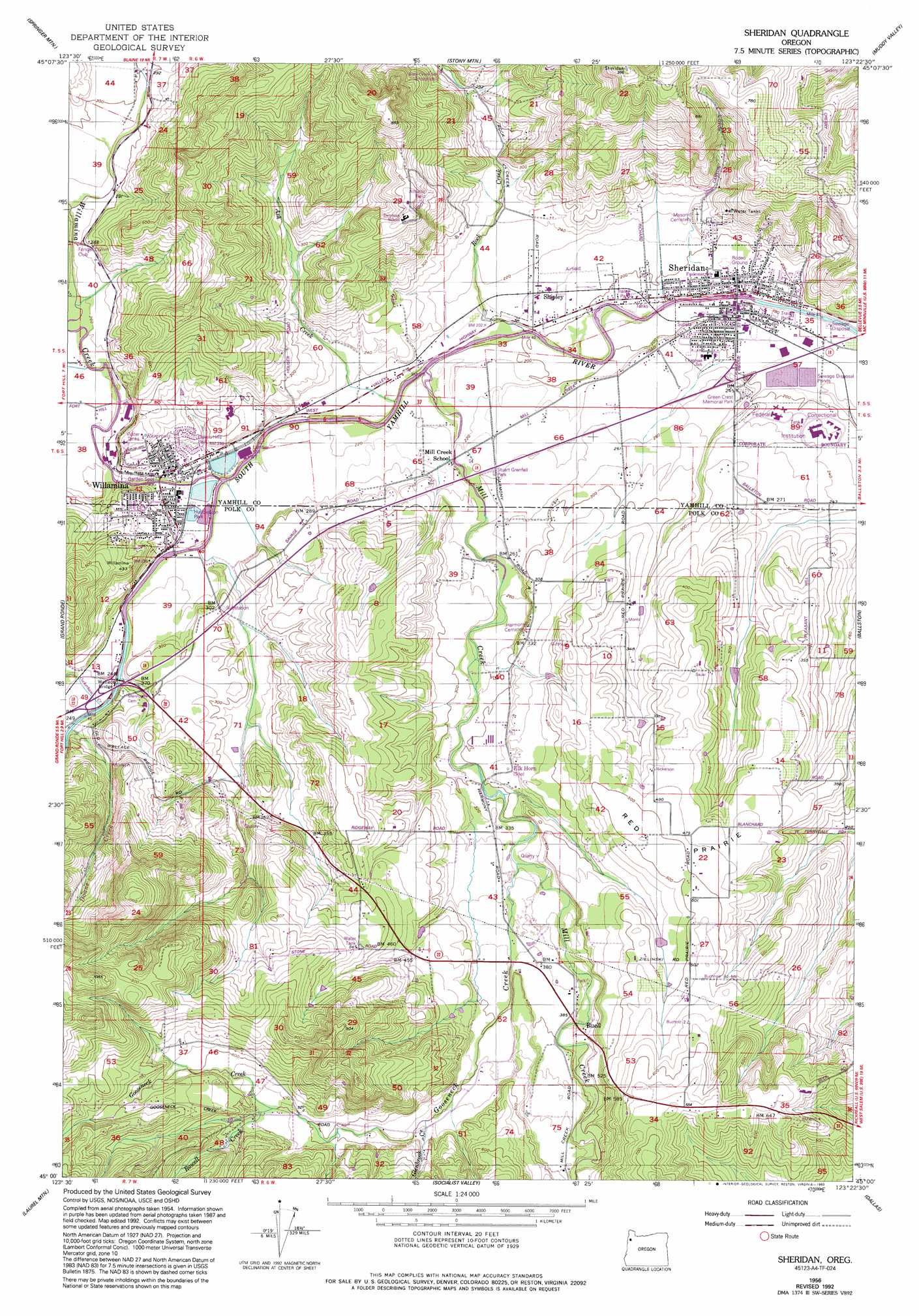
USGS Topo Quad 45123a4 - 1:24,000 scale
| Topo Map Name: | Sheridan |
| USGS Topo Quad ID: | 45123a4 |
| Print Size: | ca. 21 1/4" wide x 27" high |
| Southeast Coordinates: | 45° N latitude / 123.375° W longitude |
| Map Center Coordinates: | 45.0625° N latitude / 123.4375° W longitude |
| U.S. State: | OR |
| Filename: | o45123a4.jpg |
| Download Map JPG Image: | Sheridan topo map 1:24,000 scale |
| Map Type: | Topographic |
| Topo Series: | 7.5´ |
| Map Scale: | 1:24,000 |
| Source of Map Images: | United States Geological Survey (USGS) |
| Alternate Map Versions: |
Sheridan OR 1956, updated 1956 Download PDF Buy paper map Sheridan OR 1956, updated 1971 Download PDF Buy paper map Sheridan OR 1956, updated 1978 Download PDF Buy paper map Sheridan OR 1956, updated 1993 Download PDF Buy paper map Sheridan OR 2011 Download PDF Buy paper map Sheridan OR 2014 Download PDF Buy paper map |
1:24,000 Topo Quads surrounding Sheridan
Blaine |
Dovre Peak |
Trask Mountain |
Fairdale |
Carlton |
Niagara Creek |
Springer Mountain |
Stony Mountain |
Muddy Valley |
Mcminnville |
Midway |
Grand Ronde |
Sheridan |
Ballston |
Amity |
Warnicke Creek |
Laurel Mountain |
Socialist Valley |
Dallas |
Rickreall |
Valsetz |
Fanno Ridge |
Falls City |
Airlie North |
Monmouth |
> Back to 45123a1 at 1:100,000 scale
> Back to 45122a1 at 1:250,000 scale
> Back to U.S. Topo Maps home
Sheridan topo map: Gazetteer
Sheridan: Airports
Sheridan Airfield elevation 64m 209′Sheridan: Bridges
Wallace Bridge elevation 71m 232′Sheridan: Dams
Joe Crow Dam elevation 87m 285′Pacific Plywood Corporation Dam elevation 69m 226′
Sheridan: Flats
Red Prairie elevation 156m 511′Sheridan: Lakes
Downing Pond elevation 131m 429′Jones Pond elevation 180m 590′
Osborn Pond elevation 192m 629′
Sheridan: Parks
Buell County Park elevation 110m 360′Garden Spot Park elevation 69m 226′
Huddleston Pond Park elevation 71m 232′
Lamson Park elevation 78m 255′
Oaken Hills Memorial Park elevation 74m 242′
Sheridan City Park elevation 58m 190′
Stuart Grenfell County Park elevation 73m 239′
Tina Miller Memorial Park elevation 76m 249′
Triangle Park elevation 74m 242′
Sheridan: Populated Places
Buell elevation 121m 396′Sheridan elevation 56m 183′
Willamina elevation 71m 232′
Sheridan: Post Offices
Buell Post Office (historical) elevation 121m 396′Elk Horn Post Office (historical) elevation 101m 331′
Firholm Post Office (historical) elevation 96m 314′
Sheridan Post Office elevation 56m 183′
Willamina Post Office elevation 71m 232′
Sheridan: Reservoirs
Hart Reservoir elevation 137m 449′Joe Crow Reservoir elevation 87m 285′
Pacific Plywood Log Pond elevation 71m 232′
Willamina Reservoir elevation 72m 236′
Sheridan: Streams
Ash Creek elevation 60m 196′Cockerham Creek elevation 74m 242′
Glenbrook Creek elevation 137m 449′
Gooseneck Creek elevation 96m 314′
Meadow Creek elevation 138m 452′
Mill Creek elevation 61m 200′
Red Prairie Creek elevation 90m 295′
Rock Creek elevation 58m 190′
Rowell Creek elevation 162m 531′
Willamina Creek elevation 67m 219′
Sheridan digital topo map on disk
Buy this Sheridan topo map showing relief, roads, GPS coordinates and other geographical features, as a high-resolution digital map file on DVD: