Hay Creek Flowage Topo Map Wisconsin
To zoom in, hover over the map of Hay Creek Flowage
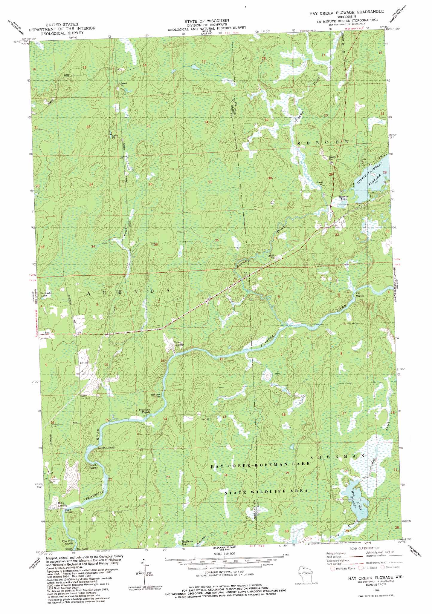
USGS Topo Quad 46090a3 - 1:24,000 scale
| Topo Map Name: | Hay Creek Flowage |
| USGS Topo Quad ID: | 46090a3 |
| Print Size: | ca. 21 1/4" wide x 27" high |
| Southeast Coordinates: | 46° N latitude / 90.25° W longitude |
| Map Center Coordinates: | 46.0625° N latitude / 90.3125° W longitude |
| U.S. State: | WI |
| Filename: | o46090a3.jpg |
| Download Map JPG Image: | Hay Creek Flowage topo map 1:24,000 scale |
| Map Type: | Topographic |
| Topo Series: | 7.5´ |
| Map Scale: | 1:24,000 |
| Source of Map Images: | United States Geological Survey (USGS) |
| Alternate Map Versions: |
Hay Creek Flowage WI 1984, updated 1984 Download PDF Buy paper map Hay Creek Flowage WI 2010 Download PDF Buy paper map Hay Creek Flowage WI 2013 Download PDF Buy paper map Hay Creek Flowage WI 2015 Download PDF Buy paper map |
1:24,000 Topo Quads surrounding Hay Creek Flowage
Mount Whittlesey |
Upson |
Turntable Creek |
Pine Lake |
Lake Evelyn |
Glidden |
Augustine Lake |
Lake Six |
Lake Of The Falls |
Mercer |
Peeksville |
Butternut |
Hay Creek Flowage |
Turtle-Flambeau Flowage |
Wilson Lake |
Butternut Lake |
Park Falls |
Blockhouse Lake |
Pike Lake Nw |
Pike Lake |
Lugerville |
Priest Lake |
Gates Lake |
Pike Lake Sw |
Pike Lake Se |
> Back to 46090a1 at 1:100,000 scale
> Back to 46090a1 at 1:250,000 scale
> Back to U.S. Topo Maps home
Hay Creek Flowage topo map: Gazetteer
Hay Creek Flowage: Dams
Hay Creek D12.185 Dam elevation 471m 1545′Hay Creek Flowage: Lakes
McKaskel Lake elevation 491m 1610′Minnow Lake elevation 481m 1578′
Hay Creek Flowage: Pillars
Bear Skull Rock elevation 475m 1558′Hay Creek Flowage: Populated Places
Holts Landing elevation 471m 1545′Petes Landing elevation 476m 1561′
Hay Creek Flowage: Rapids
Pine Tree Rapids elevation 459m 1505′Quinns Rapids elevation 464m 1522′
Simmons Rapids elevation 463m 1519′
Stubbs Rapids elevation 460m 1509′
Hay Creek Flowage: Reservoirs
Hay Creek Flowage elevation 472m 1548′Hay Creek Flowage: Streams
Deer Creek elevation 460m 1509′Swamp Creek elevation 462m 1515′
Hay Creek Flowage digital topo map on disk
Buy this Hay Creek Flowage topo map showing relief, roads, GPS coordinates and other geographical features, as a high-resolution digital map file on DVD: