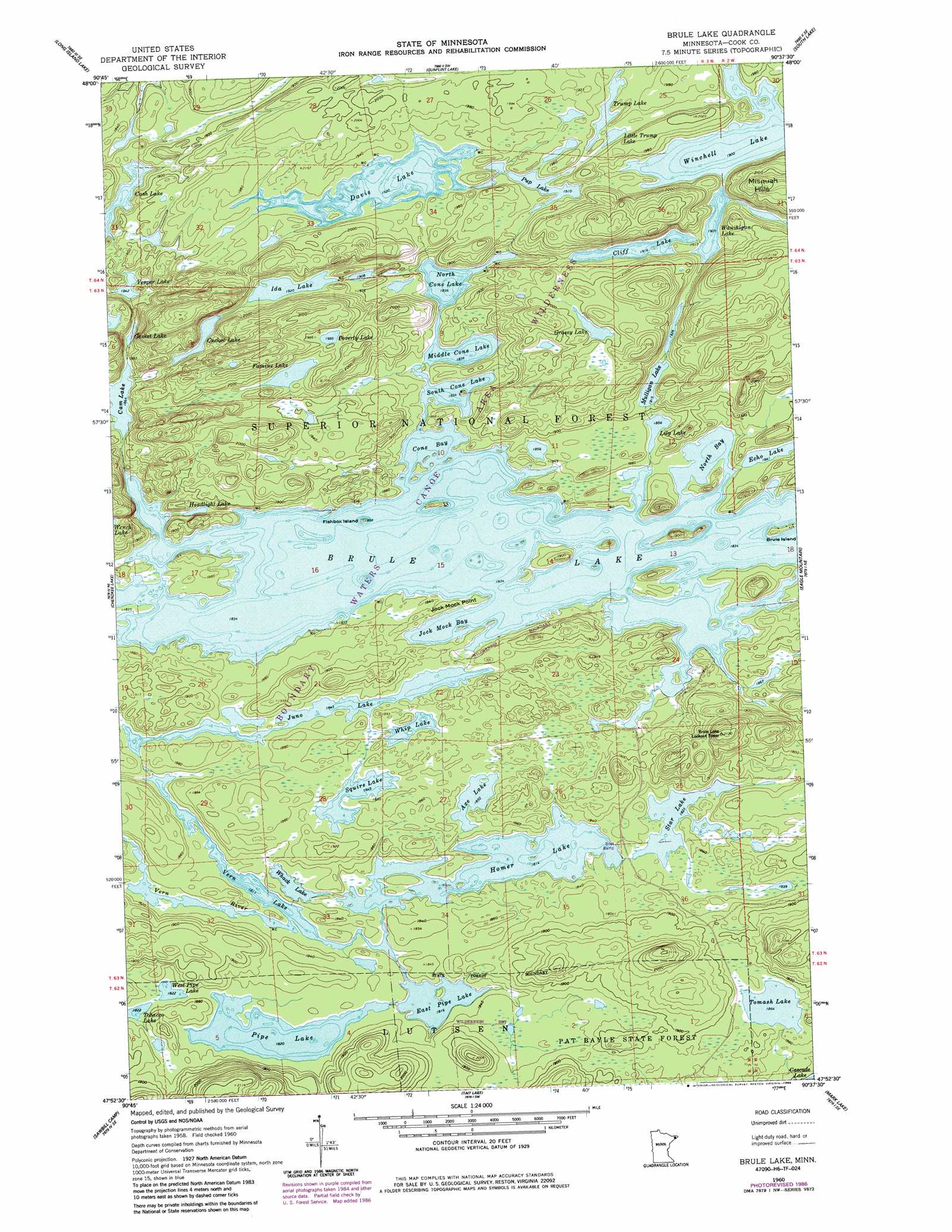
Brule Lake Topo Map Minnesota
To zoom in, hover over the map of Brule Lake
USGS Topo Quad 47090h6 - 1:24,000 scale
| Topo Map Name: | Brule Lake |
| USGS Topo Quad ID: | 47090h6 |
| Print Size: | ca. 21 1/4" wide x 27" high |
| Southeast Coordinates: | 47.875° N latitude / 90.625° W longitude |
| Map Center Coordinates: | 47.9375° N latitude / 90.6875° W longitude |
| U.S. State: | MN |
| Filename: | o47090h6.jpg |
| Download Map JPG Image: | Brule Lake topo map 1:24,000 scale |
| Map Type: | Topographic |
| Topo Series: | 7.5´ |
| Map Scale: | 1:24,000 |
| Source of Map Images: | United States Geological Survey (USGS) |
| Alternate Map Versions: |
Brule Lake MN 1960, updated 1962 Download PDF Buy paper map Brule Lake MN 1960, updated 1963 Download PDF Buy paper map Brule Lake MN 1960, updated 1977 Download PDF Buy paper map Brule Lake MN 1960, updated 1982 Download PDF Buy paper map Brule Lake MN 1960, updated 1986 Download PDF Buy paper map Brule Lake MN 2011 Download PDF Buy paper map Brule Lake MN 2013 Download PDF Buy paper map Brule Lake MN 2016 Download PDF Buy paper map |
| FStopo: | US Forest Service topo Brule Lake is available: Download FStopo PDF Download FStopo TIF |
1:24,000 Topo Quads surrounding Brule Lake
Munker Island |
Conners Island |
|||
Gillis Lake |
Long Island Lake |
Gunflint Lake |
South Lake |
Hungry Jack Lake |
Kelso Mountain |
Cherokee Lake |
Brule Lake |
Eagle Mountain |
Lima Mountain |
Beth Lake |
Sawbill Camp |
Tait Lake |
Mark Lake |
Devil Track Lake |
Toohey Lake |
Honeymoon Mountain |
Lutsen |
Deer Yard Lake |
> Back to 47090e1 at 1:100,000 scale
> Back to 47090a1 at 1:250,000 scale
> Back to U.S. Topo Maps home
Brule Lake topo map: Gazetteer
Brule Lake: Bays
Cone Bay elevation 559m 1833′Jock Mock Bay elevation 559m 1833′
North Bay elevation 559m 1833′
Brule Lake: Capes
Jock Mock Point elevation 561m 1840′Brule Lake: Islands
Brule Island elevation 561m 1840′Fishbox Island elevation 561m 1840′
Brule Lake: Lakes
Axe Lake elevation 564m 1850′Brule Lake elevation 559m 1833′
Cam Lake elevation 568m 1863′
Cash Lake elevation 558m 1830′
Cliff Lake elevation 584m 1916′
Cucko Lake elevation 589m 1932′
Davis Lake elevation 585m 1919′
East Pipe Lake elevation 554m 1817′
Famine Lake elevation 595m 1952′
Gasket Lake elevation 568m 1863′
Grassy Lake elevation 607m 1991′
Headlight Lake elevation 560m 1837′
Homer Lake elevation 553m 1814′
Ida Lake elevation 585m 1919′
Juno Lake elevation 562m 1843′
Lily Lake elevation 566m 1856′
Little Trump Lake elevation 588m 1929′
Middle Cone Lake elevation 560m 1837′
Mulligan Lake elevation 584m 1916′
North Cone Lake elevation 560m 1837′
Pipe Lake elevation 555m 1820′
Poverty Lake elevation 605m 1984′
Pup Lake elevation 582m 1909′
South Cone Lake elevation 559m 1833′
Squire Lake elevation 564m 1850′
Star Lake elevation 556m 1824′
Tobacco Lake elevation 556m 1824′
Tomash Lake elevation 568m 1863′
Trump Lake elevation 590m 1935′
Vern Lake elevation 552m 1811′
Vesper Lake elevation 562m 1843′
Wanihigan Lake elevation 581m 1906′
West Pipe Lake elevation 555m 1820′
Whack Lake elevation 554m 1817′
Whip Lake elevation 564m 1850′
Brule Lake digital topo map on disk
Buy this Brule Lake topo map showing relief, roads, GPS coordinates and other geographical features, as a high-resolution digital map file on DVD: