Finley Creek Topo Map Washington
To zoom in, hover over the map of Finley Creek
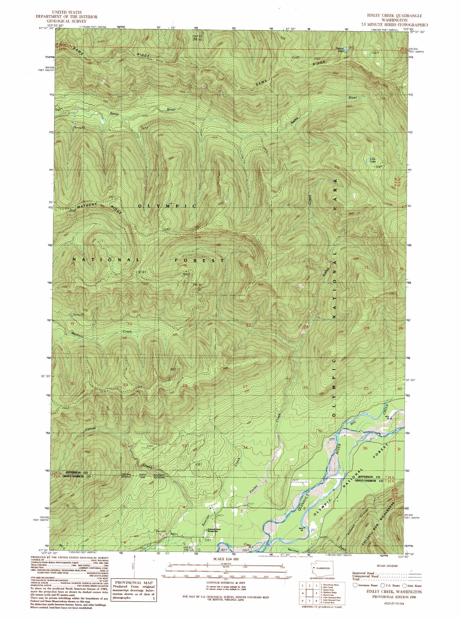
USGS Topo Quad 47123e7 - 1:24,000 scale
| Topo Map Name: | Finley Creek |
| USGS Topo Quad ID: | 47123e7 |
| Print Size: | ca. 21 1/4" wide x 27" high |
| Southeast Coordinates: | 47.5° N latitude / 123.75° W longitude |
| Map Center Coordinates: | 47.5625° N latitude / 123.8125° W longitude |
| U.S. State: | WA |
| Filename: | o47123e7.jpg |
| Download Map JPG Image: | Finley Creek topo map 1:24,000 scale |
| Map Type: | Topographic |
| Topo Series: | 7.5´ |
| Map Scale: | 1:24,000 |
| Source of Map Images: | United States Geological Survey (USGS) |
| Alternate Map Versions: |
Finley Creek WA 1990, updated 1990 Download PDF Buy paper map Finley Creek WA 2011 Download PDF Buy paper map Finley Creek WA 2014 Download PDF Buy paper map |
| FStopo: | US Forest Service topo Finley Creek is available: Download FStopo PDF Download FStopo TIF |
1:24,000 Topo Quads surrounding Finley Creek
Spruce Mountain |
Owl Mountain |
Mount Tom |
Mount Olympus |
Mount Queets |
Stequaleho Creek |
Kloochman Rock |
Bob Creek |
Kimta Peak |
Mount Christie |
Salmon River East |
Matheny Ridge |
Finley Creek |
Bunch Lake |
Mount Hoquiam |
Thimble Mountain |
Quinault Lake West |
Quinault Lake East |
Colonel Bob |
Wynoochee Lake |
Macafee Hill |
Stevens Creek |
Burnt Hill |
Larsen Creek |
Grisdale |
> Back to 47123e1 at 1:100,000 scale
> Back to 47122a1 at 1:250,000 scale
> Back to U.S. Topo Maps home
Finley Creek topo map: Gazetteer
Finley Creek: Lakes
Lilly Lake elevation 963m 3159′Round Lake elevation 1022m 3353′
Finley Creek: Ridges
Sams Ridge elevation 978m 3208′Finley Creek: Streams
Big Creek elevation 82m 269′Inner Creek elevation 72m 236′
Kestner Creek elevation 63m 206′
Finley Creek: Summits
Finley Peak elevation 1044m 3425′Finley Creek digital topo map on disk
Buy this Finley Creek topo map showing relief, roads, GPS coordinates and other geographical features, as a high-resolution digital map file on DVD: