Flaxville Topo Map Montana
To zoom in, hover over the map of Flaxville
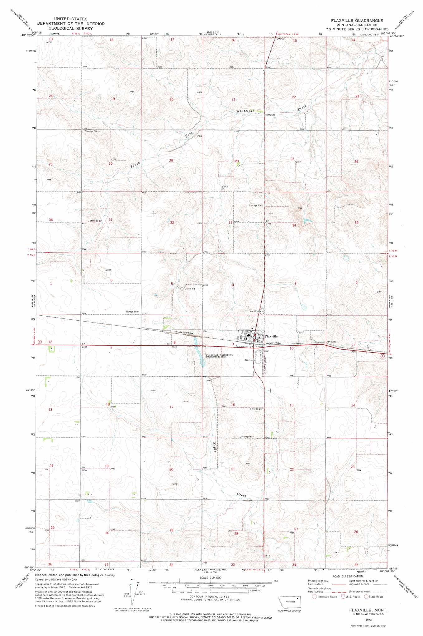
USGS Topo Quad 48105g2 - 1:24,000 scale
| Topo Map Name: | Flaxville |
| USGS Topo Quad ID: | 48105g2 |
| Print Size: | ca. 21 1/4" wide x 27" high |
| Southeast Coordinates: | 48.75° N latitude / 105.125° W longitude |
| Map Center Coordinates: | 48.8125° N latitude / 105.1875° W longitude |
| U.S. State: | MT |
| Filename: | o48105g2.jpg |
| Download Map JPG Image: | Flaxville topo map 1:24,000 scale |
| Map Type: | Topographic |
| Topo Series: | 7.5´ |
| Map Scale: | 1:24,000 |
| Source of Map Images: | United States Geological Survey (USGS) |
| Alternate Map Versions: |
Flaxville MT 1973, updated 1976 Download PDF Buy paper map Flaxville MT 2011 Download PDF Buy paper map Flaxville MT 2014 Download PDF Buy paper map |
1:24,000 Topo Quads surrounding Flaxville
Scobey Nw |
Si Merrell Slough |
Whitetail |
Goodale Coulee |
Daleview |
Scobey |
Madoc |
Flaxville |
Navajo |
Redstone |
Cabarett Coulee |
Line Coulee |
Pleasant Prairie Nw |
Pleasant Prairie Ne |
Soo Nw |
Nielsen Coulee |
Bredette |
Pleasant Prairie Sw |
Pleasant Prairie |
Soo |
> Back to 48105e1 at 1:100,000 scale
> Back to 48104a1 at 1:250,000 scale
> Back to U.S. Topo Maps home
Flaxville topo map: Gazetteer
Flaxville: Parks
Flaxville Waterfowl Production Area elevation 827m 2713′Flaxville: Populated Places
Flaxville elevation 848m 2782′Flaxville: Post Offices
Flaxville Post Office elevation 847m 2778′Flaxville: Wells
35N49E01ADCD01 Well elevation 848m 2782′35N49E13BAAD01 Well elevation 851m 2791′
35N49E13DDAB01 Well elevation 848m 2782′
35N50E06BCBD01 Well elevation 842m 2762′
35N50E07ADDB01 Well elevation 843m 2765′
35N50E08BADD01 Well elevation 844m 2769′
35N50E09ACAD01 Well elevation 847m 2778′
35N50E09BADB01 Well elevation 848m 2782′
35N50E10ACBB01 Well elevation 842m 2762′
35N50E14CBBB01 Well elevation 846m 2775′
35N50E14DDBD01 Well elevation 848m 2782′
35N50E15ABBC01 Well elevation 845m 2772′
35N50E15ABBC02 Well elevation 845m 2772′
35N50E15ABCB01 Well elevation 846m 2775′
35N50E16BABC01 Well elevation 846m 2775′
35N50E19CCDA01 Well elevation 845m 2772′
35N50E20DADB01 Well elevation 822m 2696′
35N50E22CBBA01 Well elevation 818m 2683′
35N50E26CCCA01 Well elevation 803m 2634′
35N50E27AADD01 Well elevation 823m 2700′
35N50E28ADCA01 Well elevation 808m 2650′
35N50E28ADCA02 Well elevation 807m 2647′
35N50E28CCBA01 Well elevation 843m 2765′
35N50E29AADD01 Well elevation 818m 2683′
35N50E29DDAB01 Well elevation 840m 2755′
35N50E30BCAA01 Well elevation 849m 2785′
36N49E24DADA01 Well elevation 821m 2693′
36N50E20DDDB01 Well elevation 788m 2585′
36N50E21AAAD01 Well elevation 789m 2588′
36N50E26AACD01 Well elevation 784m 2572′
36N50E28DBBA01 Well elevation 793m 2601′
36N50E31DADD01 Well elevation 845m 2772′
Flaxville digital topo map on disk
Buy this Flaxville topo map showing relief, roads, GPS coordinates and other geographical features, as a high-resolution digital map file on DVD:
Eastern Montana & Western North Dakota
Buy digital topo maps: Eastern Montana & Western North Dakota