Frostproof Topo Map Florida
To zoom in, hover over the map of Frostproof
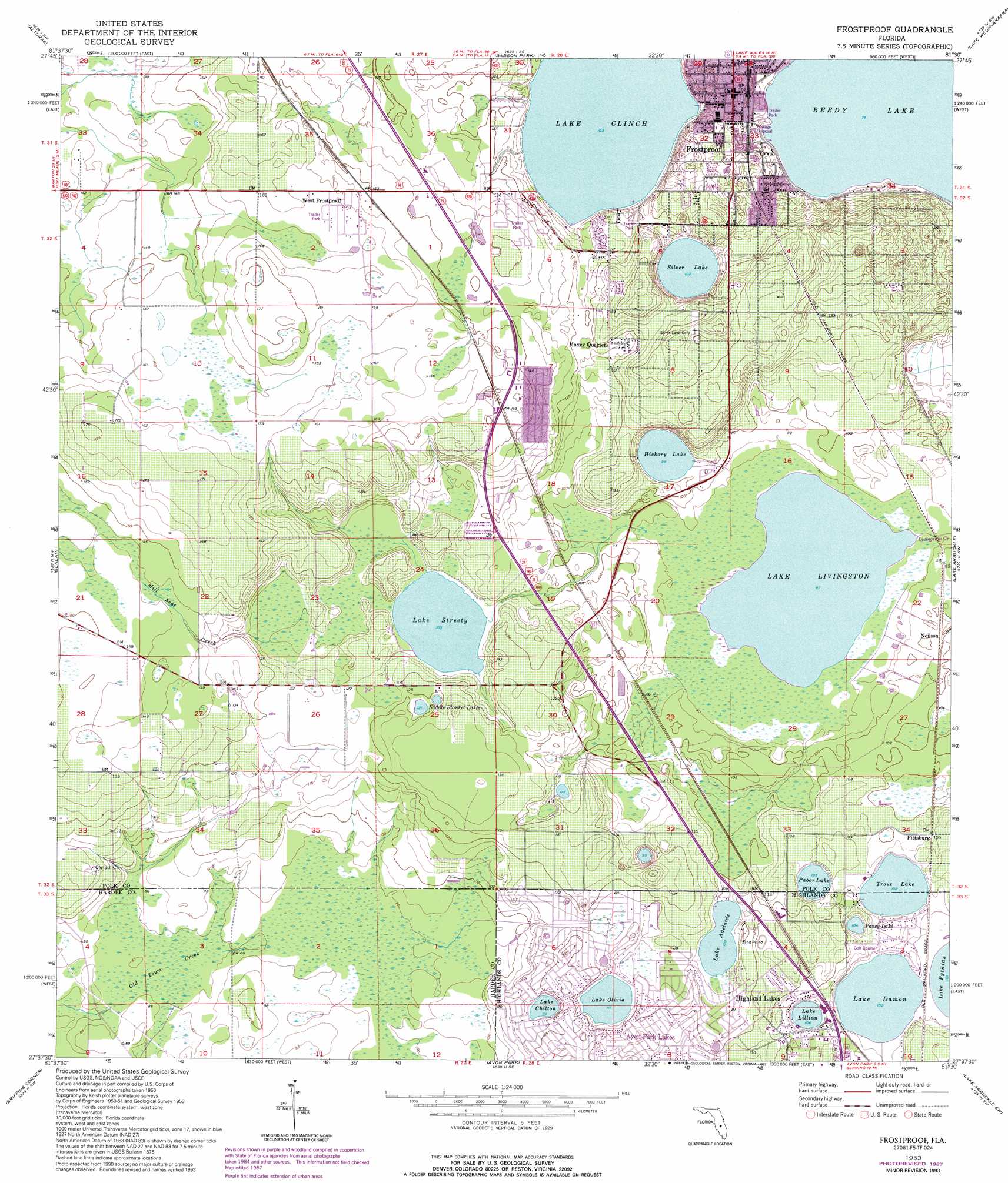
USGS Topo Quad 27081f5 - 1:24,000 scale
| Topo Map Name: | Frostproof |
| USGS Topo Quad ID: | 27081f5 |
| Print Size: | ca. 21 1/4" wide x 27" high |
| Southeast Coordinates: | 27.625° N latitude / 81.5° W longitude |
| Map Center Coordinates: | 27.6875° N latitude / 81.5625° W longitude |
| U.S. State: | FL |
| Filename: | O27081F5.jpg |
| Download Map JPG Image: | Frostproof topo map 1:24,000 scale |
| Map Type: | Topographic |
| Topo Series: | 7.5´ |
| Map Scale: | 1:24,000 |
| Source of Map Images: | United States Geological Survey (USGS) |
| Alternate Map Versions: |
Frostproof FL 1953, updated 1954 Download PDF Buy paper map Frostproof FL 1953, updated 1973 Download PDF Buy paper map Frostproof FL 1953, updated 1977 Download PDF Buy paper map Frostproof FL 1953, updated 1987 Download PDF Buy paper map Frostproof FL 1953, updated 1993 Download PDF Buy paper map Frostproof FL 2012 Download PDF Buy paper map Frostproof FL 2015 Download PDF Buy paper map |
1:24,000 Topo Quads surrounding Frostproof
Bartow |
Eloise |
Lake Wales |
Hesperides |
Lake Weohyakapka Ne |
Homeland |
Alturas |
Babson Park |
Lake Weohyakapka |
Lake Weohyakpka Se |
Bowling Green |
Bereah |
Frostproof |
Lake Arbuckle |
Lake Arbuckle Ne |
Wauchula |
Griffins Corner |
Avon Park |
Lake Arbuckle Sw |
Lake Arbuckle Se |
Zolfo Springs |
Sweetwater |
Crewsville |
Sebring |
Lorida |
> Back to 27081e1 at 1:100,000 scale
> Back to 27080a1 at 1:250,000 scale
> Back to U.S. Topo Maps home
Frostproof topo map: Gazetteer
Frostproof: Airports
Griffins Main Office Heliport elevation 38m 124′Walker Memorial Medical Center Heliport elevation 35m 114′
Frostproof: Lakes
Hickory Lake elevation 30m 98′Lake Adelaide elevation 30m 98′
Lake Arcola elevation 35m 114′
Lake Chilton elevation 34m 111′
Lake Clinch elevation 31m 101′
Lake Damon elevation 31m 101′
Lake Lillian elevation 32m 104′
Lake Livingston elevation 26m 85′
Lake Olivia elevation 35m 114′
Lake Streety elevation 32m 104′
Pabor Lake elevation 31m 101′
Pansy Lake elevation 31m 101′
Saddle Blanket Lakes elevation 37m 121′
Silver Lake elevation 31m 101′
Trout Lake elevation 31m 101′
Frostproof: Populated Places
Avon Park Lakes elevation 41m 134′Frostproof elevation 34m 111′
Hickory Lake Estates Mobile Home Park elevation 30m 98′
Highland Lakes elevation 38m 124′
Lakefront Trailer Park elevation 44m 144′
Maxcy Quarters elevation 36m 118′
Neilson elevation 30m 98′
Pittsburg elevation 32m 104′
Reedy Haven Trailer Park elevation 26m 85′
Selph's Mobile Home Village elevation 26m 85′
West Frostproof elevation 47m 154′
Whispering Pines Mobile Home Court elevation 44m 144′
Frostproof: Post Offices
Frostproof Post Office elevation 33m 108′Frostproof: Streams
Mill Seat Creek elevation 33m 108′Frostproof digital topo map on disk
Buy this Frostproof topo map showing relief, roads, GPS coordinates and other geographical features, as a high-resolution digital map file on DVD: