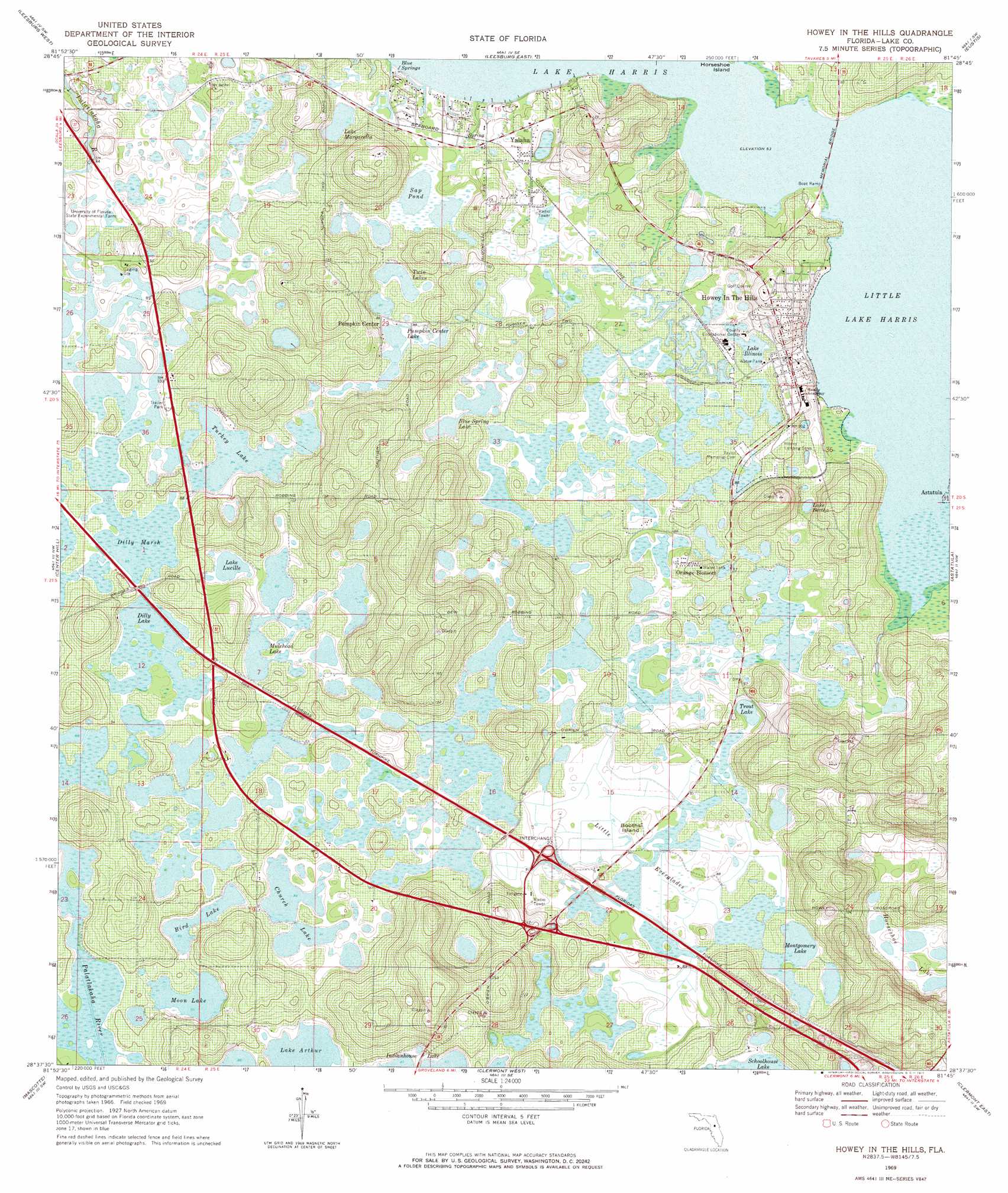
Hewey In The Hills Topo Map Florida
To zoom in, hover over the map of Hewey In The Hills
USGS Topo Quad 28081f7 - 1:24,000 scale
| Topo Map Name: | Hewey In The Hills |
| USGS Topo Quad ID: | 28081f7 |
| Print Size: | ca. 21 1/4" wide x 27" high |
| Southeast Coordinates: | 28.625° N latitude / 81.75° W longitude |
| Map Center Coordinates: | 28.6875° N latitude / 81.8125° W longitude |
| U.S. State: | FL |
| Filename: | O28081F7.jpg |
| Download Map JPG Image: | Hewey In The Hills topo map 1:24,000 scale |
| Map Type: | Topographic |
| Topo Series: | 7.5´ |
| Map Scale: | 1:24,000 |
| Source of Map Images: | United States Geological Survey (USGS) |
| Alternate Map Versions: |
Howey In The Hills FL 1969, updated 1971 Download PDF Buy paper map Howey In The Hills FL 1969, updated 1971 Download PDF Buy paper map Howey In The Hills FL 2012 Download PDF Buy paper map Howey In The Hills FL 2015 Download PDF Buy paper map |
1:24,000 Topo Quads surrounding Hewey In The Hills
Oxford |
Lady Lake |
Emeralda Island |
Umatilla |
Paisley |
Wildwood |
Leesburg West |
Leesburg East |
Eustis |
Sorrento |
Bushnell |
Center Hill |
Hewey In The Hills |
Astatula |
Apopka |
Webster |
Mascotte |
Clermont West |
Clermont East |
Winter Garden |
Clay Sink |
Bay Lake |
Lake Nellie |
Lake Louisa |
Windermere |
> Back to 28081e1 at 1:100,000 scale
> Back to 28080a1 at 1:250,000 scale
> Back to U.S. Topo Maps home
Hewey In The Hills topo map: Gazetteer
Hewey In The Hills: Airports
Florida Flying Gators Ultralight Airport elevation 28m 91′Howey Landing Strip elevation 30m 98′
Hewey In The Hills: Bridges
Memorial Bridge elevation 19m 62′Hewey In The Hills: Crossings
Interchange 27 elevation 28m 91′Hewey In The Hills: Islands
Booths Island elevation 29m 95′Hewey In The Hills: Lakes
Bird Lake elevation 26m 85′Blue Spring Lake elevation 23m 75′
Church Lake elevation 25m 82′
Crown Lake elevation 26m 85′
Dilly Lake elevation 26m 85′
Lake Annabelle Reed elevation 24m 78′
Lake Arthur elevation 25m 82′
Lake Bertha elevation 28m 91′
Lake Illinois elevation 24m 78′
Lake Jewel elevation 25m 82′
Lake Lucille elevation 25m 82′
Lake Margaretta elevation 23m 75′
Lake Monarch elevation 26m 85′
Little Lake Harris elevation 19m 62′
Montgomery Lake elevation 25m 82′
Moon Lake elevation 26m 85′
Mulehead Lake elevation 25m 82′
Pumpkin Center Lake elevation 24m 78′
Royal Lake elevation 26m 85′
Sap Pond elevation 25m 82′
Trout Lake elevation 25m 82′
Turkey Lake elevation 25m 82′
Twin Lakes elevation 25m 82′
Hewey In The Hills: Parks
Griffin Stormwater Park elevation 19m 62′Hewey In The Hills: Populated Places
Howie In The Hills elevation 37m 121′Orange Blossom elevation 30m 98′
Pumpkin Center elevation 25m 82′
Spanish Village Mobile Home Park elevation 30m 98′
Woodlands at Church Lake Mobile Home Park elevation 27m 88′
Yalaha elevation 23m 75′
Hewey In The Hills: Post Offices
Howey - in - the - Hills Post Office elevation 29m 95′Howey-In-The-Hills Post Office elevation 25m 82′
Yahala Post Office elevation 25m 82′
Hewey In The Hills: Springs
Blue Springs elevation 20m 65′Hewey In The Hills: Swamps
Dilly Marsh elevation 26m 85′Little Everglades elevation 26m 85′
Hewey In The Hills digital topo map on disk
Buy this Hewey In The Hills topo map showing relief, roads, GPS coordinates and other geographical features, as a high-resolution digital map file on DVD: