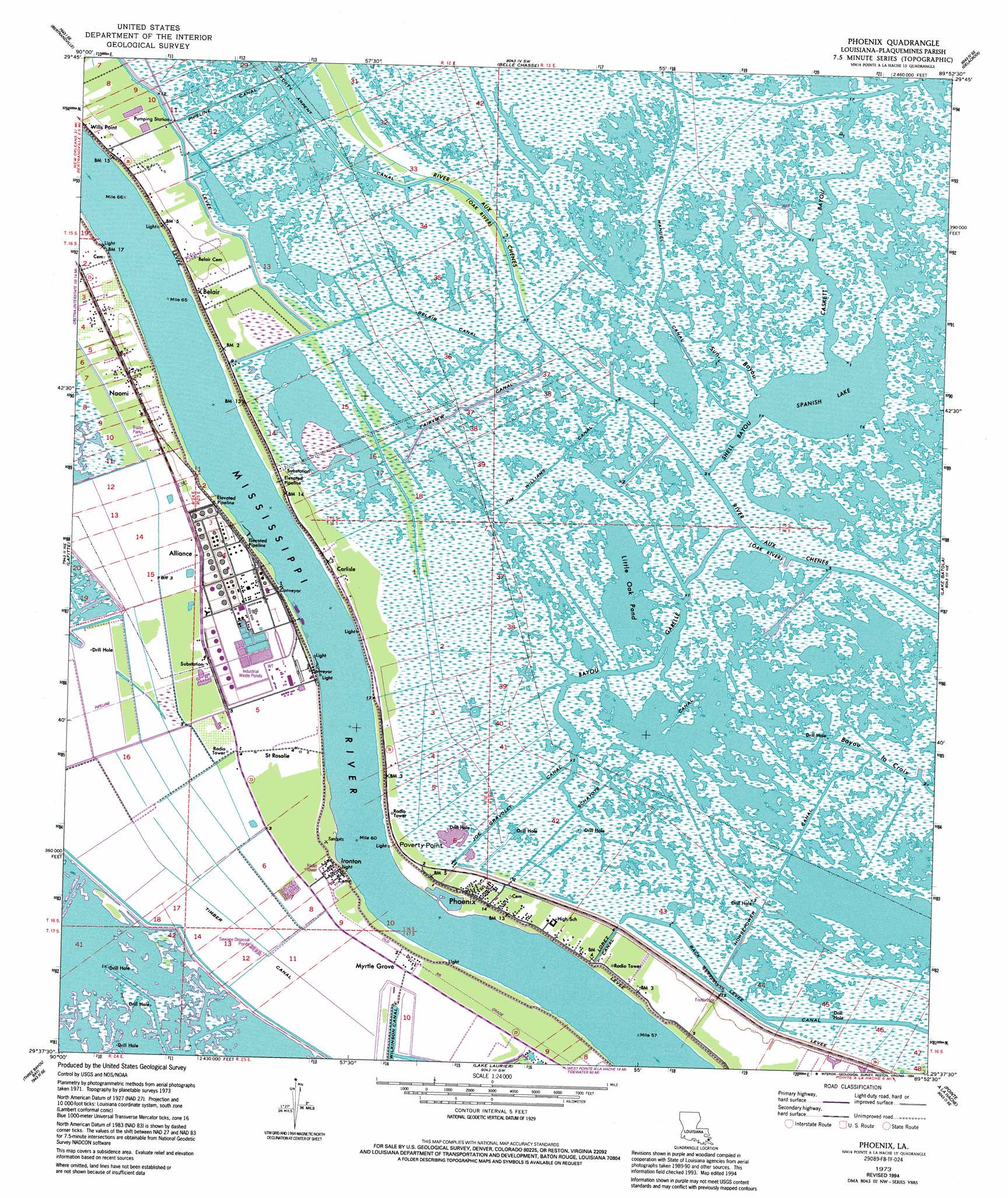
Phoenix Topo Map Louisiana
To zoom in, hover over the map of Phoenix
USGS Topo Quad 29089f8 - 1:24,000 scale
| Topo Map Name: | Phoenix |
| USGS Topo Quad ID: | 29089f8 |
| Print Size: | ca. 21 1/4" wide x 27" high |
| Southeast Coordinates: | 29.625° N latitude / 89.875° W longitude |
| Map Center Coordinates: | 29.6875° N latitude / 89.9375° W longitude |
| U.S. State: | LA |
| Filename: | o29089f8.jpg |
| Download Map JPG Image: | Phoenix topo map 1:24,000 scale |
| Map Type: | Topographic |
| Topo Series: | 7.5´ |
| Map Scale: | 1:24,000 |
| Source of Map Images: | United States Geological Survey (USGS) |
| Alternate Map Versions: |
Phoenix LA 1973, updated 1976 Download PDF Buy paper map Phoenix LA 1973, updated 1989 Download PDF Buy paper map Phoenix LA 1973, updated 1994 Download PDF Buy paper map Phoenix LA 1973, updated 1994 Download PDF Buy paper map Phoenix LA 2012 Download PDF Buy paper map Phoenix LA 2015 Download PDF Buy paper map |
1:24,000 Topo Quads surrounding Phoenix
New Orleans West |
New Orleans East |
Chalmette |
Martello Castle |
Proctor Point |
Lake Cataouatche East |
Bertrandville |
Belle Chasse |
Delacroix |
Yscloskey |
Barataria |
Lafitte |
Phoenix |
Lake Batola |
Lake Cuatro Caballo |
Bay L'Ours |
Three Bayou Bay |
Lake Laurier |
Pointe A La Hache |
Happy Jack |
Golden Meadow Farms |
Bay Dosgris |
Wilkinson Bay |
Bay Batiste |
Port Sulphur |
> Back to 29089e1 at 1:100,000 scale
> Back to 29088a1 at 1:250,000 scale
> Back to U.S. Topo Maps home
Phoenix topo map: Gazetteer
Phoenix: Canals
Belair Canal elevation 0m 0′Fairview Canal elevation 0m 0′
Horsepower Canal elevation 0m 0′
Jim Williams Canal elevation 0m 0′
Joe Gravolet Canal elevation 0m 0′
Lorez Canal elevation 0m 0′
Manuel Canal elevation 1m 3′
Schayots Canal elevation 0m 0′
Timber Canal elevation 0m 0′
Phoenix: Capes
Poverty Point elevation 1m 3′Phoenix: Guts
Bayou Garelle elevation 0m 0′Caskett Bayou elevation -2m -7′
Shell Bayou elevation -2m -7′
Sun Bayou elevation 0m 0′
Phoenix: Lakes
Little Oak Pond elevation 0m 0′Spanish Lake elevation -2m -7′
Phoenix: Levees
Alliance Revetment elevation 2m 6′Harlem Revetment elevation 2m 6′
Monsecour Revetment elevation 2m 6′
Myrtle Grove Revetment elevation 2m 6′
Phoenix: Oilfields
Phoenix Gas Field elevation 1m 3′Spanish Lake Gas Field elevation 1m 3′
Spanish Lake Oil Field elevation 0m 0′
Phoenix: Populated Places
Alliance elevation 2m 6′Belair elevation 1m 3′
Burbridge elevation 1m 3′
Burnbridge elevation 1m 3′
Carlisle elevation 2m 6′
Ironton elevation 1m 3′
La Reussite elevation 2m 6′
Monsecour elevation 1m 3′
Myrtle Grove elevation 1m 3′
Naomi elevation 2m 6′
Phoenix elevation 1m 3′
Reussite elevation 2m 6′
Saint Rosalie elevation 1m 3′
Phoenix: Post Offices
Carlisle Post Office elevation 2m 6′Phoenix digital topo map on disk
Buy this Phoenix topo map showing relief, roads, GPS coordinates and other geographical features, as a high-resolution digital map file on DVD:
Gulf Coast (LA, MS, AL, FL) & Southwestern Georgia
Buy digital topo maps: Gulf Coast (LA, MS, AL, FL) & Southwestern Georgia
 & Southwestern Georgia map DVD")