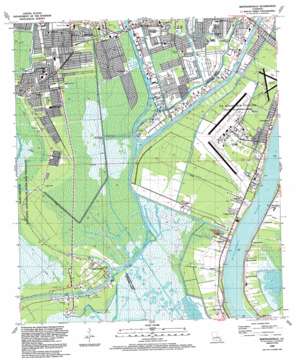
Bertrandville Topo Map Louisiana
To zoom in, hover over the map of Bertrandville
USGS Topo Quad 29090g1 - 1:24,000 scale
| Topo Map Name: | Bertrandville |
| USGS Topo Quad ID: | 29090g1 |
| Print Size: | ca. 21 1/4" wide x 27" high |
| Southeast Coordinates: | 29.75° N latitude / 90° W longitude |
| Map Center Coordinates: | 29.8125° N latitude / 90.0625° W longitude |
| U.S. State: | LA |
| Filename: | o29090g1.jpg |
| Download Map JPG Image: | Bertrandville topo map 1:24,000 scale |
| Map Type: | Topographic |
| Topo Series: | 7.5´ |
| Map Scale: | 1:24,000 |
| Source of Map Images: | United States Geological Survey (USGS) |
| Alternate Map Versions: |
Bertrandville LA 1951, updated 1952 Download PDF Buy paper map Bertrandville LA 1951, updated 1958 Download PDF Buy paper map Bertrandville LA 1966, updated 1967 Download PDF Buy paper map Bertrandville LA 1966, updated 1973 Download PDF Buy paper map Bertrandville LA 1966, updated 1980 Download PDF Buy paper map Bertrandville LA 1966, updated 1989 Download PDF Buy paper map Bertrandville LA 1992, updated 1992 Download PDF Buy paper map Bertrandville LA 1992, updated 1992 Download PDF Buy paper map Bertrandville LA 1995, updated 1999 Download PDF Buy paper map Bertrandville LA 2012 Download PDF Buy paper map Bertrandville LA 2015 Download PDF Buy paper map |
1:24,000 Topo Quads surrounding Bertrandville
> Back to 29090e1 at 1:100,000 scale
> Back to 29090a1 at 1:250,000 scale
> Back to U.S. Topo Maps home
Bertrandville topo map: Gazetteer
Bertrandville: Airports
Air Logistics Heliport elevation 0m 0′Offshore Service Ships Heliport elevation 0m 0′
Quarles Drilling Heliport elevation 0m 0′
Southern Seaplane Base elevation -3m -10′
Bertrandville: Bends
Hero Cutoff elevation 0m 0′Hole in Wall Cutoff elevation 0m 0′
Jesuits Bend elevation 2m 6′
Bertrandville: Bridges
Wagner Bridge (historical) elevation 0m 0′Bertrandville: Canals
Augusta Canal elevation 0m 0′Concession Canal elevation -1m -4′
Concord Canal elevation -1m -4′
Cousins Canal elevation -2m -7′
Fleming Canal elevation 0m 0′
Hero Canal elevation 0m 0′
Joe Brown Canal elevation 1m 3′
Murphy Canal elevation -2m -7′
Ross Canal elevation 0m 0′
Sarah Canal elevation 1m 3′
Bertrandville: Guts
Bayou Barriere elevation -3m -10′Bayou Fatma elevation -3m -10′
Bertrandville: Levees
Linwood Revetment elevation 2m 6′Oak Point Revetment elevation 3m 9′
Bertrandville: Oilfields
Crown Point Oil Field elevation 0m 0′Stella Oil and Gas Field elevation 1m 3′
Bertrandville: Parks
Barataria Preserve elevation 1m 3′Oakdale Park elevation -1m -4′
Pard Park elevation 1m 3′
Rosethorn Park elevation 1m 3′
Woodlawn West Park elevation -1m -4′
Woodmere Park elevation 1m 3′
Bertrandville: Populated Places
Augusta elevation 2m 6′Bayou Cane elevation 2m 6′
Bertrandville elevation 3m 9′
Cedar Grove elevation 1m 3′
Concession elevation 1m 3′
Crown Point elevation 1m 3′
Estelle elevation 0m 0′
Greenwood elevation 1m 3′
Linwood elevation 2m 6′
Live Oak elevation 1m 3′
Oakville elevation 1m 3′
Promised Land elevation 1m 3′
Sarah elevation 2m 6′
Woodlawn elevation 2m 6′
Woodmere elevation 0m 0′
Bertrandville: Streams
Bayou aux Carpes elevation 0m 0′Bayou Concession elevation 0m 0′
Bayou des Familles elevation 0m 0′
Bertrandville digital topo map on disk
Buy this Bertrandville topo map showing relief, roads, GPS coordinates and other geographical features, as a high-resolution digital map file on DVD:


