The Basin Topo Map Texas
To zoom in, hover over the map of The Basin
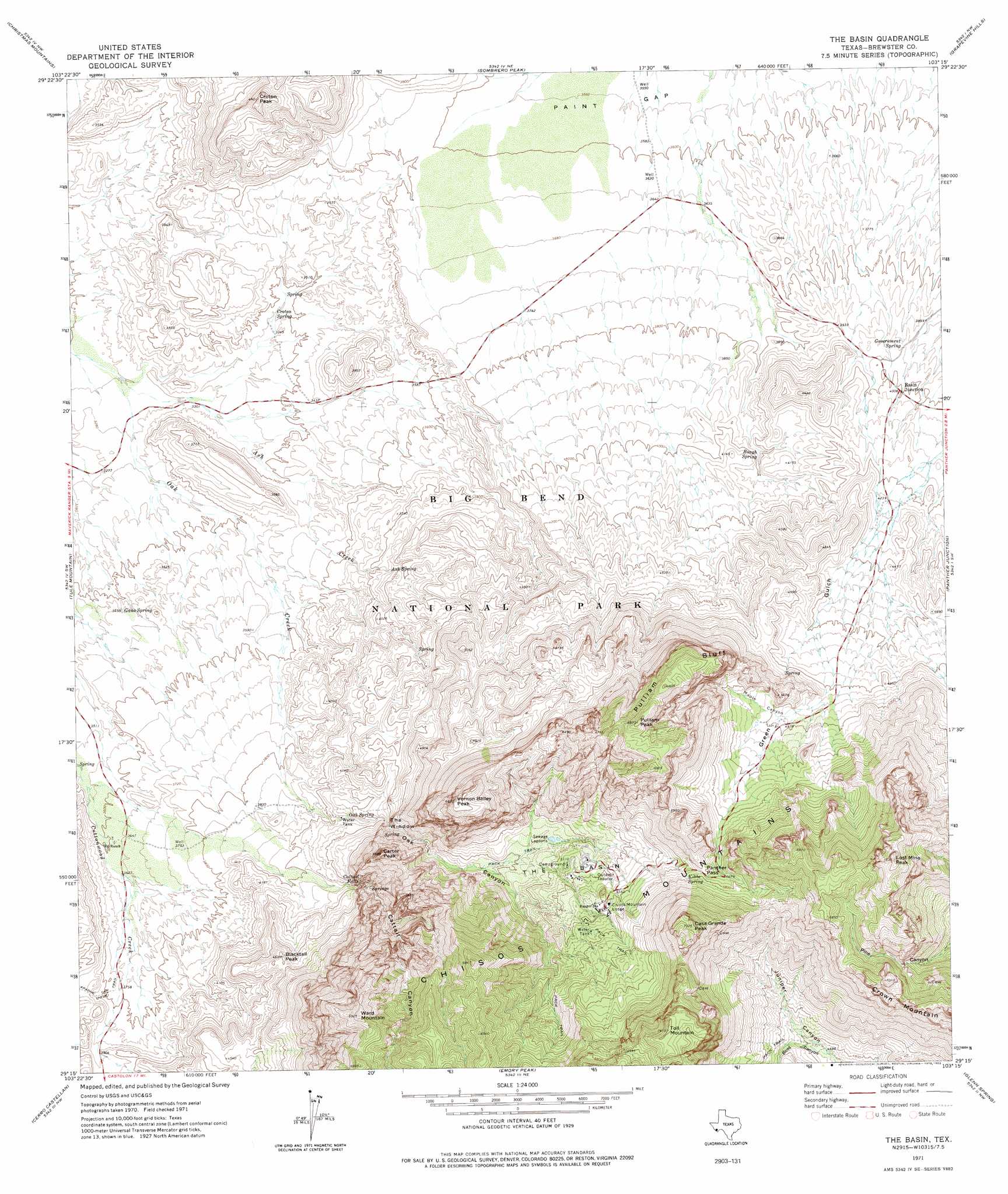
USGS Topo Quad 29103c3 - 1:24,000 scale
| Topo Map Name: | The Basin |
| USGS Topo Quad ID: | 29103c3 |
| Print Size: | ca. 21 1/4" wide x 27" high |
| Southeast Coordinates: | 29.25° N latitude / 103.25° W longitude |
| Map Center Coordinates: | 29.3125° N latitude / 103.3125° W longitude |
| U.S. State: | TX |
| Filename: | o29103c3.jpg |
| Download Map JPG Image: | The Basin topo map 1:24,000 scale |
| Map Type: | Topographic |
| Topo Series: | 7.5´ |
| Map Scale: | 1:24,000 |
| Source of Map Images: | United States Geological Survey (USGS) |
| Alternate Map Versions: |
The Basin TX 1971, updated 1978 Download PDF Buy paper map The Basin TX 1971, updated 1983 Download PDF Buy paper map The Basin TX 1997, updated 1999 Download PDF Buy paper map The Basin TX 2011 Download PDF Buy paper map The Basin TX 2012 Download PDF Buy paper map The Basin TX 2016 Download PDF Buy paper map |
1:24,000 Topo Quads surrounding The Basin
Packsaddle Mountain |
White Hills |
Twin Peaks |
Bone Spring |
Dagger Flat |
Hen Egg Mountain |
Christmas Mountains |
Sombero Peak |
Grapevine Hills |
Mckinney Springs |
Terlingua |
Tule Mountain |
The Basin |
Panther Junction |
Roys Peak |
Castolon |
Cerro Castellan |
Emory Peak |
Glenn Spring |
San Vincente |
Smoky Creek |
Reed Camp |
Mariscal Mountain |
Solis |
> Back to 29103a1 at 1:100,000 scale
> Back to 29102a1 at 1:250,000 scale
> Back to U.S. Topo Maps home
The Basin topo map: Gazetteer
The Basin: Basins
The Basin elevation 1566m 5137′The Basin: Cliffs
Pulliam Bluff elevation 2002m 6568′The Window elevation 1392m 4566′
The Basin: Falls
Cattail Falls elevation 1361m 4465′The Basin: Gaps
Paint Gap elevation 1082m 3549′Panther Pass elevation 1763m 5784′
The Basin: Parks
Big Bend National Park elevation 1616m 5301′The Basin: Populated Places
Basin Junction elevation 1221m 4005′The Basin: Ranges
Chisos Mountains elevation 1696m 5564′The Basin: Springs
Ash Spring elevation 1213m 3979′Cattail Falls Spring elevation 1290m 4232′
Croton Spring elevation 1026m 3366′
Gano Spring elevation 1062m 3484′
Government Spring elevation 1199m 3933′
Kibbe Spring elevation 1757m 5764′
Oak Spring elevation 1278m 4192′
Rough Spring elevation 1222m 4009′
Window Springs elevation 1360m 4461′
The Basin: Streams
Ash Creek elevation 988m 3241′The Basin: Summits
Blacktail Peak elevation 1379m 4524′Carter Peak elevation 1682m 5518′
Casa Grande Peak elevation 2165m 7103′
Croton Peak elevation 1353m 4438′
Crown Mountain elevation 2132m 6994′
Lost Mine Peak elevation 2262m 7421′
Mount Huffman elevation 1918m 6292′
Pulliam Peak elevation 2077m 6814′
Rough Mountain elevation 1355m 4445′
Toll Mountain elevation 2255m 7398′
Vernon Bailey Peak elevation 2018m 6620′
Ward Mountain elevation 2100m 6889′
The Basin: Trails
Basin Loop elevation 1685m 5528′Juniper Canyon Trail elevation 1532m 5026′
Lost Mine Trail elevation 2064m 6771′
The Window Trail elevation 1401m 4596′
The Basin: Valleys
Boot Canyon elevation 1436m 4711′Cattail Canyon elevation 1276m 4186′
Maple Canyon elevation 1472m 4829′
Oak Canyon elevation 1238m 4061′
The Basin digital topo map on disk
Buy this The Basin topo map showing relief, roads, GPS coordinates and other geographical features, as a high-resolution digital map file on DVD: