Longhorn Cavern Topo Map Texas
To zoom in, hover over the map of Longhorn Cavern
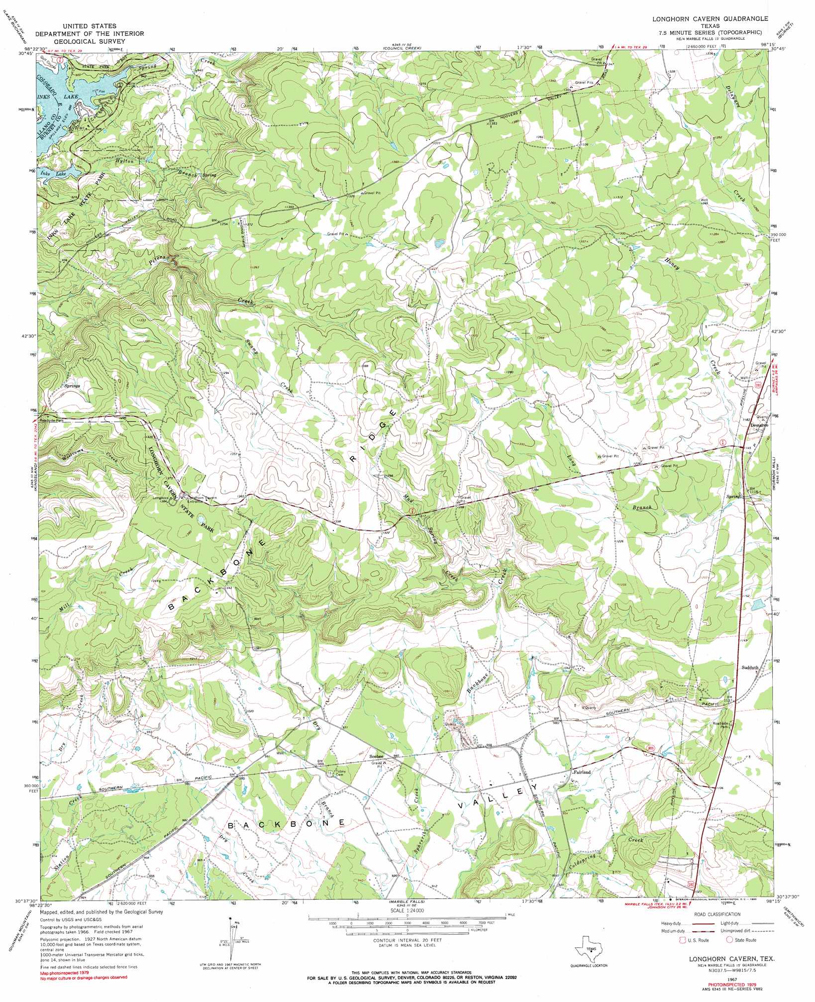
USGS Topo Quad 30098f3 - 1:24,000 scale
| Topo Map Name: | Longhorn Cavern |
| USGS Topo Quad ID: | 30098f3 |
| Print Size: | ca. 21 1/4" wide x 27" high |
| Southeast Coordinates: | 30.625° N latitude / 98.25° W longitude |
| Map Center Coordinates: | 30.6875° N latitude / 98.3125° W longitude |
| U.S. State: | TX |
| Filename: | o30098f3.jpg |
| Download Map JPG Image: | Longhorn Cavern topo map 1:24,000 scale |
| Map Type: | Topographic |
| Topo Series: | 7.5´ |
| Map Scale: | 1:24,000 |
| Source of Map Images: | United States Geological Survey (USGS) |
| Alternate Map Versions: |
Longhorn Cavern TX 1967, updated 1969 Download PDF Buy paper map Longhorn Cavern TX 1967, updated 1990 Download PDF Buy paper map Longhorn Cavern TX 1967, updated 1990 Download PDF Buy paper map Longhorn Cavern TX 2010 Download PDF Buy paper map Longhorn Cavern TX 2012 Download PDF Buy paper map Longhorn Cavern TX 2016 Download PDF Buy paper map |
1:24,000 Topo Quads surrounding Longhorn Cavern
Indian Hills |
Tow |
Naruna |
Lake Victor |
Bachelor Peak |
Lone Grove |
Lake Buchanan |
Council Creek |
Burnet |
Joppa |
Cap Mountain |
Kingsland |
Longhorn Cavern |
Mormon Mill |
Bertram |
Click |
Dunman Mountain |
Marble Falls |
Smithwick |
Travis Peak |
Blowout |
Howell Mountain |
Round Mountain |
Spicewood |
Pace Bend |
> Back to 30098e1 at 1:100,000 scale
> Back to 30098a1 at 1:250,000 scale
> Back to U.S. Topo Maps home
Longhorn Cavern topo map: Gazetteer
Longhorn Cavern: Basins
Backbone Valley elevation 287m 941′Longhorn Cavern: Parks
Inks Lake State Park elevation 281m 921′Longhorn Cavern State Park elevation 416m 1364′
Longhorn Cavern: Populated Places
Fairland elevation 290m 951′Scobee elevation 293m 961′
Sudduth elevation 348m 1141′
Longhorn Cavern: Ridges
Backbone Ridge elevation 441m 1446′Longhorn Cavern: Streams
Hylton Branch elevation 272m 892′Long Branch elevation 335m 1099′
Mud Spring Creek elevation 315m 1033′
Spring Creek elevation 276m 905′
Swamp Creek elevation 352m 1154′
Longhorn Cavern: Trails
Inks Lake State Park Trail elevation 280m 918′Longhorn Cavern State Park Trail elevation 417m 1368′
Longhorn Cavern digital topo map on disk
Buy this Longhorn Cavern topo map showing relief, roads, GPS coordinates and other geographical features, as a high-resolution digital map file on DVD: