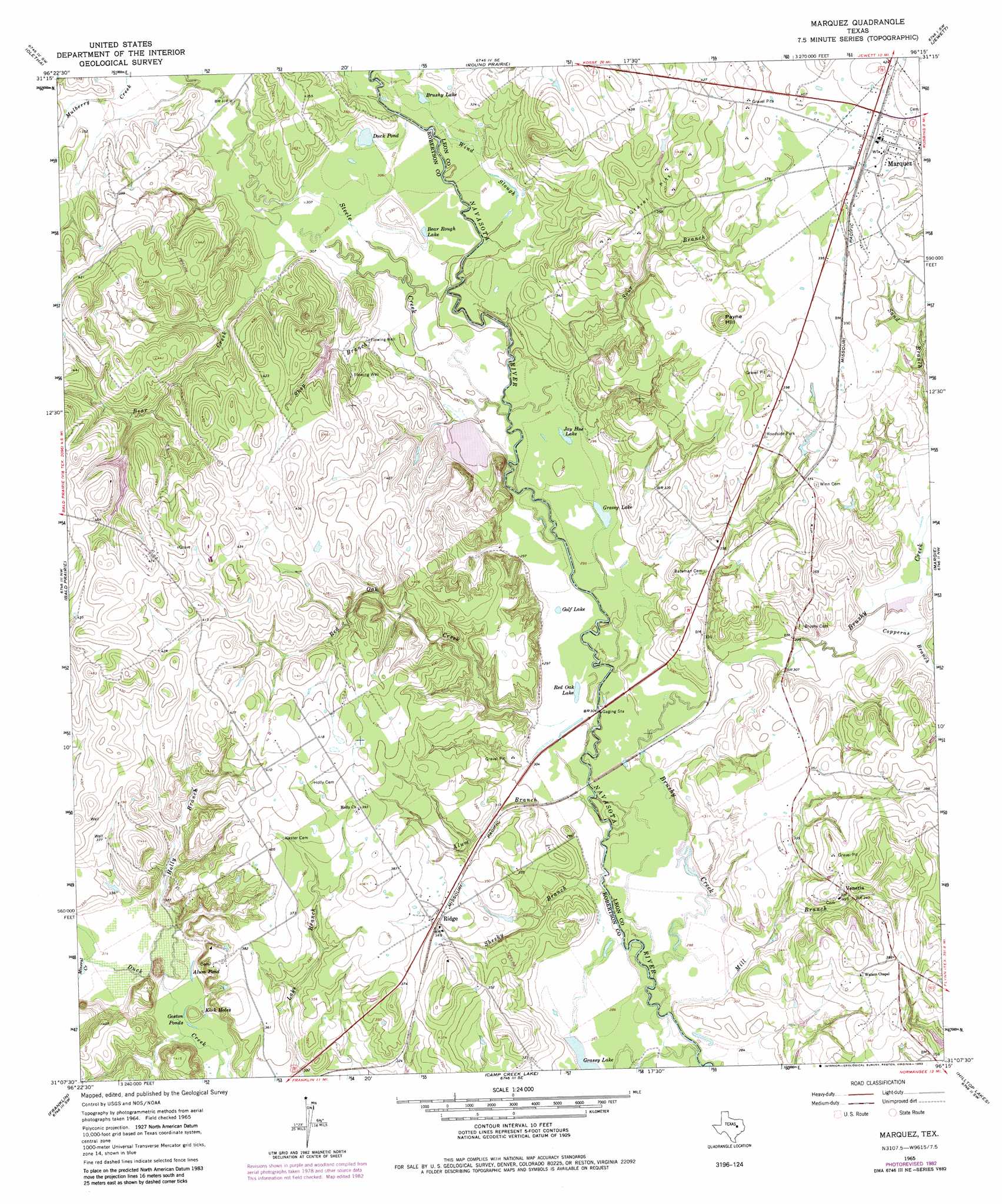
Marquez Topo Map Texas
To zoom in, hover over the map of Marquez
USGS Topo Quad 31096b3 - 1:24,000 scale
| Topo Map Name: | Marquez |
| USGS Topo Quad ID: | 31096b3 |
| Print Size: | ca. 21 1/4" wide x 27" high |
| Southeast Coordinates: | 31.125° N latitude / 96.25° W longitude |
| Map Center Coordinates: | 31.1875° N latitude / 96.3125° W longitude |
| U.S. State: | TX |
| Filename: | o31096b3.jpg |
| Download Map JPG Image: | Marquez topo map 1:24,000 scale |
| Map Type: | Topographic |
| Topo Series: | 7.5´ |
| Map Scale: | 1:24,000 |
| Source of Map Images: | United States Geological Survey (USGS) |
| Alternate Map Versions: |
Marquez TX 1965, updated 1967 Download PDF Buy paper map Marquez TX 1965, updated 1983 Download PDF Buy paper map Marquez TX 2010 Download PDF Buy paper map Marquez TX 2013 Download PDF Buy paper map Marquez TX 2016 Download PDF Buy paper map |
1:24,000 Topo Quads surrounding Marquez
Thornton |
Box Church |
Farrar |
Donie |
Buffalo |
Kosse East |
Oletha |
Round Prairie |
Jewett |
Robbins |
Petteway |
Bald Prairie |
Marquez |
Margie |
Spring Seat |
Owensville |
Franklin |
Camp Creek Lake |
Hilltop Lakes |
Normangee |
Hearne North |
Wheelock |
Edge |
Canary |
North Zulch |
> Back to 31096a1 at 1:100,000 scale
> Back to 31096a1 at 1:250,000 scale
> Back to U.S. Topo Maps home
Marquez topo map: Gazetteer
Marquez: Dams
Antelope Lake Dam elevation 122m 400′Artesian Lake Dam elevation 90m 295′
Wolf Lake Dam elevation 114m 374′
Marquez: Guts
Wind Slough elevation 93m 305′Marquez: Lakes
Alum Pond elevation 94m 308′Bear Rough Lake elevation 93m 305′
Brushy Lake elevation 93m 305′
Duck Pond elevation 93m 305′
Golf Lake elevation 90m 295′
Goston Ponds elevation 94m 308′
Grassy Lake elevation 89m 291′
Grassy Lake elevation 86m 282′
Jay Hue Lake elevation 90m 295′
Kirk Holes elevation 94m 308′
Red Oak Lake elevation 89m 291′
Marquez: Populated Places
Marquez elevation 124m 406′Ridge elevation 109m 357′
Venetia elevation 115m 377′
Marquez: Reservoirs
Antelope Lake elevation 122m 400′Artesian Lake elevation 90m 295′
Wolf Lake elevation 114m 374′
Marquez: Streams
Alum Branch elevation 86m 282′Bear Creek elevation 91m 298′
Brushy Creek elevation 85m 278′
Coles Branch elevation 104m 341′
Copperas Branch elevation 92m 301′
Holly Branch elevation 95m 311′
Lake Branch elevation 101m 331′
Mill Branch elevation 85m 278′
Mineral Creek elevation 97m 318′
Red Oak Creek elevation 91m 298′
Shesky Branch elevation 85m 278′
Shop Branch elevation 90m 295′
Sour Branch elevation 88m 288′
Steele Creek elevation 89m 291′
Marquez: Summits
Payne Hill elevation 137m 449′Marquez digital topo map on disk
Buy this Marquez topo map showing relief, roads, GPS coordinates and other geographical features, as a high-resolution digital map file on DVD: