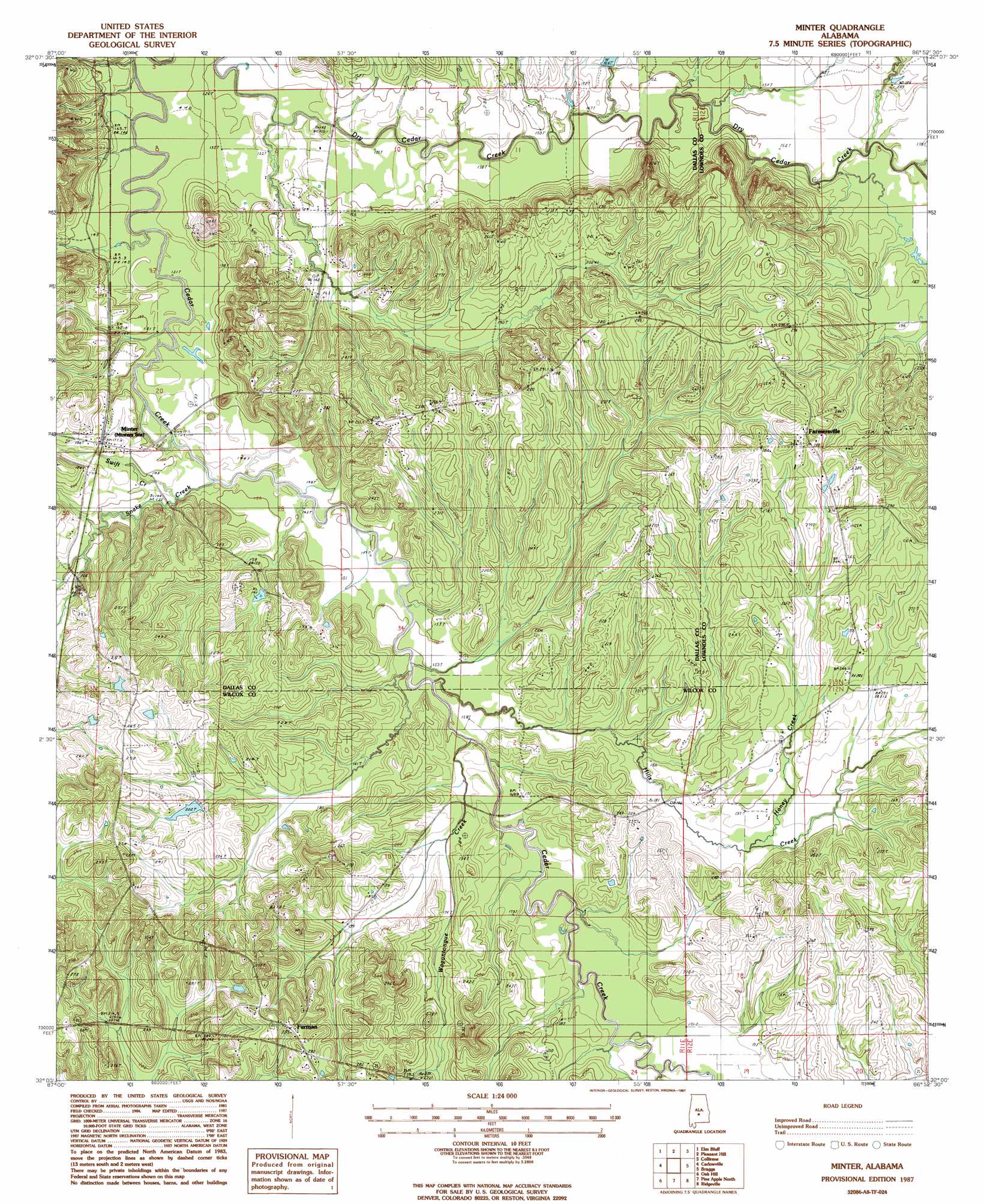
Minter Topo Map Alabama
To zoom in, hover over the map of Minter
USGS Topo Quad 32086a8 - 1:24,000 scale
| Topo Map Name: | Minter |
| USGS Topo Quad ID: | 32086a8 |
| Print Size: | ca. 21 1/4" wide x 27" high |
| Southeast Coordinates: | 32° N latitude / 86.875° W longitude |
| Map Center Coordinates: | 32.0625° N latitude / 86.9375° W longitude |
| U.S. State: | AL |
| Filename: | o32086a8.jpg |
| Download Map JPG Image: | Minter topo map 1:24,000 scale |
| Map Type: | Topographic |
| Topo Series: | 7.5´ |
| Map Scale: | 1:24,000 |
| Source of Map Images: | United States Geological Survey (USGS) |
| Alternate Map Versions: |
Minter AL 1987, updated 1987 Download PDF Buy paper map Minter AL 2011 Download PDF Buy paper map Minter AL 2014 Download PDF Buy paper map |
1:24,000 Topo Quads surrounding Minter
Orrville |
Blackwell Bend |
Sardis |
Benton |
White Hall |
Tasso |
Elm Bluff |
Pleasant Hill |
Collirene |
Gordonsville |
Tilden |
Carlowville |
Minter |
Braggs |
Mount Willing |
Rosebud |
Oak Hill |
Pine Apple North |
Ridgeville |
Fort Dale |
Nadawah |
Mcwilliams |
Pine Apple South |
Forest Home |
Greenville West |
> Back to 32086a1 at 1:100,000 scale
> Back to 32086a1 at 1:250,000 scale
> Back to U.S. Topo Maps home
Minter topo map: Gazetteer
Minter: Dams
Thomas Norris Dam elevation 58m 190′Minter: Populated Places
Dawsons elevation 43m 141′Farmersville elevation 86m 282′
Furman elevation 89m 291′
Minter elevation 54m 177′
Minter: Post Offices
Minter Post Office elevation 52m 170′Minter: Reservoirs
Thomas Norris Pond elevation 58m 190′Minter: Streams
Hills Creek elevation 44m 144′Honey Creek elevation 55m 180′
Snake Creek elevation 40m 131′
Swift Creek elevation 43m 141′
Tucker Branch elevation 50m 164′
Wagontongue Creek elevation 47m 154′
Minter digital topo map on disk
Buy this Minter topo map showing relief, roads, GPS coordinates and other geographical features, as a high-resolution digital map file on DVD:
Gulf Coast (LA, MS, AL, FL) & Southwestern Georgia
Buy digital topo maps: Gulf Coast (LA, MS, AL, FL) & Southwestern Georgia
 & Southwestern Georgia map DVD")