Cullen Topo Map Louisiana
To zoom in, hover over the map of Cullen
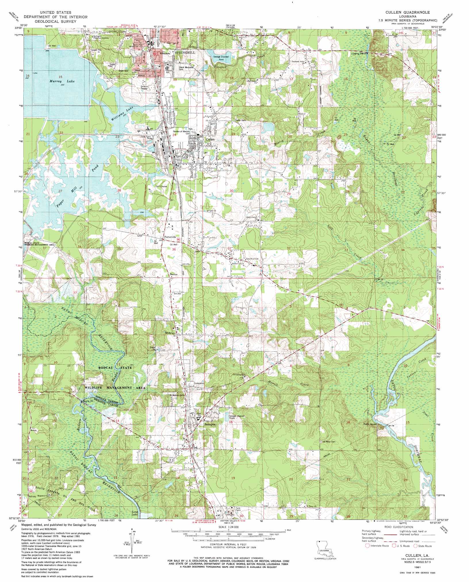
USGS Topo Quad 32093h4 - 1:24,000 scale
| Topo Map Name: | Cullen |
| USGS Topo Quad ID: | 32093h4 |
| Print Size: | ca. 21 1/4" wide x 27" high |
| Southeast Coordinates: | 32.875° N latitude / 93.375° W longitude |
| Map Center Coordinates: | 32.9375° N latitude / 93.4375° W longitude |
| U.S. State: | LA |
| Filename: | o32093h4.jpg |
| Download Map JPG Image: | Cullen topo map 1:24,000 scale |
| Map Type: | Topographic |
| Topo Series: | 7.5´ |
| Map Scale: | 1:24,000 |
| Source of Map Images: | United States Geological Survey (USGS) |
| Alternate Map Versions: |
Cullen LA 1981, updated 1981 Download PDF Buy paper map Cullen LA 1981, updated 1981 Download PDF Buy paper map Cullen LA 2012 Download PDF Buy paper map Cullen LA 2015 Download PDF Buy paper map |
1:24,000 Topo Quads surrounding Cullen
Canfield |
Bradley Ne |
Bussey |
Macedonia |
Calhoun |
Bradley |
Bradley Se |
Taylor |
Walkerville |
Emerson |
Plain Dealing |
Carterville |
Cullen |
Shongaloo |
Haynesville West |
Hughes |
Ivan |
Cotton Valley |
Leton |
Blackburn |
Benton |
Bodcau Lake |
Hortman |
Minden North |
Langston |
> Back to 32093e1 at 1:100,000 scale
> Back to 32092a1 at 1:250,000 scale
> Back to U.S. Topo Maps home
Cullen topo map: Gazetteer
Cullen: Airports
Springhill Airport elevation 66m 216′Cullen: Dams
Empounding Basin Number 1 Dam elevation 70m 229′Williams Lake Dam elevation 71m 232′
Cullen: Flats
Hickory Flat elevation 75m 246′Oak Flat elevation 73m 239′
The Flats elevation 73m 239′
Cullen: Lakes
Williams Lake elevation 71m 232′Cullen: Oilfields
Sarepta Oil and Gas Field elevation 56m 183′Stroud Bridge Oil Field elevation 70m 229′
Cullen: Parks
Carldon Martin Park elevation 76m 249′Ludwig Recreation Park elevation 75m 246′
Melvin Boucher Park elevation 77m 252′
West Side Recreation Area elevation 73m 239′
Cullen: Populated Places
Baccus elevation 82m 269′Bunker elevation 77m 252′
Clifford elevation 75m 246′
Cullen elevation 75m 246′
East Side Subdivision elevation 73m 239′
Meadow Creek Ranch elevation 67m 219′
Meadow Creek Subdivision elevation 69m 226′
Midway elevation 80m 262′
Pine Hill Subdivision elevation 73m 239′
Porterville elevation 81m 265′
Robin Hood Subdivision elevation 82m 269′
Sarepta elevation 78m 255′
White Way Subdivision elevation 70m 229′
Cullen: Post Offices
Cullen Post Office elevation 77m 252′Cullen: Reservoirs
Murray Lake elevation 74m 242′Paper Mill Pond elevation 68m 223′
Cullen: Streams
Braley Creek elevation 56m 183′Crooked Creek elevation 55m 180′
Cypress Creek elevation 53m 173′
Howell Creek elevation 55m 180′
Indian Creek elevation 53m 173′
Near Creek elevation 55m 180′
Cullen digital topo map on disk
Buy this Cullen topo map showing relief, roads, GPS coordinates and other geographical features, as a high-resolution digital map file on DVD: