Chatfield Topo Map Texas
To zoom in, hover over the map of Chatfield
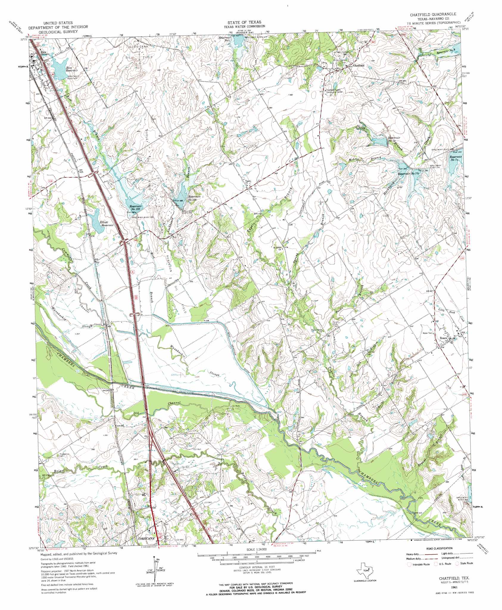
USGS Topo Quad 32096b4 - 1:24,000 scale
| Topo Map Name: | Chatfield |
| USGS Topo Quad ID: | 32096b4 |
| Print Size: | ca. 21 1/4" wide x 27" high |
| Southeast Coordinates: | 32.125° N latitude / 96.375° W longitude |
| Map Center Coordinates: | 32.1875° N latitude / 96.4375° W longitude |
| U.S. State: | TX |
| Filename: | o32096b4.jpg |
| Download Map JPG Image: | Chatfield topo map 1:24,000 scale |
| Map Type: | Topographic |
| Topo Series: | 7.5´ |
| Map Scale: | 1:24,000 |
| Source of Map Images: | United States Geological Survey (USGS) |
| Alternate Map Versions: |
Chatfield TX 1961, updated 1966 Download PDF Buy paper map Chatfield TX 2010 Download PDF Buy paper map Chatfield TX 2012 Download PDF Buy paper map Chatfield TX 2016 Download PDF Buy paper map |
1:24,000 Topo Quads surrounding Chatfield
Palmer |
Bristol |
Rosser |
Grays Prairie |
Kemp |
Ennis West |
Ennis East |
Rosser Sw |
Styx |
Tool |
Cryer Creek |
Emhouse |
Chatfield |
Bazette |
Kerens |
Blooming Grove |
Corbet |
Corsicana |
Powell |
Goodlow Park |
Dawson |
Purdon |
Richland |
Streetman |
Winkler |
> Back to 32096a1 at 1:100,000 scale
> Back to 32096a1 at 1:250,000 scale
> Back to U.S. Topo Maps home
Chatfield topo map: Gazetteer
Chatfield: Dams
Allison South Lake Dam elevation 135m 442′Johnston Lake Dam elevation 118m 387′
Rice Lake Dam elevation 128m 419′
Soil Conservation Service Site 128 Dam elevation 117m 383′
Soil Conservation Service Site 129 Dam elevation 122m 400′
Soil Conservation Service Site 131 Dam elevation 117m 383′
Soil Conservation Service Site 7a Dam elevation 121m 396′
Soil Conservation Service Site 7b Dam elevation 111m 364′
Soil Conservation Service Site 7c Dam elevation 115m 377′
Wheelock Lake Dam elevation 106m 347′
Chatfield: Oilfields
Dudley Oil Field elevation 124m 406′Robinson Oil Field elevation 108m 354′
Chatfield: Populated Places
Chatfield elevation 131m 429′Rice elevation 140m 459′
Roane elevation 131m 429′
Tupelo elevation 133m 436′
Chatfield: Reservoirs
Allison South Lake elevation 135m 442′Elliott Reservoir elevation 117m 383′
Johnston Lake elevation 118m 387′
Reservoir Number Four elevation 125m 410′
Reservoir Number One Hundred Twentyeight elevation 117m 383′
Reservoir Number One Hundred Twentynine elevation 120m 393′
Reservoir Number Seven A elevation 120m 393′
Reservoir Number Seven B elevation 114m 374′
Reservoir Number Seven C elevation 115m 377′
Rice Lake elevation 128m 419′
Rice Reservoir elevation 128m 419′
Soil Conservation Service Site 128 Reservoir elevation 117m 383′
Soil Conservation Service Site 129 Reservoir elevation 122m 400′
Soil Conservation Service Site 131 Reservoir elevation 117m 383′
Soil Conservation Service Site 7a Reservoir elevation 121m 396′
Soil Conservation Service Site 7b Reservoir elevation 111m 364′
Soil Conservation Service Site 7c Reservoir elevation 115m 377′
Wheelock Lake elevation 106m 347′
Chatfield: Streams
Bryant Branch elevation 93m 305′Burke Branch elevation 102m 334′
Cummins Creek elevation 101m 331′
Lockheart Branch elevation 107m 351′
Middle Branch Hackberry Creek elevation 112m 367′
North Branch Hackberry Creek elevation 104m 341′
Old Channel elevation 104m 341′
Pecan Branch elevation 111m 364′
Post Oak Branch elevation 104m 341′
Rice Branch elevation 104m 341′
Spring Branch elevation 117m 383′
Tupelo Branch elevation 92m 301′
Chatfield digital topo map on disk
Buy this Chatfield topo map showing relief, roads, GPS coordinates and other geographical features, as a high-resolution digital map file on DVD: