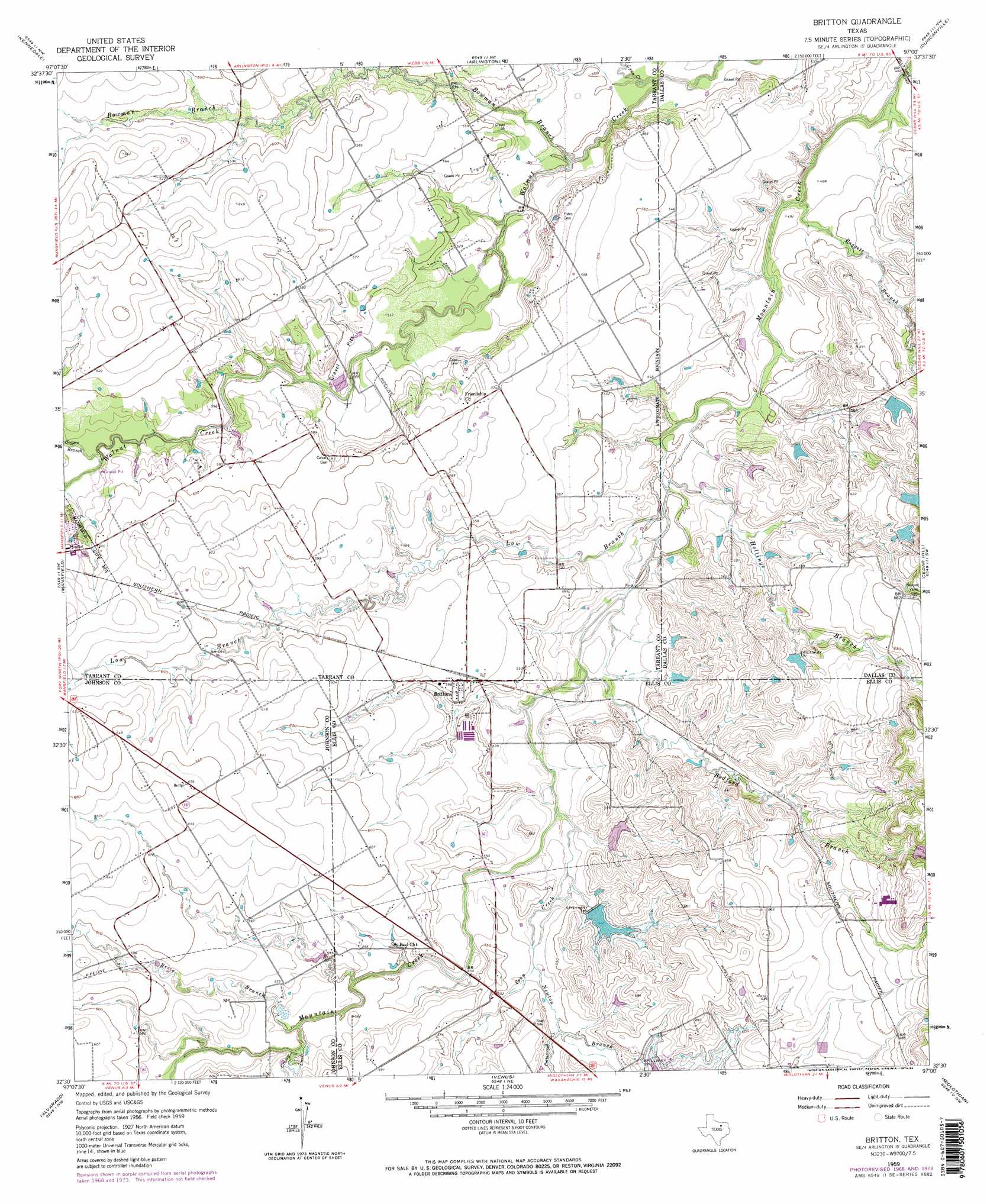
Britton Topo Map Texas
To zoom in, hover over the map of Britton
USGS Topo Quad 32097e1 - 1:24,000 scale
| Topo Map Name: | Britton |
| USGS Topo Quad ID: | 32097e1 |
| Print Size: | ca. 21 1/4" wide x 27" high |
| Southeast Coordinates: | 32.5° N latitude / 97° W longitude |
| Map Center Coordinates: | 32.5625° N latitude / 97.0625° W longitude |
| U.S. State: | TX |
| Filename: | o32097e1.jpg |
| Download Map JPG Image: | Britton topo map 1:24,000 scale |
| Map Type: | Topographic |
| Topo Series: | 7.5´ |
| Map Scale: | 1:24,000 |
| Source of Map Images: | United States Geological Survey (USGS) |
| Alternate Map Versions: |
Britton TX 1959, updated 1960 Download PDF Buy paper map Britton TX 1959, updated 1966 Download PDF Buy paper map Britton TX 1959, updated 1969 Download PDF Buy paper map Britton TX 1959, updated 1974 Download PDF Buy paper map Britton TX 1959, updated 1984 Download PDF Buy paper map Britton TX 1959, updated 1984 Download PDF Buy paper map Britton TX 1995, updated 2002 Download PDF Buy paper map Britton TX 2010 Download PDF Buy paper map Britton TX 2013 Download PDF Buy paper map Britton TX 2016 Download PDF Buy paper map |
1:24,000 Topo Quads surrounding Britton
Haltom City |
Hurst |
Euless |
Irving |
Dallas |
Fort Worth |
Kennedale |
Arlington |
Duncanville |
Oak Cliff |
Burleson |
Mansfield |
Britton |
Cedar Hill |
Lancaster |
Keene |
Alvarado |
Venus |
Midlothian |
Waxahachie |
Cleburne East |
Grandview |
Maypearl |
Boz |
Forreston |
> Back to 32097e1 at 1:100,000 scale
> Back to 32096a1 at 1:250,000 scale
> Back to U.S. Topo Maps home
Britton topo map: Gazetteer
Britton: Airports
Jack Miller Stolport elevation 183m 600′Britton: Dams
Gifford-Hill Dam elevation 207m 679′Magic Valley Ranch Lake Dam elevation 181m 593′
Soil Conservation Service Site 11 Dam elevation 166m 544′
Britton: Parks
Britton Park elevation 160m 524′Estes Park elevation 163m 534′
Loyd Park elevation 168m 551′
Mansfield City Park elevation 177m 580′
McKnight Park elevation 174m 570′
Pleasant Valley Park elevation 170m 557′
Webb Park elevation 160m 524′
Britton: Populated Places
Britton elevation 171m 561′Britton: Reservoirs
Gifford-Hill Lake elevation 207m 679′Magic Valley Ranch Lake elevation 181m 593′
Soil Conservation Service Site 11 Reservoir elevation 166m 544′
Britton: Streams
Baggett Branch elevation 155m 508′Bedford Branch elevation 155m 508′
Bowman Branch elevation 155m 508′
Cottonwood Creek elevation 168m 551′
Grassy Creek elevation 167m 547′
Hogpen Branch elevation 170m 557′
Hollings Branch elevation 155m 508′
Low Branch elevation 155m 508′
Lynn Creek elevation 155m 508′
Newton Branch elevation 164m 538′
Reece Branch elevation 164m 538′
Soap Creek elevation 158m 518′
Britton: Trails
Loyd Park Trail elevation 164m 538′Britton digital topo map on disk
Buy this Britton topo map showing relief, roads, GPS coordinates and other geographical features, as a high-resolution digital map file on DVD: